
Page 112 - Social Studies 7
P. 112
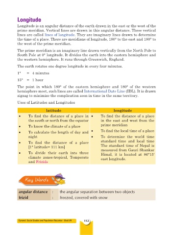
Longitude

           Longitude is an angular distance of the earth drawn in the east or the west of the
           prime meridian. Vertical lines are drawn in this angular distance. These vertical
           lines are called lines of longitude. They are imaginary lines drawn to determine
           the time of a place. There are meridians of longitude, 180° to the east and 180° to
           the west of the prime meridian.
           The prime meridian is an imaginary line drawn vertically from the North Pole to
           South Pole at 0° longitude. It divides the earth into the eastern hemisphere and
           the western hemisphere. It runs through Greenwich, England.

           The earth rotates one degree longitude in every four minutes.
           1°    =   4 minutes

           15°   =   1 hour

           The  point in  which  180° of the eastern  hemisphere  and 180° of the western
           hemisphere meet, such lines are called International Date Line (IDL). It is drawn
           zigzag to minimize the complication seen in time in the same territory.
           Uses of Latitudes and Longitudes

                            latitude                                longitude
            •     To  find  the  distance  of  a  place  in  •   To find the distance of a place
                  the south or north from the equator        in the east and west from the
            •     To know the climate of a place             prime meridian
            •     To calculate the length of day and   •     To find the local time of a place
                  night                                •     To  determine  the  world  time
            •     To  find  the  distance  of  a  place      standard time  and local  time
                  [1° latitude= 111 km]                      The standard time of Nepal is
                                                             measured from Gauri Shankar
            •     To divide their earth into three           Himal, it is located at 86°15'
                  climate zones-tropical,  Temperate         east longitude.
                  and Frizids


                Key Words


            angular distance    :    the angular separation between two objects
            frizid              :    freezed, covered with snow


            Dynamic Social Studies and Population Education - Book VII  112