
Page 271 - (DK Eyewitness) Travel Guide - Morocco
P. 271
OU ARZAZA TE & THE SOUTHERN O ASES 269
most important tribe in
southern Morocco. This semi-
nomadic people never bowed
to the power of the sultans, and
they were the last to resist the
French at the Battle of Bou Gafer
in 1933. They live in ksour, but
take to tents for part of the year,
when they drive livestock to
seasonal pastures.
Jbel Sarhro is a region of
sheer rockfaces, plateaux and
blackish rocky escarpments. The
rugged territory is crossed from
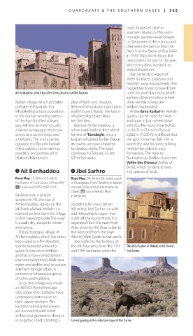
Aït Benhaddou, which has often been chosen as a film location north to south by tracks, which
are best driven in a four-wheel-
Berber village, which probably play of light and shadow. drive vehicle (routes are
predates the kasbah. It is Behind the kasbahs stand plain seldom signposted).
inhabited by a busy population. earth houses. Today, the ksar is At the Baha Kasbah in Nekob
In the narrow winding streets inhabited by fewer than guides can be hired for hikes
of the ksar (fortified village), ten families. and tours in four-wheel-drive
you will find an Internet café, Beyond Aït Benhaddou, a vehicles. The route from Nekob
a former synagogue that now minor road leads to the ruined to the Tizi n’Tazazert Pass, at
serves as a carpet shop, and fortress of Tamdaght, once a 2,200 m (7,220 ft), is difficult, but
a herbalist. The crafts centre kasbah inhabited by the Glaoui. the spot known as Bab n’Ali is
opposite the Taourirt kasbah Its towers are now inhabited worth the visit for some striking
offers carpets, stone carving, by nesting storks. The road needle-like volcanic rock
jewellery and pottery, all at continues to Telouet, 32 km formations. The track to
relatively high prices. (20 miles) away. Boumalne du Dadès crosses the
Vallée des Oiseaux (Valley of
Birds), which is home to over
3 Aït Benhaddou 4 Jbel Sarhro 150 species of birds.
Road Map C4. 30 km (19 miles) Road Map: D4. 98 km (61 miles) south
northwest of Ouarzazate, off road N9. of Ouarzazate. From Tansikht to Nekob
n Ouarzazate; (0524) 88 24 85. on road R108, or from Boumalne du
Dadès. ( Sun in Nekob; Mon
Backing onto a pinkish in Ikniounn.
sandstone hill, the ksar of
Aït Benhaddou stands on the Stretching for over 100 km
left bank of Wadi Mellah. It is (60 miles), Jbel Sarhro is a wild
reached on foot from the village and inhospitable region that
on the opposite bank. The wadi is still off the tourist track. It is
is usually dry, except in winter separated from the main Anti-
and spring. Atlas chain by the Draa valley to
The picturesque village of the west and from the High
Aït Benhaddou, which has often Atlas by Wadi Dadès to the north.
been used as a film location, Jbel Sarhro is the territory of
can be explored without a the Aït Atta, who, from the 17th The Baha Kasbah in Nekob, at the foot of
guide. It was once fortified and 19th centuries, were the Jbel Sarhro
and has a now-ruined igherm
(communal granary). Built near
water and arable land, in a place
safe from foreign attack, it
contains an impressive group
of ochre pisé kasbahs.
Since the village was made
a UNESCO World Heritage
Site, some of its kasbahs have
undergone restoration to
their upper sections. The
kasbahs’ crenellated towers
are decorated with blind
arches and geometric designs
in negative relief, creating a Camels grazing in the rocky landscape of Jbel Sarhro
268-269_EW_Morocco.indd 269 09/08/16 11:20 am