
Page 266 - Ultimate Visual Dictionary (DK)
P. 266
GEOLOGY, GEOGRAPHY, AND METEOROLOGY
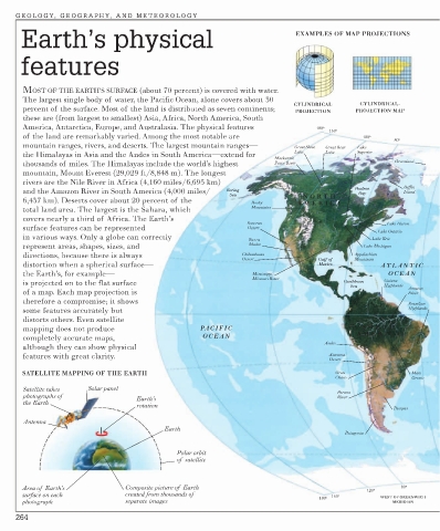
Earth’s physical EXAMPLES OF MAP PROJECTIONS
features
MOST OF THE EARTH’S SURFACE (about 70 percent) is covered with water.
The largest single body of water, the Pacific Ocean, alone covers about 30
CYLINDRICAL CYLINDRICAL-
percent of the surface. Most of the land is distributed as seven continents; PROJECTION PROJECTION MAP
these are (from largest to smallest) Asia, Africa, North America, South
America, Antarctica, Europe, and Australasia. The physical features 180o
160o
of the land are remarkably varied. Among the most notable are 120o
80o
mountain ranges, rivers, and deserts. The largest mountain ranges— Great Slave Great Bear Lake
the Himalayas in Asia and the Andes in South America—extend for Lake Lake Superior
Mackenzie-
thousands of miles. The Himalayas include the world’s highest Peace River Greenland
mountain, Mount Everest (29,029 ft/8,848 m). The longest
rivers are the Nile River in Africa (4,160 miles/6,695 km)
and the Amazon River in South America (4,000 miles/ Bering Hudson Baffin
Island
Bay
Sea NOR TH
6,437 km). Deserts cover about 20 percent of the Rocky AMERICA
total land area. The largest is the Sahara, which Mountains
covers nearly a third of Africa. The Earth’s
Sonoran Lake Huron
surface features can be represented Desert
Lake Ontario
in various ways. Only a globe can correctly Lake Erie
Sierra
represent areas, shapes, sizes, and Madre Lake Michigan
directions, because there is always Chihuahuan Appalachian
Desert Gulf of Mountains
distortion when a spherical surface— Mexico ATLANTIC
the Earth’s, for example— Mississippi- OCEAN
Missouri River
is projected on to the flat surface Caribbean Guiana
Sea Highlands Amazon
of a map. Each map projection is River
therefore a compromise; it shows Brazilian
some features accurately but Highlands
distorts others. Even satellite
mapping does not produce PACIFIC SOUTH
AMERICA
completely accurate maps, OCEAN
Andes
although they can show physical
features with great clarity. Atacama
Desert
SATELLITE MAPPING OF THE EARTH Gran Mato
Chaco Grosso
Satellite takes Solar panel Parana
photographs of Earth’s River
the Earth
rotation
Pampas
Antenna
Earth
Patagonia
Polar orbit
of satellite
Area of Earth’s Composite picture of Earth 120o 80o
surface on each created from thousands of 160o
180o WEST OF GREENWICH
photograph separate images MERIDIAN
264