
Page 446 - (DK Eyewitness) Travel Guide - USA
P. 446
444 THE GREA T PLAINS
Nebraska 230-mile- (370-km-) long
Pine Ridge escarpment.
Nebraska’s vast, grassy expanses of open range, and ruts Hikers and mountain bikers
from old overland wagon routes, epitomize the geography seeking more challenging
and history of the Great Plains. The modern I-80 freeway routes can follow the 25-mile
stretches westward in the shadow of the wide Platte River (40-km) Pine Ridge Trail, a steep,
meandering route leading
Valley, the historic Oregon, Mormon, and Pony Express Trails, through patches of meadows
and the original Lincoln Highway (now US 30). Farther north, and thick stands of ponderosa
the sparsely settled central Nebraska Sandhills contain some pine. The trail is part of the
of the nation’s largest expanses of unbroken, mixed-grass Pine Ridge National Recreation
prairie, while the Panhandle in the northwest is studded Area, a craggy portion of the
with rocky outcrops and jagged canyons. The state’s two vast Nebraska National Forest,
which runs along the brow
largest cities, Omaha and Lincoln, are in the southeast. of the escarp ment, south of
US 20, between Chadron
e Chadron being relocated at Pine Ridge and Crawford.
(see p441). In 1877, the great
* 5,600. ~ n 706 W 3rd St, (800) P Fort Robinson State Park
603-2937. ∑ chadron.com Oglala Sioux chief, Crazy Horse
(see p442), and 900 of his tribe US 20, 3 miles (5 km) W of Crawford.
Chadron is the ideal base to surrendered and set up camp Tel (308) 665-2900. Open daily. 7
tour the Pine Ridge and outside of the fort. In a series ∑ outdoornebraska.ne.gov
Sandhills regions as well as of tragic events, Crazy Horse
explore aspects of the state’s was killed while federal troops
fascinating past. About 3 miles attempted to imprison him.
(5 km) east of town is the A restored blockhouse
Museum of the Fur Trade. Built commemorates the site
on the grounds of an 1833–49 where he fell.
American Fur Company post, The excellent Fort Robinson
the museum traces the history Museum details the fort’s other
of the complex North American lives as an experimental cattle
fur trade and its effect on ranch and a training ground for
Native American communities. the army’s World War II canine
One of its main features is a corps. The fort’s restored
reconstructed trading post quarters provide accom-
built into the sides of a low hill. modations for visitors, while
The area’s key historical horseback trails lead through Martin Bay in Lake McConaughy State
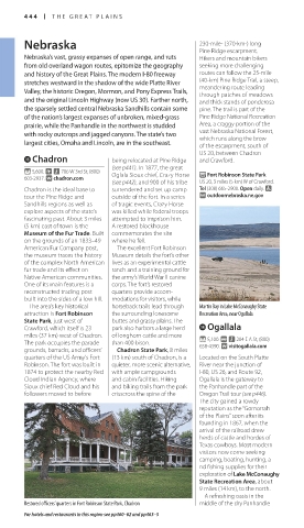
attraction is Fort Robinson the surrounding lonesome Recreation Area, near Ogallala
State Park, just west of buttes and grassy plains. The
Crawford, which itself is 23 park also harbors a large herd r Ogallala
miles (37 km) west of Chadron. of longhorn cattle and more * 5,100. @ n 204 E A St, (800)
The park occupies the parade than 400 bison. 658-4390. ∑ visitogallala.com
grounds, barracks, and officers’ Chadron State Park, 8 miles
quarters of the US Army’s Fort (13 km) south of Chadron, is a Located on the South Platte
Robinson. The fort was built in quieter, more scenic alternative, River near the junction of
1874 to protect the nearby Red with ample campgrounds I-80, US 26, and Route 92,
Cloud Indian Agency, where and cabin facilities. Hiking Ogallala is the gateway to
Sioux chief Red Cloud and his and biking trails from the park the Panhandle part of the
followers moved to before crisscross the spine of the Oregon Trail tour (see p446).
The city gained a rowdy
reputation as the “Gomorrah
of the Plains” soon after its
founding in 1867, when the
arrival of the railroad drew
herds of cattle and hordes of
Texas cowboys. Most modern
visitors now come seeking
camping, boating, hunting, a
nd fishing supplies for their
exploration of Lake McConaughy
State Recreation Area, about
9 miles (14 km), to the north.
A refreshing oasis in the
Restored officers’ quarters in Fort Robinson State Park, Chadron middle of the dry Panhandle
For hotels and restaurants in this region see pp460–62 and pp463–5
444-445_EW_USA.indd 444 11/2/16 2:46 PM
Eyewitness Travel LAYERS PRINTED:
Catalogue template “UK” LAYER
(Source v2.6)
Date 12th July 2013
Size 125mm x 217mm