Page 631 - (DK Eyewitness) Travel Guide - USA
P. 631

OREGON      629


                                               Tips for Walkers
                                               Tour length: 214 miles (344 km),
                                               including all turnoffs.
                                               Starting point: Oregon SR 350,
                                               8 miles (13 km) east of Joseph.
                                               When to go: Summer months
    Salmon River                               only. Some roads are not suitable
                                               for every type of vehicle. For
                                               information, call the area’s visitor
                                               center at (541) 426-5546.
                                               Stopping off points: Picnic areas
                                               are widely available. Imnaha
                                  3 Imnaha River   offers restaurants and lodging.
                              A road from the town of
 J
                           Imnaha follows this frothy river
                           through a pine-scented valley,
                             isolated ranches, and a fish
                            weir where Chinook salmon,   4 Hat Point Road
                             having migrated from the
                             Pacific Ocean, can be seen   A steep, dizzying, 23-mile
                  Pittsburg     swimming upstream.  (37-km) gravel road takes
                   Landing                      visitors up to Hat Point,
                                                located at an elevation
                                                of 7,000 ft (2,100 m).
  Imnaha                         Key
                   Snake River      Tour route
                                    Other road  0 kilometers  10
                                                0 miles        10

             J
  Imnaha River Road  Seven Devils

                Mountains
 Big Sheep Creek

            Hells Canyon
            Dam


     J
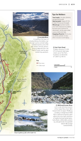
                                                  5 Wild and Scenic River
                                                 A 31.5-mile (50.5-km) stretch
                                                 of the Snake River, from Hells
      Big Bar
                                               Canyon Dam to Upper Pittsburg
                                                 Landing, is designated a Wild
                                                River. Experienced guides pilot
 North Pine Creek                              tures, bears, rattlesnakes, poison
                                                rafters over the many stretches
                                                of rapids, but searing tempera-
 Copperfield  Oxbow                             ivy, and generally inhospitable
                                                      terrain discourage
   Dam
                                                        overland treks.
 Baker City
             A boat negotiating rapids on the Snake River

                                                   For keys to symbols see back flap


   628-629_EW_USA.indd   629                                  11/2/16   5:32 PM
   626   627   628   629   630   631   632   633   634   635   636