
Page 8 - (DK Eyewitness) Travel Guide - USA
P. 8
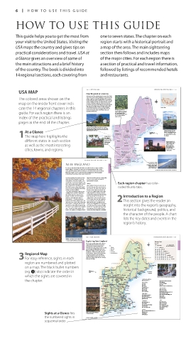
6 HOW T O USE THIS GUIDE
HOW TO USE THIS GUIDE
This guide helps you to get the most from one to seven states. The chapter on each
your visit to the United States. Visiting the region starts with a historical portrait and
USA maps the country and gives tips on a map of the area. The main sightseeing
practical considerations and travel. USA at section then follows and includes maps
a Glance gives an overview of some of of the major cities. For each region there is
the main attractions and a brief history a section of practical and travel information,
of the country. The book is divided into followed by listings of recommended hotels
14 regional sections, each covering from and restaurants.
USA MAP 130 NE W ENGLAND INTRODUCING NE W ENGLAND 131
New England at a Glance
Tucked away in the northeasternmost corner of the United
The colored areas shown on the culture as well as in natural beauty. Many of the country’s Fort Kent
States, the six states of New England are rich in history and
earliest settlements were established here, as were the first
map on the inside front cover indi- centers of higher education. The region therefore abounds Presque Isle
in historic buildings, as well as in superb museums and
prestigious universities. New England’s topography includes
large tracts of farmland, dense woodlands, pristine lakes,
cate the 14 regional chapters in this and sweeping coastlines, which are rocky and jagged Vermont is an enclave of Locator Map
in some areas and serene and sandy in others. It is also
home to the rugged peaks of the White, Green, and
guide. For each region there is an Appalachian Mountains. unspoiled wilderness. Vermont
is at its scenic best in fall, when
the Green Mountain State
changes its verdant green cloak
index of the practical and listings for a rich palette of yellow, MAINE
orange, and red.
(See pp178–81) Calais
pages at the end of the chapter. Bangor
Skowhegan
Ellsworth
Canterbury Shaker Village (see p176), located in New
Hampshire, was founded in 1792. This is one of the many
picturesque historic villages that are scattered around the Augusta Maine has around 3,500 miles
At a Glance rolling farmlands of the state. Burlington Bretton Woods 0 kilometers 50 (6,000 km) of inlets, bays, and
harbors. Dotted along the coast
are a string of lighthouses that
1The map here highlights the Connecticut VERMONT HAMPSHIRE 0 miles 50 have guided mariners to safety
(See pp170–73)
NEW
for centuries.
is quintessential
New England. (See pp174–77) Portland
different states in each section Steepled churches Rutland Boston (see pp138–55)
around immaculate
village greens are
is New England’s largest
typical features
as well as the most interesting of its serene Concord Portsmouth and most vibrant city,
and the capital of
landscape.
Manchester
Massachusetts. Here,
Bennington historic buildings and
cities, towns, and regions. Cambridge gleaming modern
structures can be found
cheek by jowl.
MASSACHUSETTS
(See pp138–59) Boston
Springfield Plymouth
Providence
RHODE
ISLAND
INTRODUCING NE W ENGLAND 133 Hartford (See pp160–63)
CONNECTICUT Newport Cape Cod (see p158–9) in
NEW ENGLAND (See pp164–67) known for its miles of wide,
Massachusetts is best
Block Island (see p163) in Rhode Island is one of the
New Haven
many tranquil havens situated along the pristine
shoreline of this tiny state. Great Salt Pond has three sandy beaches, whale-
marinas and is an excellent spot for kayaking and fishing.
watching junkets, and
For many people, New England is white-steepled churches, craggy coastlines, Stamford quaint Colonial villages.
historic villages, and timeless landscapes of tranquil farmlands and country For hotels and restaurants in this region see pp184–6 and pp187–9
Portland Head Lighthouse in Cape Elizabeth, Fort Williams Park, Maine
roads, with the sophisticated city of Boston as its cultural and commercial hub.
Many also regard it as the cradle of American civilization, for New England’s
early history is the history of the United States itself.
From the beginning, the region has been Island, the beautiful surburban communities
shaped by both geography and climate. of Connecticut, and the self-assured
Early explorers charted its coastline, and sophistication of Boston.
communities soon sprang up by the coast, Each region chapter has color-
where goods and people could be ferried History
more easily from the Old World to the New England’s historical connections are
New. Early commerce depended heavily far richer than any other area in America, coded thumb tabs.
on the ocean, from shipping and whaling for it was here that much of the drama of
to fishing and boat-building. forming a new country was played out.
The harsh, unpredictable climate, poor In 1614, the English explorer John Smith
soil, hilly terrain, and dense virgin forests sailed along the coast of Massachusetts,
also helped shape the character of its named it New England, and declared that
people. To survive in this area required it was the best place to set up a new Introduction to a Region
toughness, ingenuity, and a spirit of colony. On December 26, 1620, a group
independence – all traits that became of 102 Puritans, who had left England to
ingrained in the New England psyche. The escape religious persecution, landed at 2This section gives the reader an
slogan “Live free or die” on New Hampshire Plymouth Rock after a grueling 66-day
license plates is a reminder that the same voyage on the Mayflower and established
spirit lives on. Indeed, New England today one of America’s first permanent English insight into the region’s geography,
is as much a state of mind as it is a physical settlements. Soon, large settlements had
space. Despite this, New England is also also grown up in Boston, Rhode Island,
home to the opulence of Newport, Rhode Connecticut, New Hampshire, and Maine. historical background, politics, and
the character of the people. A chart
lists the key dates and events in the
region’s history.
136 NE W ENGLAND INTRODUCING NE W ENGLAND 137
Stonington, a scenic town on Deer Isle, Penobscot Bay, Maine
A farm surrounded by fall foliage in picturesque Woodstock, Vermont Exploring New England
Mileage Chart
The six states of New England offer a diverse Fort Kent Boston, MA
array of attractions. Vermont is famous for Key 1 40 64 Plymouth, MA 10 = Distance in kilometers
10 = Distance in miles
its ski resorts and rolling farmland, New 51 54
Hampshire for its dense forests and spectacular Highway Presque Isle 101 82 87 134 Providence, RI
Major road
86
passes through the White Mountains, and Ashland 163 216 138 Hartford, CT
Maine for its rugged coastline and vast tracts Railroad State border WILDERNESS AROOSTOOK 137 220 162 261 103 166 39 63 New Haven, CT
ALLAGASH
STATE
of wilderness. Farther south, Massachusetts
Regional Map is rich in history, culture, and scenic beaches, International border WATERWAY BAXTER STATE PARK 216 348 68 109 255 410 106 171 276 444 127 204 235 378 157 273 439 193 311 Burlington, VT Concord, NH
Connecticut in picture-postcard villages,
151
243
3For easy reference, sights in each and Rhode Island in opulent mansions. The PARK CANADA 107 172 171 147 237 211 156 251 237 253 203 327 264 239 384 302 208 335 151 96 154 158 Portland, ME
entire New England region boasts a dazzling
display of fall foliage.
73
Quebec 1 275 340 381 425 486 243 254 117 Bethel, ME
region are numbered and plotted CANADA 201 Moosehead MAINE 95 Calais
Lake
on a map. The black bullet numbers Montreal Sugarloaf Machias Campobello
Island
Quebec
2 Bangor 1
(eg. 3) also indicate the order in 0 kilometers 50 50 Memphremagog Lake Derby Line Skowhegan Ellsworth Bar Harbor ATLANTIC
Acadia
0 miles
91
Lake VERMONT 95 National OCEAN
which the sights are covered in Burlington Champlain Stowe St. Johnsbury Littleton Berlin 2 Bretton Woods Bethel Augusta Park Busy street of Cape Cod’s Provincetown in the summertime
Ben & Jerry's
Bay
Shelburne Montpelier Ice Cream Factory Franconia Notch 202 495 Penobscot
the chapter. Middlebury 7 91 White North Conway 302 Bath Sights at a Glance s Shelburne Museum & Farms
Mountain
1 Boston pp138–55
National
Randolph Forest Portland Massachusetts d Burlington
Lake Winnipesaukee 202 2 Salem f Lake Champlain
Rutland Woodstock White River Laconia The Kenne- 3 Lowell g Stowe
93
Junction
Killington Canterbury h Ben & Jerry’s Ice Cream Factory
91 NEW Shaker Village bunks 4 Concord
Manchester HAMPSHIRE Concord Ogunquit 5 Plymouth p157 New Hampshire
6 Cape Cod
Bellows Falls j Bretton Woods
7 Portsmouth 7 Sturbridge k Franconia Notch
Manchester
Green Mtn 93 8 The Berkshires l White Mountain National Forest
National Forest 3 495
Bennington Brattleboro Lowell Gloucester Rhode Island z Lake Winnipesaukee
x Canterbury Shaker Village p176
495 Salem 9 Providence pp160–61
Albany Greenfield c Concord
Williamstown Leominster Cambridge 0 Newport pp162–3 v Manchester
Pittsfield MASSACHUSETTS Concord BOSTON Province- q South County Beaches b Portsmouth
Northampton Worcester Logan Quincy town w Block Island
The 90 International Plymouth Maine
Berkshires Springfield Sturbridge 44 95 1 495 Cape Cod Connecticut n Portland p178
7 91 84 25 Bay Orleans e Hartford pp164–5 m The Kennebunks
44 CONNECTICUT Providence 495 r Litchfield , Penobscot Bay
Hartford 395 Portsmouth Cape t Connecticut River Valley
Litchfield Cod Nantucket y New Haven . Acadia National Park
Norwich Newport Island / Campobello Island
Lake 6 Connecticut 95 South County Martha’s u Connecticut Coast ! Sugarloaf
Candlewood River Valley Beaches Vineyard Vermont @ Bethel
New Haven Connecticut Block i Green Mountain National Forest
7 95 Bridgeport Coast Island
Sights at a Glance lists Typical row houses in Boston’s Back Bay as Stamford RHODE o Manchester
ISLAND
p Killington
seen from 200 Clarendon
New York a Woodstock
the numbered sights in For keys to symbols see back flap
sequential order.
006-007_EW_USA.indd 6 11/3/16 12:28 PM