Page 266 - (DK) The Ultimate Visual Dictionary 2nd Ed.
P. 266

GEOLOGY, GEOGRAPHY, AND METEOROLOGY

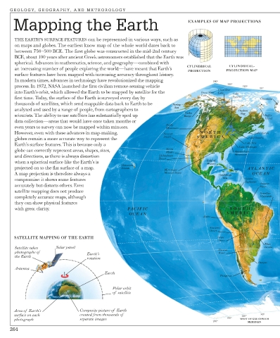
      Mapping the Earth                                                    EXAMPLES OF MAP PROJECTIONS


       THE EARTH’S SURFACE FEATURES can be represented in various ways, such as
       on maps and globes. The earliest know map of the whole world dates back to
       between 750–500 BCE. The first globe was constructed in the mid-2nd century
       BCE, about 100 years after ancient Greek astronomers established that the Earth was
       spherical. Advances in mathematics, science, and geography—combined with
                                                                           CYLINDRICAL     CYLINDRICAL-
       an increasing number of people exploring the world—have meant that Earth’s
                                                                           PROJECTION     PROJECTION MAP
       surface features have been mapped with increasing accuracy throughout history.
       In modern times, advances in technology have revolutionized the mapping       180o
                                                                                           150o
       process. In 1972, NASA launched the first civilian remote-sensing vehicle                 120o
                                                                                       Great Bear       90o
       into Earth’s orbit, which allowed the Earth to be mapped by satellite for the   Great Slave  Lake  Lake
                                                                                Lake         Superior
       first time. Today, the surface of the Earth is surveyed every day by                             Greenland
       thousands of satellites, which send mappable data back to Earth to be   Bering
       analyzed and used by a range of people, from cartographers to   Sea                     Hudson
                                                                          Alaska                Bay
       scientists. The ability to use satellites has substantially sped up   Range                        Baffin
                                                                                                          Island
       data collection—areas that would have once taken months or
                                                                   Rocky
       even years to survey can now be mapped within minutes.      Mountains
       However, even with these advances in map-making,           Sonoran       NOR TH                Lake Huron
                                                                  Desert       AMERICA
       globes remain a more accurate way to represent the                                          Lake Ontario
       Earth’s surface features. This is because only a                                           Lake Erie
                                                                                               Lake Michigan
       globe can correctly represent areas, shapes, sizes,         Sierra                     Appalachian
                                                                   Madre
       and directions, as there is always distortion            Chihuahuan                    Mountains
                                                                Desert
       when a spherical surface like the Earth’s is                                Gulf of
                                                                                   Mexico
                                                 Hawaiian
       projected on to the flat surface of a map.    Islands      Mississippi-                     ATLANTIC
       A map projection is therefore always a                     Missouri River       Caribbean    OCEAN
       compromise: it shows some features                                                Sea      Guiana
                                                                                                  Highlands
       accurately but distorts others. Even                                                             Amazon
                                                                                                        River
       satellite mapping does not produce
                                                                                                        Brazilian
       completely accurate maps, although                                                               Highlands
       they can show physical features
       with great clarity.                         PACIFIC                                  SOUTH
                                                    OCEAN                                 AMERICA
                                                                                 Andes
                                                                                    Atacama
                                                                                    Desert
       SATELLITE MAPPING OF THE EARTH                                                  Gran
                                                                                       Chaco
                                                                                                          Mato
       Satellite takes   Solar panel                                                   Parana             Grosso
       photographs of              Earth’s                                             River
       the Earth
                                   rotation
                                                                                                       Pampas
       Antenna
                                          Earth
                                                                                        Patagonia
                                             Polar orbit
                                             of  satellite
       Area of  Earth’s         Composite picture of  Earth
       surface on each          created from thousands of                                       120o    90o
       photograph               separate images                                           150o  WEST OF GREENWICH
                                                                                     180o
                                                                                                   MERIDIAN
     264
   261   262   263   264   265   266   267   268   269   270   271