
Page 258 - (DK Eyewitness) Travel Guide - Austria
P. 258
256 A USTRIA REGION B Y REGION
u Ötztal
Road map B4. £ @
n Gemeindestrasse 4, Sölden
(05720) 05 00. ∑ oetztal.com
Following the course of the
Ötztaler Ache, a tributary of the
Inn river, is the long valley of
Ötztal. At its southern end, near
the border with Italy, rise the
Ötztal Alps, with many peaks
above 3,500 m (11,500 ft); the
Wildspitze, at 3,774 m (12,381 ft),
is North Tyrol’s highest summit.
Nestling within the Ötztal
Alps is also the highest parish
in Austria, the ski resort of
Obergurgl at 1,927 m (6,322 ft).
The largest settlement in the
lower part of Ötztal is Oetz,
an old village with attractive,
colourful houses. The paintings
on the Star Inn date from 1573
and 1615. On a steep slope
stands the church of St George
and St Nicholas, which retains
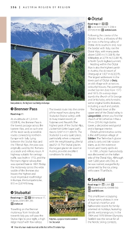
Europabrücke, the highest road bridge in Europe some original Gothic features,
including a vault and portals.
t Brenner Pass The lowest route into the centre The largest town at the
of the massif runs along the upper end of the Ötztal valley is
Road map B5.
Stubaital (Stubai valley), with Längenfeld, where you find the
At an altitude of 1,374 m its busy tourist resorts of church of St Catherine. It has a
(4,508 ft), the Brenner Pass is Fulpmes and Neustift. The 74-m- (243-ft-) high Gothic
the lowest passage across the highest peak of the Stubai Alps, tower, a decorative west portal
Eastern Alps, and as such one Zuckerhütl (Little Sugar Loaf), and a Baroque interior.
of the most easily accessible rises to 3,507 m (11,506 ft). The Ötztal’s administrative centre
routes connecting northern Stubaital is a very quiet place, is the old Tyrolean village of
Europe with Italy. Lying particularly when compared Sölden. The Tiefenbach glacier
between the Stubai Alps and with the neighbour ing Zillertal attracts early and late-season
the Zillertal Alps, the pass was (pp252–3). The Stubai glacier, skiers, as do the extensive
originally used by the Romans the largest glacier ski resort in terrain and hearty après-ski.
as a trade and military route. A Austria, provides excellent In 1991, a frozen human body
highway suitable for carriage conditions for skiing. was discovered on the Italian
traffic was built in 1772, and the side of the Ötztal Alps. Although
first trans-Alpine railway line over 5,000 years old, Ötzi, as
was opened here in 1867. Today he was named, was perfectly
the motor way across the wide preserved by the ice, along
saddle of the Brenner also with some 70 artifacts.
boasts the highest and
most impressive road bridge
in Europe, the Europabrücke, i Seefeld
815 m (2,674 ft) long. Road map B4. * 3,300. £
n Klosterstrasse 43, (05088) 050.
y Stubaital ∑ seefeld.com
This small town occupying
Road map B4. @ n Bahnstrasse 17,
Fulpmes, (0501) 881 200. a large sunny plateau is one
∑ stubai.at of Austria’s most fun and
fashionable resorts for family-
Travelling on the Brenner oriented ski holidays, featuring
motorway from Innsbruck gentle, welcoming runs. In the
towards Italy you will pass the 1964 and 1976 Winter Olympics,
Stubai Alps to your right, a high Fulpmes, a popular tourist centre in Seefeld was the venue for all
ridge massif with few valleys. the Stubaital the Nordic skiing contests,
View of a man-made reservoir at the foot of the Zillertaler Alps
256-257_EW_Austria.indd 256 12/09/17 3:04 pm
Eyewitness Travel LAYERS PRINTED:
Catalogue template “UK” LAYER
(Source v2.1)
Date 5th December 2012
Size 125mm x 217mm