
Page 9 - (DK Eyewitness) Travel Guide - Argentina
P. 9
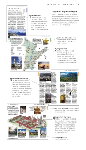
HOW T O USE THIS GUIDE 7
ARGENTINA REGION B Y REGION 261
TIERRA DEL FUEGO
AND ANTARCTICA
The remote archipelago of Tierra del Fuego really does feel like Argentina Region by Region
el fin del mundo – the end of the world – where the great Andean
mountain range finally meets the sea. Only the continent of Antarctica
lies beyond, and the area serves as the main jumping-off point for
intrepid travelers eager to glimpse this sparkling, shifting mass of Apart from Buenos Aires, Argentina
blue and white ice, the world’s last great wilderness. Introduction
Tierra del Fuego is separated from the rest Darwin, before Anglican missionaries has been divided into six regions: the
of South America by the Strait of Magellan. became the first outsiders to settle the
The archipelago consists of a main island, region in 1871, near the present-day city 1The landscape, history
Isla Grande, and a group of smaller islands. of Ushuaia. Sheep farmers followed,
Its land mass is divided equally between together with further missionaries in the Pampas; Argentinian Litoral; Córdoba
Argentina and Chile, the border between form of the Salesians of Don Bosco, who and character of each
the two countries running from the Strait established their mission near what is now
in the north to Canal Beagle in the south. Río Grande, the region’s biggest city. and the Andean Northwest; Cuyo and
The Strait is named for Portuguese Antarctica, the world’s coldest and driest region is described here,
explorer Ferdinand Magellan, who continent, sits 620 miles (1,000 km) across
became the first European to discover the Drake Passage from Ushuaia. For the Wine Country; Patagonia; Tierra
the archipelago, in 1520. He called it centuries a source of mystery – the ancient showing how the area
Tierra del Fuego (Land of Fire) for the Greeks thought it a populated and fertile
numerous fires he witnessed along its land, only blocked by monsters – the del Fuego and Antarctica.
coastline, warning signals from one continent was not discovered until the has developed over the
indigenous tribe to another that 1820s. Today, Antarctica is experiencing a
something unusual had arrived. tourist boom, with up to 30,000 visitors
The Selknam, Kaweskar, Manekenk, drawn each year to its silent world of centuries and what it
and Yámana tribes would later draw the icebergs and glaciers, a haven for an
attention of English naturalist Charles astonishing array of marine fauna.
offers to the visitor today.
162 ARGENTINA REGION B Y REGION ARGENTINIAN LIT OR AL 163
Each region of Argentina can be
Exploring Argentinian Litoral General Getting Around
Enrique Mosconi The area’s main airports are at Rosario, Corrientes,
Stunning natural highlights and historical architecture are the Tartagal Resistencia, and Puerto Iguazú. There are regular identified quickly by its own color
Cormorants crowding the rocks on an island in Canal Beagle, near Ushuaia Ingr. Guillermo flights that connect Paraná and Resistencia to
main tourist attractions of the region. Palm-fringed beaches
Ice cave formed by collapse of a glacial wall N. Juárez Buenos Aires. A reliable option is the long-distance coding, which is shown on the
edge the islands and banks of Ríos Paraná and Uruguay. Some
buses that link the main towns and cities. Motorists
of the best beaches can be found at Rosario, Colón, and Laguna following the course of Río Paraná via Ruta Provincial
Gualeguaychú. The region’s biggest city, Rosario, brims with Complejo Hídrico Yerma 11 and Ruta Nacional 12 should note that main
R. Teuco-Lag. Yema
museums, galleries, and monumental architecture. Santa Fe FORMOSA river crossings are via the Rosario–Victoria and inside front cover.
and Corrientes have beautifully preserved colonial streets, Río Pilcomayo Corrientes–Resistencia road bridges, and
and San Ignacio Miní houses 300-year-old Jesuit ruins. Río Porteno the Sante Fe–Paraná subfluvial tunnel.
Off-the-beaten-track destinations include Yapeyú, the G r a n C h a c o Laguna Blanca An effigy at the Carnaval celebrated in
birthplace of General San Martín, and Mercedes, CHACO Río Bermejo PARQUE NACIONAL
gateway to the vast Esteros del Iberá. RĺO PILCOMAYO Asunción Gualeguaychú, Entre Ríos
Pirané
Castelli Río Guaycurú Río Riacho Pilagá
Sights at a Glance Puerto Iguazú PARQUE
Towns and Cities National Parks and Preserves Tres Isletas San Francisco Formosa Río Paraguay NACIONAL
IGUAZÚ
1 Rosario pp164–5 2 Parque Nacional Pre-Delta Salta Presidencia de Laishi
Roque
3 Paraná 8 Parque Nacional El Palmar Campo Largo Sáenz Peña El Dorado Bernardo Regional Map
4 Santa Fe q Esteros del Iberá pp170–71 Las Breñas PARQUE NACIONAL Montecarlo de Irigoyen
CHACO
5 Gualeguaychú r Parque Nacional Chaco San Pedro
7 Colón t Parque Nacional Río Pilcomayo General Pinedo Berthet Villa RESISTENCIA Itatí IGNACIO MINĺ SAN MISIONES 2This shows the main road
u Parque Nacional Iguazú pp176–9
9 Yapeyú Río Paraná Yacyretá Posadas Campo
0 Mercedes Villa Angela Charadai CORRIENTES Berón de Dam Grande
w Corrientes Santa Sylvania Empedrado Estrada Ituzaingo Oberá El Soberbio
e Resistencia San Javier network and gives an
Historical Buildings 0 kilometers 100 SANTA FE Saladas Río del Sta. Lucía San Miguel ESTEROS Río Uruguay
DEL IBERÁ
6 Palacio San José 0 miles 100
y San Ignacio Miní San Roque L. del Iberá illustrated overview of the
Añatuya Río Paraná CORRIENTES Santo Tomé Key
Tostado Reconquista MERCEDES Alvear Expressway
Vera Highway whole area. All interesting
YAPEYÚ Main road
Ceres Curuzú Cuatia Paso de Minor road
Esquina Los Libres
San Cristóbal Río Guayguiraró Sauce Río Mocoretá Monte Railroad places to visit are numbered
International border
San Javier San José Caseros Provincial border
San Justo La Paz de Feliciano and there are also useful tips
Federal
Rafaela Helvecia ENTRE RÍOS Emb. Salto Grande
Córdoba Concordia on getting around the region.
SANTA FE
PARANÁ PARQUE
NACIONAL
Diamante EL PALMAR
PARQUE PALACIO
SAN JOSÉ
NACIONAL
Córdoba COLÓN
San PRE-DELTA
Lorenzo Río Gualeguaychú Concepción
del Uruguay
ROSARIO
Río
Cuarto
GUALEGUAYCHÚ
Melincué San Nicolás Médanos
Río Paraná
Venado de Los Arroyos Río Uruguay
Cathedral on Plaza Primero de Mayo, Paraná Tuerto View of a beautiful sunset over the Río Paraná, Corrientes
Lag.
Rufino La Picasa
For keys to map symbols see back flap Junín 204 ARGENTINA REGION B Y REGION C ÓRDOBA AND THE ANDEAN NOR THWEST 205
f Monumento
Natural Laguna de
los Pozuelos
Road map B1. 30 miles (48km) NW
of Iruya. Tel (03887) 491-349. @ n
Macedonio Gras 141, Abra Pampa,
(0388) 491-349. Open 8am–3pm daily.
by prior arrangement.
Situated in a natural basin
Detailed Information and Sierra de Rinconada, this
between Sierra de Cochinoca
remote wildlife preserve rises
11,810 ft (3,600 m) above sea
3All the important towns 58 sq miles (153 sq km), the
level. Spread over an area of
park is one of the most import-
The picturesque Humahuaca nestled in the Andean hills ant wetlands in South America.
and other places to visit are Humahuaca Iruya 44 miles (70 km) N of Humahuaca. Although it has shrunk in Sweeping view of towering peaks covered in verdant yunga forest, Parque Nacional Calilegua
recent years after a few dry
78 miles (125 km) N of Jujuy. *
El Rey
now an interesting museum
12,000. @ Iglesia de la Candelaria y * 1,200. @ ∑ iruyaonline.com summers, the park’s lagoon Tojo, still stands and is h Parque Nacional j Parque Nacional
Calilegua
still takes up about half the
San Antonio Buenos Aires 383. Open
described individually. They 9:30am–noon & 4–7pm Mon–Fri. Overlooking the river of the total area. It is the habitat of exhibiting some of the ruling Road map B1. 75 miles (120 km) NE Road map C1. 155 miles (250 km) SE
same name, Iruya is a beautiful
dynasty’s memo rabilia.
large flocks of Andean
∑ ciudadhumahuaca.com
Andean hamlet located 9,120 ft
Standing next to it is a
of Jujuy. Tel (03487) 4312-683. @
flamingos and numerous other
of Jujuy. Tel (03886) 422-046. @
(2,780 m) above sea level. Time
species of wildfowl including
Open 9am−dusk Mon–Sat.
Open 9am−6pm daily. 8
Founded in 1591, Humahuaca
17th-century church, Iglesia
are listed in order, following is the largest town between seems to pass slowly here, and teals and avocets. Shy ñandús de Nuestra Señora del Rosario ∑ parquesnacionales.gob.ar ∑ parquesnacionales.gob.ar
the fortified walls, cobblestoned
y San Francisco. Behind its
San Salvador de Jujuy and
(lesser rheas) can also be
streets, and whitewashed adobe
Created in 1948, Parque
whitewashed façade are the
the Bolivian border. It has a
spotted scuttling away for cover.
Comprising over 290 sq miles
The best way to observe these
region’s best-preserved colonial
picturesque town center, and its
(763 sq km) of subtropical
dwellings are much as they
Nacional El Rey is one of three
the numbering on the Regional narrow, roughly paved streets have always been. birds at close quarters is by interiors, complete with a yunga forests, lakes, and rivers, cloud forest parks in northwest
Argentina, the others being
The village’s focal point is its
Parque Nacional Calilegua is the
and rustic adobe houses are
wonderfully ornate Baroque
walking through the park from
church, the colonial Iglesia de
Calilegua and Baritú to the
largest of the national parks in
classically Andean.
pulpit. The interior would be
its entrance rather than driving.
The town’s star attraction is Nuestra Señora del Rosario y The park can be accessed at any even more impressive had not northwest Argentina. Thanks to north. It rises to an average of
Map. Within each town or city, Iglesia de la Candelaria y San San Roque. Here, on the first time but it is advisable to drop some of the church’s treasures its easy accessibility, it is also the 2,950 ft (900 m) above
Sunday of October, the feast of
been looted during the border
in at the guardería (ranger
most visited. The park is the
sea level and the
Antonio, also a National
peaks are usually
disputes with Chile in the late
Our Lady of the Rosary is held, a
Historical Monument. This
setting for Gerald Durrell’s
station), which is located on
striking white church was built surreal procession of masked the south side of the lake, for a 1970s. The windows are popular 1960s book The enveloped in thick
there is detailed information by the Jesuits toward the end figures that blends elements chat with the knowledgeable perhaps the most unusual Whispering Land. plant life lush and green even
cloud, keeping most of the
of the 17th century, and has
Parque Nacional
and welcom ing guardaparques
from Easter festivals and pre-
feature, as their panes are made
undergone extensive
in the drier months. Pre viously
of wafer-thin onyx, casting a
Calilegua is easy to
conquest animistic rituals.
(park rangers).
restoration after it was largely surreal, yellow-orange glow navigate with many a private estate, the park
on important buildings and destroyed by an earthquake in g Yavi over the nave. trails that weave now pro tects 155 sq miles
1873. The interior is richly
(408 sq km) of yunga forests.
through dense
Strikingly diverse in both flora
ornamented, with two rococo
and tangled
Road map B1. 195 miles (314 km) N of
other sights. altarpieces depicting various Jujuy. * 300. @ cloud forest, Toucan in Parque and fauna, El Rey is home
often leading
Biblical events. Other art works
to a number of endangered
Nacional El Rey
in the church include the series
Another sleepy high-plains
mammals includ ing jaguars
above the tree
called The Twelve Prophets,
streets and adobe houses, Yavi
The avian population,
the high puna. As well as
completed in 1764 by well- hamlet of sloping cobble stoned line and to the drier prairies of and pumas.
known Cusco School artist also seems to have given diverse flora, which changes totalling over 150 species, is
Marcos Sapaca. moder nity the slip. The village according to the altitude and more visible and includes the
The handicraft shops in town, dates from the late 17th century humidity, brown eagles, condors, emblematic giant toucan and
well-stocked with souvenirs, when nobleman Juan and northern huemul deer can several species of parrot and
and the tiny folk music venues Fernández Campero, the first also be seen. Jaguars and pumas eagle. Numerous footpaths
are highly popular with tourists. Marqués del Valle del Tojo in roam the forests, though both and one major vehicle trail
Humahuaca is also a good Spain, married into the area’s species have a well-founded snake around the park from
base from which to explore landholding family. In 1708, fear of humans. Mornings and the visitor center. The best trail
the haunting land scapes of Spain’s King Phillip V named him evenings are the best times to for bird-watchers is the 8-mile
Puna Jujeña, an area of wild Marqués of Tojo, a unique honor see these animals. Visitors can (13-km) Senda Pozo Verde,
highland, lagoons filled with in colonial Argentina. The well- hire guides and also find useful which climbs through the
pink flamingos, and tiny mud- View of Iglesia de Nuestra Señora del preserved 18th-century family The 18th-century Casa del Marqués de Tojo, maps and information at the bird-filled forest to a small,
brick hamlets. Rosario y San Roque home, Casa del Marqués de now a museum park’s entrance. beautiful lake.
190 ARGENTINA REGION B Y REGION C ÓRDOBA AND THE ANDEAN NOR THWEST 191
For hotels and restaurants in this region see pp280–81 and pp293–4
8 Santa Catalina Above the main wooden VISITORS’ CHECKLIST
. Altar
A UNESCO World Heritage Site, this Jesuit estancia altar stands a gilded retablo Practical Information
(altarpiece) housing an
was founded in 1622. It became an important agri cul image of Saint Catherine Road Map C2. 13 miles (20 km) For all the top sights, a visitors’ checklist
N of Jesús María. Tel (03525) 428-
tural and sheep farming estab lish ment, yet its most (Santa Catalina). Other 505. Open Jan–Feb: 10am–1pm,
important func tion was as the provider of thousands wooden statues include 2:30–7pm Tue–Sun; Mar–Dec:
of mules for cargo trains traveling along the Camino de la Humilidad y la 10am–1pm, 3–6pm Tue–Sun. provides the practical information needed
one of the Señor
Real between Buenos Aires and Alto Perú (now Bolivia). Paciencia, and another of & 8 0 - =
∑ santacatalina.info
The exten sive site con tained workshops, a smithy, a the crucified Christ. Transport
carpen try, two flour mills, and a reser voir; there were @ to plan your visit.
also residences for priests, native laborers, and slaves.
Its soaring main church is one of the best examples Corridor characterized by plain brick walls
of colonial Baroque in the country. While it is now and curved ceiling
administered by the state in accordance with a
presi dential decree, Santa Catalina remains the
private property of the Díaz family. The cemetery is
where priests and
workers were buried,
some of whom had
spent their entire life Argentina’s Top Sights
at the estancia.
4Historic buildings are dis sected
to reveal their interiors; museums
and galleries have color-coded
floorplans; and national parks
have maps showing the main
points of interest. Major towns
have maps, with sights picked
out and described.
Rear Courtyard
The rear patio is surrounded by workshops and possibly
residences for laborers, though slaves were housed in a . Central Courtyard Front Courtyard . Church Façade
building apart from the main complex. The grandest of the three main patios, this is A quiet and plain patio, the front courtyard would have The high and elegant white façade
enclosed by a vaulted gallery and has a central been used by the Jesuit priests to receive deliveries has two towers and curved pediments Story boxes explore
fountain. Cloisters and workshops occupy the from the neighboring towns as well as for non- framing the doorway, typical of the
rooms along the sides. ecclesiastical gatherings. Baroque school of architecture.
specific subjects further.
For hotels and restaurants in this region see pp280–81 and pp293–4
006-007_EW_Argentina.indd 7 05/08/16 10:03 am