
Page 261 - (DK Eyewitness) Travel Guide - Australia
P. 261
NOR THERN QUEENSLAND 259
after its first European settlers, qMission Beach
John and Kate Atherton, who £ Tully. @ Mission Beach. g Mission
established a cattle station here Beach. n Mission Beach (07) 4068
in the mid-19th century. The 7099. ∑ missionbeachtourism.com
wealthy agricultural centre of
Mareeba now stands on the site Located halfway between
of this former ranch. Cairns and Townsville, Mission
Beach comprises four beach
villages linked by 14 km
9Wooroonooran (9 miles) of golden sand in an
National Park unspoilt, natural environment.
Its boutiques, galleries and
£ Innisfail. @ Innisfail. n ANZAC restaurants are set against a
Memorial Park, cnr Gladdy St & Bruce rainforest backdrop and views
Highway 0428 228 962, or Cardwell across to nearby Dunk Island,
Visitor Information (07) 4066 2412.
∑ npsr.qld.gov.au/parks/ just 4 km (2.5 miles) off the
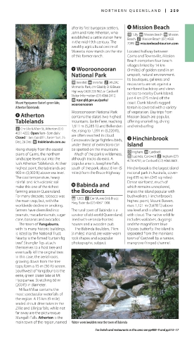
Mount Hypipamee Crater’s green lake, wooroonooran coast. Dunk Island’s rugged
Atherton Tablelands terrain is covered with a variety
Wooroonooran National Park of vegetation. Day trips from
8Atherton contains the state’s two highest Mission Beach are popular,
Tablelands mountains. Bartle Frere, reaching offering snorkelling, diving
1,611 m (5,285 ft) and Bellenden and windsurfing.
n Cnr Silo & Main St, Atherton (07) Ker, rising to 1,591 m (5,220 ft),
4091 4222. Open 9am–5pm daily.
Closed 1 Jan, Good Fri, Easter Sun, 25 are often swathed in cloud. wHinchinbrook
Dec, 26 Dec. ∑ itablelands.com.au Cassowaries (large flightless birds,
under threat of extinction) can Island
Rising sharply from the coastal be spotted on the mountains. £ Ingham. @ Cardwell.
plains of Cairns, the northern Much of the park is wilderness, g Lucinda, Cardwell. n Ingham (07)
landscape levels out into the although tracks do exist. A 4776 4792, or Cardwell (07) 4066 8601.
lush Atherton Tablelands. At their popular area is Josephine Falls,
highest point, the tablelands are south of the park, about 8 km (5 Hinchinbrook is the largest island
900 m (3,000 ft) above sea level. miles) from the Bruce Highway. national park in Australia, cover-
The cool temperature, heavy ing 635 sq km (245 sq miles).
rainfall and rich volcanic soil 0Babinda and Dense rainforest, much of
make this one of the richest which remains unexplored,
farming areas in Queensland. the Boulders makes the island popular with
For many decades, tobacco was * 1,300. n Cnr Munro St & Bruce bushwalkers. Hinchinbrook’s
the main crop, but, with the Hwy, Babinda (07) 4067 1008. highest point, Mount Bowen,
worldwide decline in smoking, rises 1,121 m (3,678 ft) above
farmers have diversified into The rural town of Babinda is a sea level and is often capped
peanuts, macadamia nuts, sugar survivor of old-world Queensland, with cloud. The native wildlife
cane, bananas and avocados. lined with veranda-fronted includes wallabies, dugongs
The town of Yungaburra, houses and a wooden pub. and the magnificent blue
with its many historic buildings, The Babinda Boulders, 7 km Ulysses butterfly. The island is
is listed by the National Trust. (4 miles) inland, are water-worn separated from the mainland
Nearby is the famed “curtain fig rock shapes and a popular town of Cardwell by a narrow,
tree”. Strangler figs attach photographic subject. mangrove-fringed channel.
themselves to a host tree and
eventually kill the original tree.
In this case, the aerial roots,
growing down from the tree
tops, form a 15-m (50-ft) screen.
Southwest of Yungaburra is the
eerie, green crater lake at Mt
Hypipamee. Stretching 60 m
(200 ft) in diameter.
Millaa Millaa contains the
most spectacular waterfalls of
the region. A 15-km (9-mile)
sealed circuit drive takes in the
Zillie and Ellinjaa falls, while not
far away are the picturesque
Mungalli Falls. Atherton is the
main town of the region, named Water-worn boulders near the town of Babinda
For hotels and restaurants in this area see pp488–9 and pp515–17