
Page 334 - (DK Eyewitness) Travel Guide - Australia
P. 334
332 WESTERN A USTR ALIA
8Ningaloo Reef Lighthouse, on a high bluff
Marine Park offering striking, panoramic views
across the entire peninsula.
@ Exmouth. n Milyering Discovery
Centre, Yardie Creek Rd, Cape Range Environs
National Park (08) 9949 2808. Open Cape Range National Park
9am–3:45pm daily. Closed 25 Dec.
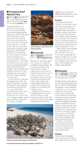
contains a low mountain range
This marine park runs for with spectacular gorges and
260 km (162 miles) along rocky outcrops. This area was
the west coast of Exmouth originally under water and it is
Peninsula and around the tip possible to discern the fossils of
into Exmouth Gulf. The Ningaloo ancient coral in the limestone.
Reef is the largest fringing Local wildlife includes kangaroos,
barrier reef in the state and emus and large lizards. There are
offers many of the attractions two main wilderness walks, but
of the east coast’s Great Barrier visitors should not attempt these
Reef (see pp216–21)eef (see pp216–21)eef . In many in summer as temperatures can
R R
places, it lies very close to the Yardie Creek Gorge in Cape Range National reach as high as 50°C (120°F).
shore, and its turquoise waters Park, near Exmouth Yardie Creek is on the western
are popular with snorkellers. side of the park, only 1 km
Apart from numerous types 9Exmouth (0.5 miles) from the ocean.
of coral and brightly coloured * 2,200. ~ @ n Murat Rd (08) A short walk along gorge cliffs
fish, the marine park also 9949 1176. ∑ visitningaloo.com.au leads to the spectacular canyon,
protects a num ber of species. where you may catch sight of
Several beaches at the northern Situated on the eastern side of rock wallabies on the far canyon
end of the park are used by sea the Exmouth Peninsula, this wall. A cruise through the
turtles as mating and breeding small town was originally built gorges is also available.
areas. Further offshore, it is in 1967 to service the local
possible to see the gentle whale airforce base. A military
shark from late March to May. presence is still very much in 0Dampier
Capable of growing to up to evidence, but today the town is * 1,400. ~ @ n Lot 4548 De Witt
18 m (60 ft), this is the largest more important as a tourist Road, Karratha (08) 9144 4600. Open
fish in the world. destination, used as a base for 9am–4pm Mon–Sat (to 1pm Sat).
The best areas for snorkelling exploring the Ningaloo Reef
are Turquoise Bay or the still Marine Park and the Cape Dampier stands on King Bay on
waters of Coral Bay. A number Range National Park. Giant the Burrup Peninsula, facing the
of companies offer organized turtles and whale sharks can 40 or so islands of the Dampier
scuba diving outings. Visitors frequently be seen from the Archipelago. It was established
can camp on the park’s nearby coastline. and still acts as a service centre
coastline at several sites mana Slightly outside of town, at and port for mining areas
ged by the Department of Vlaming Head, lies the wreck inland; natural gas from the
Environment and Conservation of the SS Mildura, a cattle nearby Northwest Shelf Project
(DEC). Fishing is another popular transporter which sank in 1907 is processed here for domestic
pursuit here, but catches are and is still visible from the shore. and export markets. The town
very strictly controlled. Nearby stands the Vlaming also has the largest desalination
plant in Australia. This can be
viewed from the Dampier Solar
Evaporated Salt Mine Lookout.
Dampier is also a popular base
for offshore and beach anglers.
Every August, gamefishing
enthusiasts converge on the
town for the Dampier Classic
and Game Fishing Classic.
The Burrup Peninsula is
one of the most renowned
ancient Aboriginal art sites
in Australia, created by the
Yapurrara Aborigines.
Environs
The Dampier Archipelago,
within 45 km (28 miles) of the
White sands of Turquoise Bay in Ningaloo Reef Marine Park town, offers a range of activities
For hotels and restaurants in this area see pp490–91 and pp521–2