
Page 234 - (DK Eyewitness) Travel Guide - Canada
P. 234
36 Welland Canal was built to solve the problem
Lake Superior of Niagara Falls. The Falls presented an
obstacle that prevented boats from passing
n Ontario Travel between lakes Ontario and Erie.
Information Centre, Sault
Ste. Marie; (705) 945 6941
The least polluted and most sticks out into Lake Erie for the boardwalk, and there is
12 miles (20 km) and forms
westerly of the Great Lakes,
also a concession stand.
EXPERIENCE Ontario largest body of fresh water, Canada’s mainland. The park visitor center features displays
Lake Superior is the world’s
the southernmost tip of
Farther into the park, the
has a wide variety of habitats,
of local flora and fauna.
with a surface area of 31,700
including marsh lands, open
sq miles (82,000 sq km). It is
fields, and ancient deciduous
known for sudden violent
forest. These woods are a
storms, long a source of dread
to local sailors. The lake’s
Georgian Bay Islands
northern coast is a vast
few places in North America’s
National Park
weather-swept stretch of wild- rarity, as they are one of the 38 "
Carolinian Life Zone, where
erness, domi nated by granite many of the trees have never ⌂ Beausoleil Island § (705)
outcrops and seemingly been logged. The profusion of 527 7200 g DayTripper:
limitless forest. This species creates a junglelike (705) 526 8907 # Times
challenging area is best atmo sphere, with red cedar, vary, call ahead
experienced in Pukaskwa black walnut, white sassafras,
National Park and Lake hickory, sycamore, and sumac, The waters of Georgian Bay
Superior Provincial Park, both all struggling to reach the light. are dotted with thousands of
reached via the Trans-Canada This varied vegetation little islands, often no more
Highway (Hwy 17), as it cuts a attracts thousands of birds, than a chunk of rock guarded
dramatic route along the which visit on their spring by a windblown pine. The bay
lake’s north shore. and fall migrations. Over 370 is large, beautiful, and flows
species have been sighted into Lake Huron. Sixty of its
here, and they can be islands have been incorpo-
observed from lookout points rated into the Georgian Bay
37 "' and forest trails. Every fall, Islands National Park. The
Point Pelee hosts of orange-and-black park’s center is Beausoleil
National Park monarch butterflies can also Island, the hub of the area’s
be seen here. wide range of facilities.
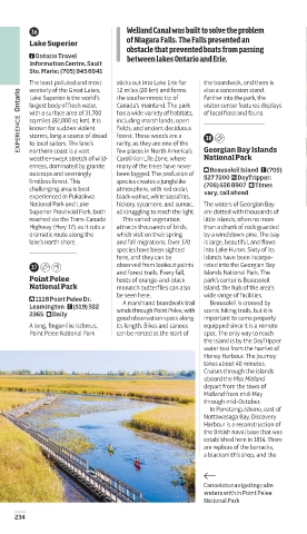
⌂ 1118 Point Pelee Dr, A marsh land boardwalk trail Beausoleil is crossed by
Leamington § (519) 322
2365 # Daily winds through Point Pelee, with scenic hiking trails, but it is
good observation spots along important to come properly
A long, finger-like isthmus, its length. Bikes and canoes equipped since it is a remote
Point Pelee National Park can be rented at the start of spot. The only way to reach
the island is by the DayTripper
water taxi from the hamlet of
Honey Harbour. The journey
takes about 40 minutes.
Cruises through the islands
aboard the Miss Midland
depart from the town of
Midland from mid-May
through mid-October.
In Penetanguishene, east of
Nottawasaga Bay, Discovery
Harbour is a recon struction of
the British naval base that was
established here in 1814. There
are replicas of the barracks,
a blacksmith’s shop, and the
Canoeists navigating calm
waters within Point Pelee
National Park
234
234-235_EW_Canada.indd 234 28/01/2019 14:45
EW Catalogue template v3.0 – 12th July 2018
Fonts: Aptifer Sans LT Pro, Posterama Text, Soho Gothic
Pro, Soho Pro, ITC Caslon 224