
Page 176 - (DK Eyewitness) Travel Guide - Ireland
P. 176
174 IRELAND REGION B Y REGION
i Baltimore
Road map B6. Co Cork. * 300.
@ g to Sherkin Island (087 911
7377) ∑ sherkinisland.ie/eu; to
Cape Clear Island (028 39159).
∑ cailinoir.com
Baltimore’s most bizarre claim to
fame dates back to 1631 when
more than 100 citizens were
carried off as slaves by Algerian
pirates. Now that the threat
of being kidnapped has gone,
this village appeals to the
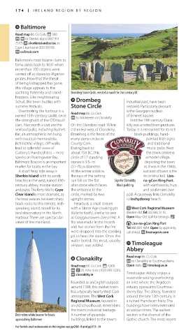
yachting fraternity and island- Drombeg Stone Circle, erected around the 2nd century BC
hoppers. Like neigh bouring o Drombeg
Schull, the town bustles with industrial past, have been
summer festivals. Stone Circle restored. Particularly pleasant
Overlooking the harbour is a Road map B6. Co Cork. is the Georgian nucleus
ruined 15th-century castle, once @ to Skibbereen or Clonakilty. of Emmet Square.
the stronghold of the O’Driscoll Until the 19th century Clona-
clan. Also worth a visit are the On the Glandore road 16 km kilty was a noted linen producer.
seafood pubs, including Bushe’s (10 miles) west of Clonakilty, Today, it is renown ed for its rich
Bar, an atmospheric inn hung Drombeg is the finest of the black pud dings, hand-
with nautical memorabilia. many stone circles in painted Irish signs
Behind the village, cliff walks County Cork. and traditional
lead to splendid views of Dating back to music pubs. Near
Carbery’s Hundred Isles – mere about 150 BC, this the town centre is
specks on Roaringwater Bay. circle of 17 standing a model village,
Baltimore Beacon is an important stones is 9.5- m depicting the town
marker for boats in the bay. (31- ft) in diameter. as it was in the 1940s.
A short ferry ride away is At the winter solstice, Just east of town is the
Sherkin Island with its sandy the rays of the setting recon structed Lios-
beaches in the west, ruined 15th- sun fall on the flat Sign for Clonakilty na-gCon Ring Fort,
century abbey, marine station altar stone which faces black pudding with earthworks, huts
and pubs. The ferry ride to Cape the entrance to the and souterrains (see
Clear Island is more dramatic, as circle, marked by two p24). A cause way links Clonakilty
the boat weaves between sharp upright stones. to Inchydoney beach.
black rocks to this remote, Irish- Nearby is a small stream
speaking island, noted for its with a Stone Age cooking pit E West Cork Regional Museum
bird observatory in the North (fulacht fiadh), similar to one Western Rd. Tel 023 883 3115.
Harbour. There are spectacular at Craggaunowen (see p194). A Open May–Oct (call for timings). &
views of the mainland. fire was made in the hearth T Lios-na-gCon Ring Fort
and hot stones from the fire Tel 086 059 1854. Open by appt only;
were dropped into the cook ing call ahead. ∑ liosnagcon.com
pit to heat the water. Once the
water boiled, the meat, usually a Timoleague
venison, was added.
Abbey
p Clonakilty Road map B6. Co Cork.
@ to Clonakilty or Courtmacsherry.
Road map B6. Co Cork. * 4,000. Open daily. ∑ timoleague.ie
@ n 25 Ashe Street (023 883 3226).
∑ clonakilty.ie Timoleague Abbey enjoys a
waterside setting overlooking
Founded as an English outpost an inlet where the Argideen
around 1588, this market town estuary opens into Courtmac-
has a typically hearty West Cork sherry Bay. The abbey, founded
atmosphere. The West Cork around the late 13th century, is
Regional Museum, housed in a ruined Franciscan friary. The
an old schoolhouse, remembers build ings have been extended
the town’s indus trial heritage. at various times. The earliest
Distinctive white beacon for boats A number of quayside section is the chancel of the
approaching Baltimore buildings, linked to the town’s Gothic church. The most recent
For hotels and restaurants in this region see pp298–9 and pp313–16
174-175_EW_Ireland.indd 174 08/03/17 11:06 am
Eyewitness Travel LAYERS PRINTED:
Catalogue template “UK” LAYER
(Source v1.9)
Date 20th August 2012
Size 125mm x 217mm