
Page 156 - (DK Eyewitness) Travel Guide - The Netherlands
P. 156
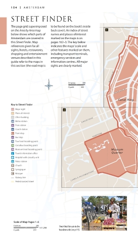
154 A MSTERD A M
STREET FINDER
The page grid superimposed to be found on the book’s inside
on the Area by Area map back cover). An index of street
below shows which parts of names and places of interest
Amsterdam are covered in marked on the maps is on
this Street Finder. Map pages 162–3. The key below
references given for all indicates the maps’ scale and
sights, hotels, restaurants, other features marked on them,
shopping and entertainment including transport terminals, H e t
venues described in this emergency services and I J
guide refer to the maps in information centres. All major
this section (the road map is sights are clearly marked.
NASSAUKADE HERENGRACHT DAMRAK
0 metres 500 Nieuwe
0 yards 500 Zijde
ROZENGRACHT DAM
Canal Ring Oude
Zijde VALKENBU RGERSTR
Key to Street Finder
Major sight
Place of interest
Other building PR I N S E N G R ACHT
Metro station KINKERSTRAAT PLANTAGE MIDDENLAAN
Train station
Coach station
Tram stop OVERTOOM A m s t e l MAU R I T S K A D E
Bus stop VIJZELSTRAAT
Tour boat boarding point
Canalbus boarding point LINNAEUSSTRAAT
Museum boat boarding point Museum
Tourist information office Quarter STA DHOU D ERSKADE
Hospital with casualty unit WIBAUTSTRAAT
Police station
Church
Synagogue
Mosque
Railway line CORNELIS KRUSEMANSTRAAT
Pedestrianized street
Scale of Map Pages 1–6
0 metres 250 Fresh fruit for sale in the
1:11,250
0 yards 250 Noordermarkt (see p115)
154-155_EW_Netherlands.indd 154 16/01/17 12:04 pm
Eyewitness Travel
Eyewitness Travel LAYERS PRINTED:
LAYERS PRINTED:
Flash template V2 (OpenType) “UK” LAYER
Streetfinder intro (Source v1)
“UK” LAYER
Date 7th August 2012
Date 10th November 2006
Size 125mm x 217mm
Size 125mm x 217mm