
Page 9 - (DK Eyewitness) Travel Guide - The Netherlands
P. 9
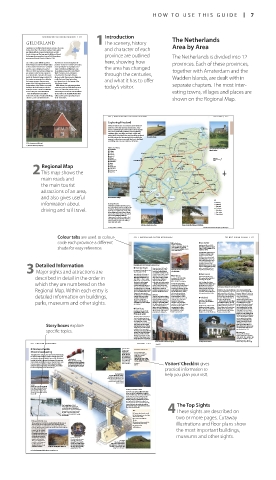
HOW T O USE THIS GUIDE 7
Introduction
NOR THERN AND EASTERN NE THERLANDS 335 The Netherlands
GELDERLAND 1The scenery, history
Gelderland is The Netherland’s largest province. Its name and character of each Area by Area
derives from the 11th-century county of Gelre, which
was linked with the town of Geldern, just over the
border in Germany. The town was the fiefdom of Gerard province are outlined
de Rossige, whose grandson Gerard II of Wassenberg The Netherlands is divided into 12
pronounced himself Count of Gelre in 1104.
Succeeding counts skilfully expanded that welcome visitors throughout the here, showing how provinces. Each of these provinces,
their territory to include the Veluwe region province. In more recent times, the region,
to the north, the Betuwe in the southwest and especially the strategically located the area has changed
and the county of Zutphen (see p345). towns of Arnhem and Nijmegen, saw
When in 1248 the imperial town of Nijmegen heavy fighting towards the end of World together with Amsterdam and the
was annexed, Gelre became a power to War II. The heroic action at Arnhem is through the centuries,
be reckoned with. A number of its towns remembered in the town’s Airborne
joined the Hanseatic League, and in 1339 Museum, while the museum in Nijmegen Wadden Islands, are dealt with in
the county was promoted to a duchy by recalls this town’s long history from and what it has to offer
the German emperor. The increasing pre-Roman times to the tyranny of the
power of the Habsburgs threatened the Holy Roman Empire.
independence of the Gelders, eventually While visitors can enjoy many modern today’s visitor. separate chapters. The most inter
leading to the duke having to cede the attractions, perhaps Gelderland’s greatest
territory in 1543 to Charles V. Gelderland asset is its contrasting natural scenery,
thus became part of the Netherlands. which ranges from heaths and woodlands esting towns, villages and places are
This colourful history is manifest in the north to the beautiful Betuwe river
today in the number of medieval buildings, valley and the pretty agricultural region
churches, castles and fortified towns of the Achterhoek. shown on the Regional Map.
296 NOR THERN AND EASTERN NE THERLANDS FRIESLAND 297
Exploring Friesland
Friesland is famous for its vast meadows and its distinctive
farmhouses of the kop-hals-romp and stelp types. It also
boasts a varied landscape. In the southwest are the popular Lauwersoog
Friese meren (Frisian lakes), while the north is typified by Anjum
undulating dykes, terp villages and church steeples with Holwerd Lauwers
pitched roofs. Gaasterland in the south has rolling woodlands Meer
and cliffs, whereas the Friese wouden (Frisian woods) in the The sea dyke at Wierum Ferwerd DOKKUM
province’s southeastern corner, with their forests, heathland
and drifting sands, are more reminiscent of Drenthe.
A 17th-century granary near Winterswijk Damwoude Kollum
St. Annaparochie
View of the old Dutch city of Nijmegen
Sights at a Glance Stiens Dokkumer Ee The terp of Hogbeintum, west of Dokkum, the
1 Leeuwarden Buitenpost highest in Friesland
2 Dokkum Veenwouden
3 Franeker Sexbierum Menaldum
4 Harlingen
5 Bolsward FRANEKER Dronrijp LEEUWARDEN Bergumer-
6 Workum Bergum Meer Surhuisterveen 0 kilometres 10
7 Hindeloopen HARLINGEN 0 miles 5
8 Gaasterland
9 Sloten
Regional Map 0 Sneek Wommels Wieuwerd Prinses Margriet Ka naal Earnewâld
OUDE VENEN
q Thialfstadion
e Beetsterzwaag
2This map shows the w Oude Venen Grou FRIESLAND Drachten
r Appelscha
Makkum BOLSWARD BEETSTERZWAAG
main roads and SNEEK Akkrum Donkerbroek
the main tourist WORKUM Joure Gorredijk Oosterwolde
attractions of an area, HINDELOOPEN Fluessen Heerenveen THIALFSTADION Oldeberkoop APPELSCHA
and also gives useful The Noorderhaven in Harlingen Stavoren Koudum Balk Sloter Meer SLOTEN Tjeukemeer Wolvega Noordwolde Key
information about Getting Around Rijsterbos GAASTERLAND Lemmer Motorway
Oudemirdum
Major road
Friesland is convenient and easy to get to. Minor road
It is crossed by the A7 (east–west) and the
driving and rail travel. A32 (north–south) motorways. Rail and Scenic route
bus links are unproblematic. Most of the
Main railway
larger villages and towns have a railway Minor railway
station; those which don’t can be reached Regional border
by bus. From Harlingen, Holwerd or
Lauwersoog, the islands are only a short
boat ride away. The province also has a
good network of minor roads, walking
routes and cycle tracks.
Gabled houses along Het Diep in Sloten Picturesque Lindevallei at Wolvega, near Thialfstadion
For map symbols see back flap For hotels and restaurants in this region see p399 and p413
Colour tabs are used to colour 276 NOR THERN AND EASTERN NE THERLANDS THE WEST FRISIAN ISLANDS 277
code each province a different E Oudheidkamer 4 De Slufter
Kogerstraat 1, Den Burg. Road Map B2. * none. g @
shade for easy reference. Tel 0222-313135. Open 1 Apr–31 Oct: Open all year, northern part closed
11am–5pm Mon–Fri, 2–4pm Sat.
1 Mar–1 Sep. n Emmalaan 66, Den
Closed 1 Jan, Easter, Whitsun, 25, 26 &
31 Dec, public hols. & Burg (0222-314741).
The distinctive natural area of
De Slufter, consisting of salt
marshes covering 450 ha
(1,100 acres), is covered with
salt-loving plants such as sea
thrift and sea lavender, and is
an important breeding and
Detailed Information Noorderhaaks, above sea level at high tide for some decades now different bird species. De Slufter,
feeding ground for many
and the neighbouring De Muy,
1 Noorderhaaks
where spoonbills breed, are
Kogerstraat runs the length
3 Major sights and attractions are Road Map B2. * none. n Emmalaan of the Binnenburg. Located Beachcomber on Texel, the most populated magnificent rambling areas.
here is the Oudheidkamer,
of the Frisian Islands
66, Den Burg (0222-314741).
an antiquities museum set up
5 Den Hoorn
Noorderhaaks, also known as
in a picturesque 16th-century
described in detail in the order in Razende Bol (raging ball), is a building, which used to be a 3 De Koog Road Map B2. * 450. g @
doss-house. Today it contains
fairly bleak sandbank west of
Road Map B2. * 1300. g @
n Emmalaan 66, Den Burg (0222-
Den Helder, 2.5 km (1.5 miles)
314741). ( Jul–Aug: Thu.
period rooms, a display of
n Emmalaan 66, Den Burg
offshore. The sea currents cause
artifacts and works of art
(0222–314741). ( Jul–Aug: Tue.
which they are numbered on the the island to shift eastwards in the attic, and a herb garden. In 1900, the former fishing Like Den Burg, Den Hoorn Salt-loving plants thriving at the water’s edge, De Slufter
Along and around the town
towards Texel, after which
stands on boulder clay. It has a
another “raging ball” appears at
wall are several interesting
distinctive Hervormde kerk
settlement of De Koog consisted
shopping streets, such as the
the same point off Den Helder.
of a church (built in 1415) and
(Protestant church) with a
Regional Map. Within each entry is The Dutch air force occasionally Weverstraat. A number of a few houses and farms. The first pointed steeple and church- Unlike the other islands, Vlieland 19th-century paintings. The
uses the island for target practice,
yard dating from 1425. This
tourist facility was the Badhotel,
excellent restaurants are to be
but it is not off-limits for visitors.
exquisitely restored village has
consists only of dunes, covered
later the Hotel Prinses Juliana,
houses are separated by alleys
found on the Warmoesstraat.
with a garden overlooking
Rowing and swimming here
been given protected status.
with a purple haze of heather,
known as “gloppen”. There is no
detailed information on buildings, are risky because of the powerful Environs the sea. Today, De Koog has 6 Vlieland marram grass and sea buckthorn. room for cars here, not even for
In the east, the woods planted
currents. Adventure-seekers
those of the islanders.
South of Den Burg is a sloping
accommodation for 20,000
regularly visit Noorderhaaks
just after 1900 provide a bit of
landscape with the 15 m (50 ft)
The best way to explore
visitors in hotels, pensions and
by boat or by helicopter,
variety in the landscape.
camp sites. The centre of De
Vlieland is by bicycle; the island
Hoge Berg (high mountain),
Road Map C1. * 1,000. g
parks, museums and other sights. unable to resist this piece of which offers a great view of the Koog is the Dorpsstraat, n Havenweg 10, Oost-Vlieland In the south is the only village, can be covered in one day. From
Oost-Vlieland, where the boat
total wilderness, where mirages
which has cafés, snack bars
Oost-Vlieland, you can cycle
(0562-451111).
island. For a good walk, follow
the Skille paadje from the tomb
from Harlingen docks. Many old
west wards along tracks through
and discos. De Koog’s attractions
are common.
of the Georgiers (resistance for visitors are the Calluna Vlieland is the smallest of the buildings line the main street. the dunes or along the Wadde-
fighters who died fighting the waterpark and EcoMare, Waddenzee Islands. In some One of them, the Tromp’s Huys nzee shoreline to the Posthuys
2 Den Burg Germans in 1945) to the fishing an information centre for places, less than one kilometre (1576), used to belong to the (post house), where in the 17th
village of Oudeschild, past the the Waddenzee and the (half a mile) separates the Amsterdam Admiralty. Today it century the overseas mail was
Road Map B2. * 6,000. g @ peat walls and sheep pens. North Sea (see p427). Waddenzee and the North Sea. houses a museum with brought from Amsterdam to be
n Emmalaan 66 (0222-314741). loaded onto ships waiting to sail.
( Mon am; Jul–Aug: Wed.
Further westwards is de Vliehors,
Den Burg is the main town of an area of natural interest which
Texel and situated right in its can be explored if no military
centre. Around 1300, the village exercises are taking place here.
was fortified by a circular Beware of get ting stuck in the
rampart with a moat, which are soft drifting sand. This is also
Story boxes explore now marked by the Burgwal where the wealthy village of
and Parkstraat Streets. A sheep
West-Vlieland once stood. It was
market was once held in April consumed by the waves after it
specific topics. and May at the Groeneplats, was abandoned in 1736.
Den Burg’s main square, with the
E Tromp’s Huys
present-day town hall. Today, a
sheep day is held on the first Dorpsstraat 99, Oost-Vlieland.
Monday of September. Further Tel 0562-451600. Open school hols:
on, by the Binnenburg, or inner 10am–5pm Tue–Fri, 2–5pm Sat, 2–4pm
castle, stands the 15th-century Sun; outside school hols: 2–5pm Tue–
Late Gothic Hervormde kerk Thu, 10am–1pm Fri, 2–5pm Sat.
(Protestant church). The The Nederlands-Hervormde church in Den Burg (1481) The village hall in Oost-Vlieland Closed 1 Jan, Easter, Pentecost. &
ZEELAND 251
250 WESTERN NE THERLANDS For hotels and restaurants in this region see pp398–9 and p412
1 Oosterschelde Concrete Piers VISITORS’ CHECKLIST
The piers were
Stormvloedkering made on the Practical Information
artificial island of
Throughout the centuries, the history of the Netherlands Neeltje Jans and Road Map A4–5. Deltapark
Neeltje Jans, Faelweg 5,
has been dominated by its people’s struggle against the then transported Vrouwenpolder.
by special barges
sea. After the disastrous floods of 1953, which hit Zeeland The Windsock to their destination. Open Apr–Oct: 10am–5:30pm
heavily, the battle to remove the danger of the sea once When the windsock is full, a This mighty task daily; Nov–Mar: 10am–5pm Wed,
Sat & Sun. & 7 - 0 =
and for all was undertaken in earnest. Now the Dutch seem warning is sounded, and people attracted a great Transport Visitors’ Checklist gives
deal of attention.
to have minimized the threat of flooding by building are advised to avoid driving over @ 133.
dykes and dams and closing off tidal inlets, all of which the dams and bridges between
the islands. Vigilance saves lives.
has had a major impact on the landscape.
practical information to
The Delta Works help you plan your visit.
The Delta Works have had far-
reaching consequences for the
landscape and environment. The
Zeeland islands, having been
joined to the mainland, are no
longer isolated.
Storms
Storms are a part of everyday life
in Zeeland: storms on the beach
or over the flat polders, storms Half-open Buttress Dam
which blow the cobwebs away
and storms which make you fear It took 13 years and €3.6 billion (two-thirds
for your life. of the cost of the Delta Works) to build the
Oosterschelde kering. After much deliberation,
the decision was made to keep open the
estuary and to preserve the salty estuary
habitat. A half-open multiple buttress dam
was built, with 62 sliding gates, which are
closed on average once a year during heavy
The Fateful Night of 1953 storms. This keeps the water salty and has The Top Sights
preserved the unique salt marshes and mud
On the night of 31 January 1953, flats of the Oosterschelde.
an event considered impossible in
modern times occurred. A combination
of spring tides and storms breached KEY 4These sights are described on
the dykes and washed them away 1 Concrete piers bear the sea wall.
as loose sand. A total of 1,835 people
lost their lives. 2 The sliding gates are closed only
when the water is high. two or more pages. Cutaway
3 A road has been built over
Deltapark Neeltje Jans the dam.
This attraction has been built on an artificial island, Neeltje Jans, on 4 Ground protection prevents the illustrations and floor plans show
earth from being washed away.
which the piers for the Oosterschelde Stormvloedkering (storm
surge barrier) were assembled, then taken by special barges to their 5 The piers rest on
positions. Now that task is finished, the island is being used mainly for solid foundations.
recreational and informative the most important buildings,
purposes. At the Deltapark
you can find out about the
Delta projects and about how
the barrier works. You can see museums and other sights.
the barrier from the inside,
and then take a boat trip to Luctor et Emergo
view it from the outside. This Latin motto meaning
There is an aquarium here, “I struggle and emerge The Terps
as well as a seal show; you victorious” is on Zeeland’s Man-made mounds,
can also experience a coat of arms, which depicts such as these near Borssele,
simulated hurricane in the the Netherlands lion half in were built in the 11th and 12th
“hurricane machine”. Neeltje Jans, educating visitors about the sea the water. This was wholly centuries to protect farms and
appropriate for 1953. villages from the water.
For hotels and restaurants in this region see p398 and pp411–12
006-007_EW_Netherlands.indd 7 16/01/17 11:53 am