
Page 53 - (DK Eyewitness) Top 10 Travel Guide - New England
P. 53
Islands ❮❮ 51
Boston Harbor Islands,
8 TOP 10 LIGHTHOUSES
MA
MAP F2 • 617 223 8666 • May–mid-
Oct • www.bostonharborislands.org
The Boston Harbor Islands have
sandy hiking and nature trails,
lifeguard-protected beaches, and
even a few old forts to explore.
You can reach the islands by ferry
from Boston’s Long Wharf.
Martha’s Vineyard, MA
9 The Sheffield Island lighthouse
MAP G5 • Steamship
Authority: Woods Hole Terminal; 508 1 Sheffield Island
477 8600; www.islandferry.com MAP B6 • Norwalk Harbor, CT
Handsome lighthouse built in 1868.
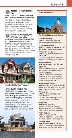
Martha’s Vineyard has something
for everyone, from proper Edgartown 2 Stonington Harbor
and the gingerbread architecture of MAP E5 • 7 Water St, Stonington, CT
Oak Bluffs to the sacred multicolored Granite lighthouse, now a museum.
clay cliffs revered by the Aquinnah 3 West Quoddy Head
Wampanoag tribe. MAP R2 • Quoddy Head State Park,
Lubec, ME
This iconic candy-striped light (1857)
marks the easternmost point of the US.
4 Marshall Point
MAP Q4 • Marshall Point Rd, Port
Clyde, ME
Offshore light connected by a walkway
to the keeper’s house and museum.
5 Pemaquid Point
MAP P4 • Off Rte 130, Bristol, ME
Built high on these dramatic ledges
in 1835, Pemaquid Point remains an
essential navigational aid.
6 Portsmouth Harbor
Oak Bluffs, Martha’s Vineyard MAP N6 • Off Rte 1B, New Castle, NH
Built in 1878, this is the latest of several
Burnt Island, ME
0 built on New Castle island since 1771.
MAP P4 • Balmy Days Cruises:
Pier 8, Boothbay Harbor; 207 633 2284; 7 Beavertail
MAP E5 • Beavertail State Park,
mid-Jul–Aug: 1:45pm Mon & Thu; Jamestown, RI
adm; www.balmydayscruises.com This is the third-oldest light on the
Cruise to this tiny island just eastern seaboard, built in 1783.
outside Boothbay Harbor for a 8 Highland
unique pro gram illuminating the MAP H3 • N Truro, MA
life of the lightkeeper and his Set atop a bluff at the Cape Cod
family, who lived here around 1950. National Seashore, this is the highest
light on the New England mainland.
9 Nobska Point
MAP G5 • Falmouth, MA
Sitting on the Shining Sea Bike Path,
Nobska is visible for 16 miles (26 km).
10 Great Point
MAP H5 • Nantucket Island, MA
Rebuilt in 1986 as a historic replica in
the Coskata-Coatue Wildlife Refuge.
050-051_Top_10_New_England.indd 51 21/12/2016 11:16