
Page 63 - (DK Eyewitness) Top 10 Travel Guide - New England
P. 63
Ways to See Foliage ❮❮ 61
Deerfield River Rafting,
8 TOP 10 COVERED BRIDGES
MA
MAP C2 • Zoar Outdoor: 800 532
7483; open Jun–Sep; adm; www.
zoaroutdoor.com
The Deerfield River has some of
the most exhilarating rapids and
most scenic gorges in New England.
Nothing compares to the rush of
bankside colors viewed from a raft
during foliage season.
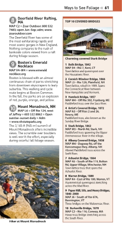
Charming covered Stark Bridge
Boston’s Emerald
9 1 Bulls Bridge, 1842
Necklace
MAP V4–W4 • www.emerald MAP B4 • Rte 7, Kent, CT
Town lattice and queenspost over
necklace.org the Housatonic River.
Boston is blessed with an almost 2 Cornish-Windsor Bridge, 1866
continuous chain of parks stretching MAP L5 • Rte 12A, Plainfield, NH
from downtown skyscrapers to leafy Town lattice, rebuilt in 1989. Spans
suburbia. This walking and cycle the Connecticut River between
route begins at Boston Common. New Hampshire and Vermont.
In the fall, the parks are an explosion 3 Hemlock Bridge, 1857
of red, purple, orange, and yellow. MAP M4 • Off Rte 302, Fryeburg, ME
Paddleford truss over the Saco River.
Mount Monadnock, NH
0 4 Artist’s Covered Bridge, 1872
MAP L6 • Off Rte 124, west
of Jaffrey • 603 532 8862 • Open MAP N3 • Off Rtes 2 and 26,
Newry, ME
sunrise–sunset daily • Adm Paddleford truss, also known as the
• www.nhstateparks.org Sunday River Bridge.
The 3,165-ft (965-m) summit of 5 Stark Bridge, 1862
Mount Monadnock offers incredible MAP M3 • North Rd, Stark, NH
views. The scramble over boulders Paddleford truss spanning the Upper
is well worth the effort, especially Ammonoosuc River in the village.
during colorful fall foliage season. 6 Albany Covered Bridge, 1858
MAP M4 • Dugway Rd, off the
Kancamagus Hwy, Albany, NH
Altered Paddleford truss across the
Swift River.
7 Ashuelot Bridge, 1864
MAP K6 • South of Rte 119, Bolton
Rd, Upper Village, Winchester, NH
Town lattice truss that spans the
Ashuelot River.
8 Warren Bridge, 1880
MAP K4 • East of Rte 100, Warren, VT
Asymmetrical queenspost stretching
across the Mad River.
9 Paper Mill, Silk, and Henry Bridges,
1840–2000
MAP J6 • South of Rte 67A,
Bennington, VT
Three bridges on the Waloomsac River.
10 Burkeville Bridge, 1870
MAP C2 • Rte 116, Conway, MA
Howe truss bridge stretching across
the South River.
Hiker at Mount Monadnock
060-061_Top_10_New_England.indd 61 21/12/2016 11:16