
Page 126 - (DK Eyewitness) Travel Guide - Southwest USA & National Parks
P. 126
124 LAS VEGAS LAS VEGAS 125
z Lake Mead about 150 million years ago.
National There are many well-maintained
Recreation Area trails across this wilderness,
including the Petroglyph
Road map A3. Tel (702) 293-8906; Canyon Trail, an easy half-mile
Alan Bible Visitor Center (702) 293- (0.8-km) loop, which takes in
8990. @ Las Vegas. Open 9am– several fine prehistoric Ancestral
4:30pm daily. Closed Jan 1, Puebloan rock carvings. Here,
Thanksgiving, Dec 25. & 7 limited. summer temperatures often
∑ nps.gov/lake reach 112°F (44°C). The best
time to visit is in spring or fall.
After the completion of the The nearby town of Overton
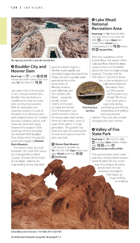
The imposing Hoover Dam across the Colorado River Hoover Dam, the waters of the lies along the Muddy River.
Colorado River filled the deep Ancestral Puebloan people (see
l Boulder City and gave this desert region a canyons that once tower ed pp30–31) settled here in around
Hoover Dam reliable water supply and above the river to create a huge 300 BC but left some 1,500 years
provided inexpensive electricity. reservoir. This lake, with its later, perhaps because of a long Rainbow Mountain in Red Rock Canyon National Conservation Area
Road map A3. * 12,500. ~ @ n Today, the dam supplies water 700 miles (1,130 km) of shore- drought. Archaeologists have
Hoover Dam Visitor Center: 9am–5pm and electricity to the line, is the centerpiece of unearthed hundreds of prehistoric the end of Nevada State Hwy National Conservation Area.
daily. Tel (702) 494-2517. & 7
three states of Lake Mead National artifacts in the area since the 157. This is the more southerly A gnarled escarpment rises out
Nevada, Arizona, Recreation Area, first digs began in the 1920s. of the two by-roads leading to of the desert, its gray limestone
Just eight miles (13 km) west and California, and a 2,344-sq-mile Overton’s Lost City Museum of Mount Charleston off Hwy 95; and red sandstone the geo-
of the colossal Hoover Dam, has created Lake (6070-sq-km) tract Archaeology, just outside the the other is Hwy 156, which logical residue of an ancient
Boulder City was built as a Mead – a popular of land. The focus town, has a large collection of runs to the Lee Canyon Ski ocean and the huge sand dunes
model community to house tourist center. is on water sports, pottery, beads, woven baskets, Area, catering to both skiers that succeeded it. Red Rock
dam construction workers. Visitors to the dam especially sailing, and delicate turquoise jewelry. and snowboarders. Canyon is easily explored on
With its neat yards and can take the Hoover Power boating on water skiing, and fishing. an enjoyable 13-mile (21-km)
suburban streets, it is one of Dam Powerplant Tour, Lake Mead Striped bass and rainbow E Lost City Museum scenic road that loops off Hwy
Nevada’s most attractive and which includes a trip to trout are popular of Archaeology v Red Rock Canyon 159. Beside the road are picnic
well-ordered towns. Its Christian the observation deck where catches. There are also several 721 S. Moapa Valley Blvd., Overton. Road map A3. Tel (702) 515-5350. @ spots and trailheads for a series
founders banned casinos, and there are panoramic views of campgrounds and marinas. Tel (702) 397-2193. Open 8:30am– Las Vegas. Open 8am–4:30pm daily. of short hikes that cover the
there are none here today. eight of the dam’s 17 huge 4:30pm daily. Closed Jan 1, Closed public hols. & 7 limited. area’s steep winding canyons.
Several of its original 1930s generators. The guided tour x Valley of Fire Thanksgiving, Dec 25 & 26. & 7 ∑ redrockcanyonlv.org The visitor center at the start
buildings remain, including leads through old construction of the road has informative
the restored 1933 Boulder tunnels and explains how the State Park c Mount From downtown Las Vegas, it is displays on the Canyon’s flora
Dam Hotel, which houses the dam was built. Road map A3. Tel (702) 397-2088. Charleston a short, 10-mile (16-km) drive and fauna. There are some 80
quaint yet engaging Hoover @ Las Vegas. Open 8:30am–4:30pm west to the low hills and steep to 100 bighorn sheep in the
Dam Museum. E Hoover Dam Museum daily. & 7 partial. Road map A3. Tel (702) 872-5486; gullies of the Red Rock Canyon conservation area.
The Hoover Dam was built 1305 Arizona St., Boulder City. ∑ parks.nv.gov/valley-of-fire (702) 515-5400 (Forest Service). @
between 1931 and 1935 across Tel (702) 294-1988. Open 10am–5pm Las Vegas. ∑ fs.usda.gov/htnf The Construction of the Hoover Dam
the Colorado River’s Black daily. Closed public hols. & 7 This spectacularly scenic state
Canyon, 30 miles (48 km) east ∑ bcmha.org park has a remote, desert location About 45 miles (72 km) northwest More than 1,400 miles (2,250 km) in length, the
of Las Vegas. Hailed as an some 60 miles (97 km) north- of Las Vegas, Mount Charleston Colorado River flows through seven states on its
engineering victory, the dam east of Las Vegas. Its name rises to 11,918 ft (3,633 m) out journey from the Rocky Mountains to the Gulf
derives from the red of Toiyabe National Forest, clad of California. A treacherous, unpredictable river,
it used to be a raging torrent in spring and a
sandstone formations with pine, mountain mahogany, trickle in the heat of summer. As a source of
that began as fir, and aspen. Also known as water it was therefore unreliable, and, in 1928, the
huge, shifting the Spring Mountain Recreation Hoover Dam seven states it served signed the Boulder Canyon
sand dunes Area, it offers refuge from the sign Project Act to define how
Las Vegas summer heat, with a much water each state
variety of hiking trails and picnic could siphon off. The agreement
areas. In the wintertime, skiing paved the way for the Hoover Dam,
and snowboarding are popular and its construction began in 1931.
(see p271). It was a mammoth task, and more
A range of hikes is available, than 5,000 men toiled day and night
including two demanding trails to build what was, at 726 ft (221 m),
that snake up to the summit: the world’s tallest dam. Named after
the 11-mile (18-km) North Loop Herbert Hoover, the 31st president
Trail and the 9-mile (14-km) of the US (1929–33) and an avid
South Loop Trail. Easier walks on supporter of the project, it contains
the forested slopes are also 17 hydroelectric generating units.
marked, including a one-hour
hike up Cathedral Rock. This The mammoth Hoover Dam
Extraordinary rock formations in the Valley of Fire State Park walk starts from a picnic area at
For hotels and restaurants see pp238–40 and pp251–4
124-125_EW_SW_USA.indd 124 28/11/17 12:40 PM 124-125_EW_SW_USA.indd 125 28/11/17 12:40 PM