
Page 8 - (DK Eyewitness) Travel Guide - Southwest USA & National Parks
P. 8
6 HOW T O USE THIS GUIDE HOW T O USE THIS GUIDE 7
LAS VEGAS 103
LAS VEGAS
HOW TO USE THIS GUIDE Las Vegas Rising like a mirage out of Nevada’s beautiful southern Introduction
desert, Las Vegas is a glittering wonderland that promises
fun to all its visitors. The city’s unique attraction is its
hotels with their fantastic architecture, re-creating such
This unique city has its own cities as New York and Venice. At the heart of these palaces 1The landscape, history, and
lie the casinos where the lure of million-dollar jackpots
draws almost 40 million visitors each year.
This travel guide helps you to get the most Colorado and Utah. Each chapter describes chapter, which is introduced Occupied by the Ancestral Puebloan the 1990s, numbers of ever more character of Las Vegas are
extravagant resorts have been built in
peoples until around 1150 AD, the Las
the city, including the impressive Bellagio,
Vegas area later became the home of
from your visit to the Southwest USA and the important sights, using maps, photographs, by a historical feature. The several Native American tribes, including Venetian, and Cosmopolitan, and this described here, showing how
expansion shows few signs of slowing.
the Paiute, until Mexican traders arrived
the city was developed and
For those who can tear themselves
in the early 19th century. Mormon
away from the city, the surrounding
pioneers built a fort here in 1855,
National Parks. Introducing the Southwest and illustrations. Recommended restaurants main sights are numbered establishing the beginnings of a country has much to offer. Lake Mead what it offers the visitor today.
and the stunning rock formations of the
settlement in the area, which gradually
Valley of Fire State Park provide a range
developed. Officially founded in 1905,
maps the region, and sets it in its historical and hotels are listed in Travelers’ Needs, and plotted on the City Map, the city of Las Vegas expanded in the of outdoor pleasures from horseback
1930s with the building of the Hoover
riding to watersports.
as are points of interest in
Dam across the Colorado River, some
In 2006, Las Vegas was the fastest
growing city in the US, but the
30 miles (45 km) away, and the
and cultural context. The region includes the as is advice on accommodations and food. the Greater Las Vegas area. legalization of gambling here in 1931. 104 population has since stabilized at just LAS VEGAS 105
The influx of construction workers with
under two million. Tourism and gaming
remain the most successful industries –
money to burn, and the electricity and LAS VEGAS
it has 20 of the 27 largest hotels in the
two states of New Mexico and Arizona, the The Survival Guide has tips on such issues The information for all the water provided by the dam, paved the Exploring Las Vegas NORTH 1ST ST E A ST WASHI NG TO N AV EN U E
world – but it is also known for its
way for the casino-based growth that
took place in the 1940s and 1950s. Since
wedding chapels and entertainment.
NO RTH MARYLAND PARKW A Y
city of Las Vegas, and sizeable chunks of as transportation and tipping. sights is easy to locate within Las Vegas has two centers – the wonderland of the Strip, 15 N LAS VEG AS BLVD NORTH 9TH ST E A ST BO NA NZ A R OAD 1 9
HA RR IS AV E NUE
and the older Downtown area, where the city began in
1905 (see pp100–101). The Downtown area focuses on
Fremont Street (see p122), while the Strip is a 4.5-mile-
the chapter as it follows the (7.2-km-) long section of Las Vegas Boulevard (Hwy 604) S TE WAR T AV E N U E EAST MESQUITE AVE
8TH ST
that runs southwest towards California. Strictly speaking,
Greyhound
LINDEN AVENUE T H S T R E E T
MARYLAND PARKWA Y
the part of the Strip that lies south of Sahara Avenue is in SOUTH G R A N D CENTRAL PARKWAY CASINO CENTER BOULEVARD 3RD ST FREMONT STREET 9TH
Bus Terminal
1ST ST
numerical order on the map. Clark County, while the city proper is centered around W BONNEVILLE AVE SOUTH MAIN STREET GARCES DOWNTOWN 14TH STREET The famous Forum at Caesars Palace
CARSON AVE
10TH ST
7TH ST
Downtown Vegas. Ringed by mountains, canyons, and
15
BRIDGER AVE
desert, the Las Vegas area also has a wealth of natural
beauty in a variety of national parks, some just a short 1ST ST CLARK AVENUE 1 5 T H ST RE E T Sights at a Glance
6TH ST
The city has its own Practical drive from the Strip (see pp124–25). C O M M E RC E S T R E E T COOLIDGE AVE 3R D S T 4TH ST AVENUE 16TH STREET LEWIS A VENU
EAST BONNEVILLE AVENUE
The Southwest Region 188 NE W MEXIC O INTRODUCING NE W MEXIC O 189 Information section, which W UTAH AVE SOUTH MAIN STREET CASINO CENTER BLVD SOUTH 3RD ST SWEENEY AVE NORMAN AVENUE 2 Luxor d Fremont Street Experience
9 Showcase Mall
E AS T
GASS AVE CH A RLES TO N B OUL EVAR D
1 Mandalay Bay
HUNTRIDGE
CIRCLE PARK
3 Excalibur
SOUTH 7TH ST
Museums and Galleries
4 New York New York
by Region Introducing New Mexico Getting Around offers useful advice on W E ST E RN AV E N UE W ST LOUIS W WYOMING AVE LAS VEGAS BOULEVARD SOUTH BEVERLY WAY SOUTH 5TH ST E A S T S T L O U I S
t The Auto Collections at
the LINQ
6 Tropicana
7 CityCenter
EAST
WEST CHICAGO
g Neon Museum
AVE
8 Cosmopolitan of Las Vegas
AVENUE
S 16TH ST
j The Las Vegas Natural
New Mexico’s scenic beauty, rich cultural heritage, and New Mexico has two major Interstate Highways, I-25 and SANTA FE AND Decorative stained-glass ceiling of Tropicana’s elegant casino INDUSTRIAL ROAD W CINCINNATI AVE AVE
W BALTIMORE
q Paris
I-40, which cross each other in Albuquerque. Interstate 25
History Museum
w Bellagio
The Southwest has been divided unique mix of Native American, Hispanic, and Anglo- cuts north into Colorado and south into Mexico. Interstate ALBUQUERQUE NORTHERN shopping, entertainment, SLS Station KAREN AVENUE KAREN
Replica Venice complete with canals and gondolas at The Venetian
EAST SAHARA AVENUE
SOUTH 17TH STREET
American people make it a fascinating place to visit. The
WINCHESTER
NEW MEXICO
40 cuts east to west, into Texas and Arizona respectively. To
I N D US TR IA L RO AD
Historic Park
r Flamingo Las Vegas
the south, Interstate 10 connects the city of Las Cruces with
forested peaks of the Rocky Mountains in the north offer
y The Venetian
Arizona. Albuquerque airport is New Mexico’s main hub for
AND SOUTHERN
Historic Towns and Cities
DEL MAR AVENUE
into five regions, each of which ski resorts in winter and cool retreats in the hot summers. both international and domestic flights. Greyhound buses NEW MEXICO and gambling. The dazzling sight of the Las Vegas Strip, illuminated at W ES TWO OD D RIVE
i Treasure Island
BEL A I R D R R K W AY
Northern New Mexico is also noted for its quality of light,
LAGUNA AVE
CIRCUS CIRCUS DR
run between Albuquerque and several major US cities.
VE GAS V A LL
with stark shadows and soft colors that have attracted
o Wynn Las Vegas & Encore
night by myriad shimmering neon lights
LAS VEGAS
PINEHURS T D RIVE
Areas of Natural Beauty
COUNTRY CLUB
p SLS Las Vegas
PALO R A A V E
STRIP
has its own chapter. Two of these generations of artists to the region, especially to the Chama Tierra Questa Costilla Raton Getting Around CAPELLA AVE 15 FASHIO N SHOW DR LAS VEGAS BOULEVARD SOUTH CONVENTION CENTER LV Convention EAST
creative centers of Santa Fe and Taos. Albuquerque is the
Recreation Area
s Stratosphere
x Valley of Fire State Park
DRIVE
state’s centrally located largest city, and, to the south,
JOE W. BR O W N DR I V E
c Mount Charleston
visitors can explore ancient Native ruins at Gila Cliff
LA CANADA STREET
EA ST DESERT INN ROAD
The Strip is a long road, and driving
Center Station
regions are further divided into Dwellings National Monument, as well as such natural Amarilla Abiquiu Ranchos Wheeler Peak Turkey Cimarron Springer Kiowa Clayton is the best way to get around. Major INDUSTRIAL ROAD SA N D S AVENUE COURSE WYNN GOLF PARADIS
4011m
SIERRA VISTA DRIVE
wonders as the gleaming dunes of White Sands National
LAS VEGAS
Taos Pueblo
hotels have free parking lots, as well
AL G ONQUIN DR IVE
NATIONAL
Taos
NORTH
as valet and shuttle bus services.
Monument and the cave systems of Carlsbad Caverns.
Lake
Central Las Vegas
CIRCLE
areas. All major towns and 0 kilometers 50 Abiquiu Espanola Chimayó Dixon de Taos Mountains Wagon Roy Grasslands The Deuce bus runs along the Strip, Harrah's & the EAST TW A IN AVENUE C A M B R I D G E S T R E E T
O TTAWA DRIVE
National
SOUTH
stopping at the major hotels, and
Ocate
continues to Downtown, while the
Major highway
Truchas Peak
Mound
0 miles 50 Jemez Springs Los Alamos Pojoaque 3993m Sang r e de Cr isto Ute Creek City Map monorail service operates between JAY SARNO WA Y Flamingo & Quad Station Flamingo Wash SWENSON STREET EAST VIKING ROAD
the MGM Grand and SLS Las Vegas.
Caesars Palace Station
attractions have been numbered Gallup Mount Taylor Jemez Pueblo Kewa Pueblo Santa Fe National Park Las Vegas Mountains Mosquero Nara Visa Taxis, Uber, and Lyft are also available. EAST FLAMIN GO ROAD Tropicana Wash
Pecos
PALO VERDE ST
EAST FLAMINGO ROAD
Historic
Bally's & Paris
Station
Conchas Lake
Canadian River
San Felipe
EAST ROCHELLE AVENUE
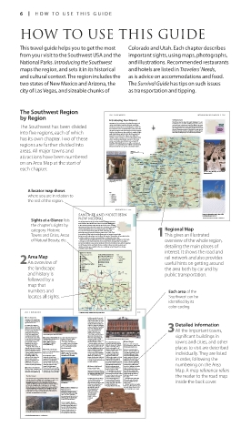
on an Area Map at the start of Zuni Mountains Milan Grants 3445m Laguna Albuquerque Alameda Pueblo Moriarty Anton Chico Pecos River Conchas Dam Tucumcari Ute Reservoir 2For easy reference, Key The Strip see pp106–109 LAS VEGAS BOULEVARD
Thoreau
Rio Rancho
Zuni
Bernalillo
EAST UNIVERSITY AVE
Wildlife
sights are numbered
Las Vegas Dunes
San Rafael
Recreation Lands
Isleta Pueblo
each chapter. Acoma Pueblo Rio Puerco Los Lunas Manzano Vaughn Santa Rosa Grady RUE DE MONTE SOUT H L AMA R C T E N AP LE S RO A D LORILYN AVE GABRIEL DRIVE Las Vegas LAS North Winchester Sunrise 147 147
Manor
Mountains
CARLO
VEGAS
Lake
Willard
ELIZABETH AVE
Station
Ladron Peak Belen Sumner Ancestral Puebloan cliff dwellings at Bandelier National and located on a map. 0 kilometers 1 MGM Grand EAST TROPICANA AVENUE
Rio Salado 2797m Manzano Fort Sumner Melrose Clovis Blue Mead
Madre Mount Peak Mountainair Monument (see p204) LULU AVE Mountain
Quemado 3078m 0 miles 1 Springs Diamond Boulder Beach
2913m Yeso Texico SOUTH McCarran WILBUR STREET SPENCER STREET Enterprise 515 ARIZONA
RENO AVENUE
EAST RENO AVENUE
Airport
Gallo Magdalena Los Pinos Mountains Corona Portales STRIP International RENT A CAR ROAD PARADISE ROAD P ARADISE 160 0 miles 10 Sloan 93
Mountains Mountain Alegres NEW MEXICO 15 TAMARUS STREET 15 95 Co lo r ado
Adobe in Albuquerque’s Old Town 3118m South Baldy Socorro Lincoln Elida EAST HACIENDA AVENUE WESTMINSTER AVE EAST HACIENDA AVENUE 0 km 10
S W E N S O N S T R E ET
(see pp214–15) Tularosa Mountains Plains of San Agustin Mount 3287m San Antonio National For hotels and restaurants see pp238–40 and pp251–4
Reserve Withington F or est Pecos River For keys to symbols see back flap
3083m
Eagle Peak Carrizozo
Whitewater 2983m Rio Grande Capitan Capitan Peak
3073m
Baldy
Gila Cliff
3321m Dwellings Black Range Blanca Sierra Lincoln Roswell
A locator map shows Mountains Monument Truth or Consequences Jornada del Muerto Tularosa 3649m Peak Ruidoso Sacramento Dexter Tatum
Elephant Butte
National
Reservoir
Mogollon
where you are in relation to Key Highway Silver City Central Hillsboro Mimbres San Andres Mountains Monument T u l a r o s a Va l l e y gordo Cloudcroft Mountains Artesia Hagerman Lovington
White Alamo-
Sands
Mayhill
National
Major road
Hobbs
the rest of the region. Minor road Lordsburg Hurley Cookes Peak Hatch Guadalupe Carlsbad Lake McMillan Eunice
Mountains
State border
Summit
2563m
Peak
Wind
Pyramid Deming Las Cruces Mesilla Organ Orogrande Mountains Carlsbad Loving Malaga
Caverns
National
2704m
Mountains Mountain
Mountains
Animas Florida Mesa La Anthony 2219m Monument Jal 196 NE W MEXIC O SANT A FE 197
NE W MEXIC O 195 Animas Valley Playas Lake Columbus Canutillo El Paso Street-by-Street Map
SANTA FE AND NORTHERN Animas Peak Big Hatchet Peak Soaptree yucca plant growing among the dunes at White 3This provides a bird’s-eye 1 Street-by-Street: Central Santa Fe Plaza VISITORS’ CHECKLIST
2597m
Practical Information
2550m
The oldest state capital in North America, Santa Fe was founded
Sands National Monument (see p227)
Road map E3. * 84,000. n Plaza
by the Spanish conquistador Don Pedro de Peralta, who created
Sights at a Glance lists NEW MEXICO For keys to symbols see back flap For hotels and restaurants see pp241–2 and pp258–9 view of the heart of a a colony here in 1610 (see p43). This colony was abandoned in Galeria, 66 E. San Francisco St. (505)
955-6215. _ Spanish Market
(Jul); Indian Market (Aug); Fiestas
1680 following the Pueblo Revolt, but settlers recaptured it in
The beauty of the landscape and the wealth of cultural attractions
the chapter’s sights by make northern New Mexico one of the most popular destinations sightseeing area. 1692 (see p44). When Mexico gained independence in 1821, de Santa Fe (Sep). ∑ santafe.org
Transport
Santa Fe was opened up to the wider world, and traders and
in the Southwest. Visitors drive through the forests of the San Juan
Mountains and the peaks of the Sangre de Cristo Range, part of the settlers from the US arrived via the Santa Fe Trail (see p29). ~ Santa Fe Municipal Airport,
10 miles (16 km) SW. of Santa Fe.
category: Historic southern Rocky Mountains, then through picturesque villages to Regional Map The central plaza has been the heart of Santa Fe since its . New Mexico Museum of Art . Palace of the Governors £ Lamy, 18 miles (29 km) S. of
This museum focuses on the
founding, and there is no better place to begin exploring the
city. Rail Runner: Santa Fe Depot.
paintings and sculpture of
meet the Rio Grande valley. It was this fertile landscape that
city. Today, it houses a Native American market under the portal
(866) 795-7245. ∑ riometro.org
Towns and Cities, Areas probably attracted Ancestral Puebloan people in the 1100s. Their 1This gives an illustrated of the Palace of the Governors, and the square is lined with Southwestern artists. This single-story adobe building dates back to the early Mu
17th century. Now part of the New Mexico History Museum,
descendents still live today in pueblo villages, and are famous for producing
the palace houses displays on the city’s history.
shops, cafés, and galleries.
distinctive crafts and pottery. Taos Pueblo is the largest of the pueblos, its fame due both to
its adobe architecture and its ceremonial dances performed on feast days. Contemporary
of Natural Beauty, etc. Southward lies the beautiful city of Santa Fe. Founded by Spanish colonists in 1610, Santa overview of the whole region, Native Arts
Fe is now one of the most visited cities in the United States, renowned for its art galleries
and adobe buildings. Today, tourism dominates this historic trading center, with its appealing L I N C O L N
mix of Hispanic, Native, and Anglo-American cultures. Many specialty vacations and
outdoor activities are available in the area, including archaeological tours, skiing, detailing the main places of
and white-water rafting. S H E R I D A N
interest. It shows the road and A V E N U E C A T H E D R A L P L A C E
Sights at a Glance
Area Map Historic Towns and Cities Parks and National Monuments Key Interstate rail network and also provides The Plaza P A L A C E E . S A N F R A N C I S C O S T R E E T
1 Santa Fe
4 Bandelier National Monument
5 Pecos National Historical Park
2 Los Alamos
The obelisk at the center of this main square
Major highway
2An overview of 3 Jemez Springs Areas of Natural Beauty Highway useful hints on getting around commemorates the Anglo defeat of New P L A Z A
6 Las Vegas
Mexico’s Native peoples. The Plaza is dominated
7 Northern Pueblo Tour
q Taos
Railroad
t Enchanted Circle Tour
by the Palace of the Governors and lined
Historic Villages and Pueblos
with old colonial buildings.
Ski Areas
the landscape 8 Chimayó r Taos Ski Valley the area both by car and by O L D S A N T A F E T R A I L
9 Abiquiu
0 Chama
w Ranchos de Taos
and history is e Taos Pueblo 0 km 0 miles 40 40 public transportation. Stars indicate the sights B U R R O A L L E Y W . S A N F R A N C I S C O S T R E E T E . W A T E R S T R E E T
followed by a Antonito that no visitor should miss. D O N G A S P A R A V E N U E
map that Gobernador Dulce 64 Tierra 84 64 Tres 258 Questa Cimarron Raton 25 64 Des Moines G A L I S T E O S T R E E T La Fonda
Navajo
Hotel
Lake
numbers and Counselor Amarilla 84 Piedras Taos Springer Abbott Clayton Stead Each area of the A suggested route for a W A T E R S T R E E T Loretto Chapel
56
locates all sights. Cuba 550 Coyote Española Truchas La Cueva Mora Cana dian Roy Southwest can be walk is shown in red. 0 meters 100 Built in Gothic style by
French architects in
the 1870s, the Loretto
Santa 25 419 0 yards 100 Chapel was modeled
Jemez Fe identified by its on Sainte-Chapelle in
Pueblo Rio Grande Trujillo Conchas 39 54 Original Trading Post Paris. The building St. Francis Cathedral
Pecos
Los Montoyas Lake Key This historic trading post and elegant spiral This colorful, carved wooden statue of
104 Logan sells Hispanic art, staircase inside were the Virgin stands in a chapel belonging
25 258 84 color coding. Suggested route antiques, and Native commissioned for the to the original 17th-century church on
40 Albuquerque Moriarty 40 40 Tucumcari American crafts. Sisters of Loretto. which the cathedral was built in 1869.
Santa Rosa 209 For hotels and restaurants see pp241–2 and pp258–60
204 NE W MEXIC O Chili ristra decorating a traditional adobe home, Ranchos de Taos NOR THERN NE W MEXIC O 205 92 ARIZ ONA TUCSON 93
2 Los Alamos Puebloan peoples for around San Xavier del Bac Mission VISITORS’ CHECKLIST
500 years from the 12th to the
Road map E3. * 12,000. n 109 16th centuries when successive
Central Park Square (505) 662-8105. communities grew corn and San Xavier del Bac is the oldest and best-preserved mission Practical Information
∑ visit.losalamos.com squash, as well as hunting. The Detailed Information church in the Southwest. An imposing landmark as it rises out Road map: C5. 1950 W. San Xavier
Rd., 10 miles (16 km) south of
The town of Los Alamos is earliest occupants are thought of the stark, flat landscape of the surrounding Tohono Tucson on I-19. Tel (520) 294-
O’odham reservation, its white walls dazzle in the desert sun.
famous as the location of the to have carved the soft volcanic .Main Altar 2624. Open 7am–5pm daily. For all top sights, a Visitors’
Manhattan Project (see p190), rock of the towering cliffs to A mission was first established here by the Jesuit priest Father The spectacular gold and red 7 - =
the US Government’s top-secret make cave dwellings; later 3All the important towns, Eusebio Kino in 1700 (see p44). The complex seen today was retablo mayor is decorated in ∑ sanxaviermission.org
research program for the people built houses and completed in 1797 by Franciscan missionaries. Mexican Baroque style with Checklist provides all the
development of the atomic pueblos from rock debris. Built of adobe brick, the mission is considered to be the elaborate columns. More than
bomb during World War II. Façade of Bradbury Science Museum in Los Alamos One of the most fascinating 50 statues were carved in
Government scientists took sights here is the ruin of the significant buildings in finest example of Spanish Colonial architecture in the US The Hill of the Cross, to the east of the Mexico then brought to San practical information you
mission, offers fine views
(see p26). The church also incorporates other styles, including
over this remote site in 1943. E Los Alamos Historical Museum is open only on feast days and 400-room Tyuonyi village. The and painted them with
Xavier where artists gilded
In 1945 the first atomic bomb 1050 Bathtub Row. Tel (505) 662-6272. festivals; call Jemez Springs settlement is laid out with The façade of the Plaza Hotel in the main square of Las Vegas several Baroque flourishes. In the 1990s its interior was brightly colore
was detonated at the Trinity Open 10am–4pm Mon–Fri visitor center for dates. semicircular lines of houses on towns and cities, and other extensively renovated, and five retablos (altarpieces) have
test site in the southern (9:30am–4:30pm in summer), The region is famous for its the floor of Frijoles Canyon. Pecos Puebloans acted as a 6 Las Vegas been restored to their original glory. need to plan your visit.
New Mexico desert near 11am–4pm Sat, 1–4pm Sun. hot springs. Spence Hot Springs, From the visitor center, also in conduit for goods like buffalo Road map E3. * 13,500. @ £ Altar Dome
Alamogordo (see p228). Closed public hols. 7 7 miles (11 km) north of town, the canyon, the Main Loop Trail skins and meat, and Puebloan n 1224 Railroad Ave. (505) 425-8631. .Façade of the church The dome and high transepts
Today, the town is home to has several outdoor hot pools leads past Tyuonyi to some of products including pottery, ∑ lasvegasnewmexico.com places to visit are described The ornate Baroque façade is decorated are filled with painted wooden
scientists from the Los Alamos linked by waterfalls. the cave dwellings and the Long textiles, and turquoise. The with the carved figures of saints (although statuary and covered with
murals depicting scenes
National Laboratory, a leading 3 Jemez Springs House, multistoried dwellings village is thought to have been Not to be confused with its some are much eroded) including a from the Gospels.
defense facility. The Bradbury Road map E3. * 450. n Highway 4. T Jemez State Monument built into an 800-ft (240-m) among the largest in the Nevada cousin (see pp98–135), headless St. Cecilia and an unidentifiable
Science Museum showcases its ∑ jemezsprings.org Off Hwy 4. Tel (575) 829-3530. Open stretch of the cliff. Petroglyphs Southwest. It stood up to Las Vegas, New Mexico has its individually. They are listed St. Francis, now a simple sand cone.
work, with security and 8:30am–5pm Wed–Sun. Closed Mon, can be spotted above the holes 5 stories high, with nearly own high-rolling past. Vegas
technology exhibits, and The small town of Jemez Tue, public hols. & 7 partial. which once held the roof 700 rooms housing over means “meadows” in Spanish,
replicas of Little Boy and Fat Springs lies in San Diego beams. Another short trail leads 2,000 people, a quarter of them and the town’s old Plaza was
Man, the atomic bombs Canyon, by the Jemez River, on to the Alcove House, perched warriors. When the Spanish established along the lush in order, following the
dropped on Hiroshima and land once occupied by the 150 ft (45 m) up in the rocks and arrived in the early 1540s, it riverfront by Spanish settlers Top Sights in the
Nagasaki in 1945. The Los Giusewa Pueblo. Its ruins and reached by ladders. was a strong regional power. But in 1835. A lucrative trade stop
Alamos Historical Museum those of a 17th-century mission by 1821 Comanche raids, disease, on the Santa Fe Trail, Las Vegas numbering on the Area
covers local geology and history. church are now part of the and migration had taken their soon became a wild frontier 4Southwest
Jemez State Monument. 5 Pecos National toll; the pueblo was almost town. Doc Holliday, who briefly
E Bradbury Science Museum Remnants of the mission walls Historical Park deserted, and the inhabitants owned a saloon here, was
15th & Central Ave. Tel (505) 667-4444. and a reconstruction of its huge moved to Jemez Pueblo. among its legendary characters Map. A map reference refers
Open 10am–5pm Tue–Sat, 1–5pm main gates are here. A few miles Road map E3. Hwy 63. Tel (505) 757- The pueblo site can be seen (see p59). The coming of the These are given two or more
Sun & Mon. Closed public hols. 7 south on Hwy 4, Jemez Pueblo 7241. Open Jun–Aug: 8am–6pm daily; on a 1.25-mile (2-km) trail that railroad in 1879 brought even
Sep–May: 8am–4:30pm daily. Closed winds past them and the ruined greater pros perity, and new
Dec 25. & 7 ∑ nps.gov/peco
The Rio Grande remains of two Spanish mission building took place around the reader to the road map full pages. Historic buildings
churches. There are also two
the station.
One of America’s great rivers, the Rio Grande evokes romantic images Located across Hwy 63, about reconstructed kivas (sacred Grand Victorian architecture Stonework detail
of frontier legends, from Billy the Kid to John Wayne. Its mythic status 25 miles (40 km) southeast of ceremonial sites). The visitor still prevails and self-guided The identity of the carved statues to
grew up from movies and TV westerns, but its historical and Mission church of San Jose at Jemez Santa Fe, Pecos National center has exhibits of historic tours are available from the inside the back cover. the left of the entrance has changed.
geographical importance is no less fascinating. From its source in State Monument Historical Park includes the ruins artifacts and crafts, and a video visitor center. Long thought to be St. Catherine of are dissected to reveal their
Colorado, the fifth-longest river in the United States flows southeast of the once-influential Pecos covering 1,000 years of Outdoor activities are pop ular Siena and St. Barbara, they have now
for 1,885 miles (3,000 km) to the Gulf of Mexico. It crosses New Pueblo. Situated in a pass Puebloan history in the area. in the area, with golf resorts and been identified as St. Agatha of
Mexico, then forms the entire boundary between Texas and Mexico. 4 Bandelier National through the Sangre de the water sports of Storrie Lake Catania and St. Agnes of Rome.
Used for irrigation since ancient times by the pueblos, in the 16th Cristo Mountains, the just a few miles out of town. interiors; interesting districts
century, Spanish settlers established towns and villages along the Monument pueblo dominated KEY
length of the river. Today, crops including cotton, citrus fruits, and Road map E3. Off Hwy 4. Tel (505) trade routes between
vegetables are grown along its fertile banks.
672-3861. Open sunrise–sunset daily; the Plains Indians 1 The mortuary chapel contains a are given street-by-street
visitor center: 9am–4:30pm daily and the Pueblo statue of the Virgin Mary, surrounded
(8am–6pm Memorial Day to Labor Day). peoples between by candles.
Closed Jan 1, Dec 25. & 7 partial. 1450 and 2 The bell tower’s elegant, white
No pets. ∑ nps.gov/band 1550. dome reflects the Moorish styles that Painted ceiling maps, and national parks
Set in the rugged cliffs and are incorporated into San Xavier’s On entering the church,
Spanish Colonial architecture.
visitors are struck by the
canyons of the Pajarito Plateau, 3 The patio is closed to the public dome’s ceiling with
Bandelier National Monument but can be seen from the museum. its glorious paintings of and forests have maps
has over 3,000 archaeological 4 The museum includes a religious figures. Vivid Chapel of Our Lady
sites that are the remains of an sheepskin psalter and photographs pigments of vermilion The shop This statue of the Virgin is one of the
The dramatic Rio Grande Gorge carved by the river, south of Taos Ancestral Pueblo culture. The of other historic missions on the and blue were used to entrance Church’s three sculptures of Mary. showing facilities and trails.
site is thought to have been
Here she is shown as La Dolorosa or
Tohono O’odham Reservation.
contrast with the stark
occupied by ancestors of the One of the ruined Spanish mission churches in Pecos National Historical Park white stone background. Sorrowing Mother.
For hotels and restaurants see pp236–43 and pp248–61 For hotels and restaurants see pp236–43 and pp248–61
006-007_EW_SW_USA.indd 6 04/12/17 12:10 pm 006-007_EW_SW_USA.indd 7 04/12/17 12:10 pm