
Page 236 - (DK Eyewitness) Travel Guide 2017 - Alaska
P. 236
234 ALASK A AREA B Y AREA
Exploring Beyond Nome Gold Rush village of Council, but
the village is best accessed with
Located on the Seward Peninsula, Nome may be remote, the help of local boat owners.
but it is the hub of an extensive wilderness road sys tem.
Most visitors rent a vehicle or join a tour to explore the } Kougarok Road
89 miles (143 km) to Kougarok Bridge.
area’s wild hinterlands. The drive east along the coast to Pilgrim Hot Springs Turn-off at Mile
Council includes fine bird-watching and the remains of a 62. Tel 443-5252.
failed railroad, while the Kougarok Road accesses remote Also known as the Taylor Road,
hot springs. The Teller Road leads through spectacular the wonderfully scenic Kougarok
scenery to the end-of-the-world vil lage of Teller on the Road passes through the
windswept coast of the Bering Sea. Kigluaik Mountains, paral leling
the Wild Goose Pipeline, which
was built in 1909 to transport
Sights at a Glance Key water to Nome but never
1 Council Road Minor road used. North of the mountains,
2 Kougarok Road Trail a graveled spur road leads to
3 Teller Road an oasis of cottonwood trees
at Pilgrim Hot Springs. The
site has a simple wooden hot
•
Igloo tank, which visitors can use after
Kougarok
Brevig Mission Bridge getting a permit from the
• Bunker Hill Bendeleben Mountains
• Teller Nome Visitor Center. Beyond the
Port •
Clarence Imuruk springs, the road passes through
Basin • Pilgrim Hot Springs wetlands and tundra to its end
at Kougarok Bridge. From here,
Kigluaik Mountains
Bering Council a rough track leads to Taylor.
Sea TELLER ROAD Salmon • Niukluk
Singigyak • KOUGAROK RD Lake COUNCIL RD } Teller Road
Skookum
66 miles (110 km) to Teller.
Mountain
Last Train
0 km 30 to Nowhere • Solomon Pass • White Leaving Nome, this beautiful,
• Golovin lonely road follows clearwater
0 miles 30 Nome Safety Sound Lagoon
streams, grasslands, and steep
climbs on its way to Teller.
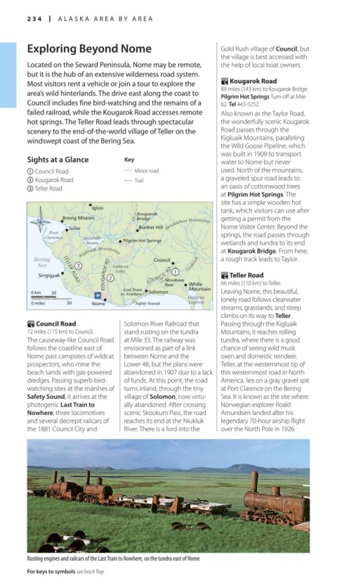
} Council Road Solomon River Railroad that Passing through the Kigluaik
72 miles (115 km) to Council. stand rusting on the tundra Mountains, it reaches rolling
The causeway-like Council Road at Mile 33. The railway was tundra, where there is a good
follows the coastline east of envisioned as part of a link chance of seeing wild musk
Nome past campsites of wild cat between Nome and the oxen and domestic reindeer.
prospectors, who mine the Lower 48, but the plans were Teller, at the western most tip of
beach sands with gas-powered abandoned in 1907 due to a lack this westernmost road in North
dredges. Passing superb bird- of funds. At this point, the road America, lies on a gray gravel spit
watching sites at the marshes of turns inland, through the tiny at Port Clarence on the Bering
Safety Sound, it arrives at the vil lage of Solomon, now virtu- Sea. It is known as the site where
photogenic Last Train to ally abandoned. After crossing Norwegian explorer Roald
Nowhere, three locomotives scenic Skookum Pass, the road Amundsen landed after his
and several decrepit railcars of reaches its end at the Niukluk legendary 70-hour airship flight
the 1881 Council City and River. There is a ford into the over the North Pole in 1926.
Rusting engines and railcars of the Last Train to Nowhere, on the tundra east of Nome
For keys to symbols see back flap
234-235_EW_Alaska.indd 234 02/05/17 2:32 pm