
Page 9 - (DK Eyewitness) Travel Guide - Belgium & Luxembourg
P. 9
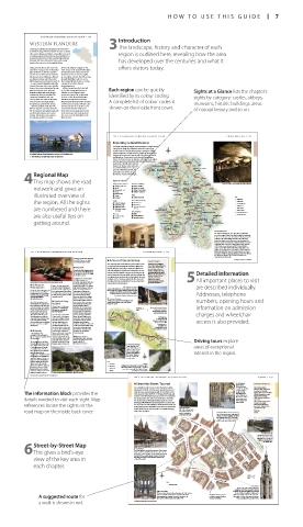
HOW T O USE THIS GUIDE 7
BEL GIUM AND L UXEMBOURG REGION B Y REGION 109 Introduction
WESTERN FLANDERS
Charming, fascinating and glorying in the treasures of 3The landscape, history and charac ter of each
its historic heritage, Western Flanders is home to vibrant
cities such as Bruges and Ghent, and smaller towns such region is outlined here, revealing how the area
as Oudenaarde, Kortrijk and Veurne. Around them lies a
tranquil rural landscape of flat or gently hilly farmland,
threaded with rivers and canals. To the north, sandy has developed over the centuries and what it
beaches face out on to the bracing North Sea.
Owing to its location at the crossroads battered by religious struggles in the offers visitors today.
of northern Europe, and to its boundary 16th century as the Spanish Netherlands
with the North Sea, Western Flanders disintegrated, then fought over by the
has often been thrust into the forefront Austrians, the French and the English
of historical events. Although a Flemish- in succeeding centuries. The 20th century
speaking land, it was ruled during the brought World War I, which scored a
Middle Ages by French kings (see pp41–2) line through Western Flanders, creating
– a cause of much frustration and strife. a wasteland on either side and
Despite this, many of the cities, notably demolishing Ieper.
Bruges, Ghent, Ieper, Kortrijk and Veurne, All this changed over the latter half
were rich from the cloth trade and of the 20th century with the rise of Each region can be quickly Sights at a Glance lists the chapter’s
industrious with crafts meticulously Flanders as one of Europe’s most
regulated by their proud guilds. The prosperous regions. The architectural identified by its colour coding.
Golden Age followed in the 15th treasures of the old medieval towns, sights by cate gory: castles, abbeys,
century, when the dukes of Burgundy sidelined and ignored for centuries,
took possession and made Bruges but preserved untouched, were restored, A complete list of colour codes is
the glittering capital of their empire. and the historic heritage of Flanders has museums, historic buildings, areas
However, between 1500 and 1945, now become one of its greatest assets.
Western Flanders was in the doldrums. Furthermore, Western Flanders has shown on the inside front cover. of natural beauty and so on.
The economy became largely rural, with done much to encourage visitors, be it
small cottage industries such as lace- in the great cities, the countryside, on
making. The land became a pawn in the coast, or on the battlefields of the
the big-game politics of Europe, Western Front.
198 BEL GIUM AND L UXEMBOURG REGION B Y REGION CENTR AL W ALL ONIA 199
Exploring Central Wallonia
The fertile, undulating lowlands of Brabant Wallon are the farmland
setting for the battle site of Waterloo and for the university at
Louvain-la-Neuve. The River Meuse forms a centrepiece, linking
The traditional Flemish way of shrimp fishing from horse-drawn carts, at the Oostduinkerke beach Dinant and Namur. It is flanked by the Citadelle of Namur and the
and Maredsous. Couvin nestles in the forested Fagne region,
Houses with Baroque-style gables along the banks of the Graslei, Ghent châteaux of Annevoie and Freÿr, as well as the abbeys of Floreffe
close to the famous Grottes de Neptune at Petigny. Steam engines Brussels
puff their way through the Viroin valley between Mariembourg FONDATION Wavre (Geldenaken)
Jodoigne
and Treignes. The hills of the Ardennes FOLON Lasne (Waver) Liège
begin to rise further to the south and WATERLOO WALIBI Jaųche
east, where the River Lesse carves a Braine- LOUVAIN-LA- FOLX-LES-CAVES
path out of the limestone hills. The le-Château Braine l’Alleud Ottignies NEUVE Ramillies
(Eigenbrakel)
BRAB ANT WALLO N
spectacular caves of Han-sur-Lesse
Regional Map lie in the far southeast of the region. NIVELLES ABBAYE DE Méhalgne
Éghezée
4This map shows the road Sights at a Glance (NIJVEL) Charleroi VILLERS Gembloux Beuzet Bierwart
CHÂTEAU
Villages, Towns and Cities Churches and Abbeys CORROY-LE- Mielmont Meuse Andenne Visitors descend the cavernous depths of the grotto at Rochefort
network and gives an 1 Waterloo pp200–201 6 Abbaye de Villers Charleroi Sambreville Sambre ABBAYE Wépion NAMUR Haillot
Jemeppe
0 Abbaye de Floreffe
(NAMEN)
7 Nivelles
r Abbaye de Maredsous
8 Namur pp206–207
DE FLOREFFE
illustrated overview of e Dinant i Basilique St-Materne Fosses-la-Ville Profondeville RIVER MEUSE Samson N AM UR Havelange
Gesves
o Mariembourg
Parks
JARDINS
p Couvin
f Rochefort q Jardins d’Annevoie D’ANNEVOIE Assesse Key Motorway
the region. All the sights Castles Areas of Natural Beauty MAREDSOUS Bouvignes BRASSERIE DU BOCQ Baillonville Major road
Spontin
Bocq
ABBAYE DE
9 Corroy-le-Château
5 Folx-les-Caves
Secondary road
t River Meuse
y Château de Freÿr
Ciney
are numbered and there u Château de Vêves d Domaine des Grottes SAINT-MATERNE Silenrieux Morialmé Florennes Falaën Anseremme Vêves DINANT Celles CHÂTEAU DE VÊVES Haversin Minor road
Molignée
Valley
Main railway
de Han
s Château de Lavaux
BASILIQUE
Minor railway
Ste-Anne
Sites of Interest
International border
are also useful tips on Museums 3 Walibi I’Eau d’Heure Philippeville CHÂTEAU Waulsort Houyet Lesse ROCHEFORT Provincial border
DE FREŸR
Lacs de
4 Louvain-la-Neuve
2 Fondation Folon
a Treignes w Brasserie du Bocq Cerfontaine Hermeton Agimont CHÂTEAU DE
getting around. MARIEMBOURG TREIGNES Meuse LAVAUX-SAINTE-ANNE DOMAINE DES
Fagne
GROTTES DE HAN
Beauraing
Viroin
Eau Blanche Nismes Bois de Luxembourg City
COUVIN Petigny (Viroinval) Savry Famenne
Eau Noire Forêt de Houille Getting Around
Nismes
Brûly-de-Pesche Gedinne The main motorway, the E411 (A4), slices southwards
across the region, connecting Brussels with Luxembourg.
Houdremont Biėvre It intersects the main east–west link, E42 (A15), just north
of Namur. The SNCB railway network covers all major
towns, but fewer areas in the more remote regions, for
instance, in the area between Couvin and Dinant. A more
comprehensive coverage is offered by the bus network
of TEC Namur-Luxembourg and TEC Brabant Wallon.
Cruises on the River Meuse link Namur and Dinant. For
0 kilometres 10 walkers and cyclists, there is the RAVeL 2 all the way from
228 BEL GIUM AND L UXEMBOURG REGION B Y REGION EASTERN W ALL ONIA 229 Mariembourg in the south to Hoegaarden, near Leuven
0 miles 10 in Flanders. It follows disused railways and the River Meuse,
via Dinant and Namur. The GR paths for walkers are
The resplendent interior of De Groesbeeck de Croix museum at Namur concentrated in the south.
in after the castle was sacked by
For hotels and restaurants see p269 and pp289–90
Louis XIV of France in 1689; it u A Tour of the Amblève For keys to symbols see back flap
was dismantled after 1804. Tips for Drivers
One of the key rivers of the Ardennes, the Amblève carves Starting point: Comblain-au-
a picturesque path through hills and forests. Walks here Pont – exit to Sprimont from A26.
y Stavelot lead off along the river’s edge or to the woodland water- Tour length: 55 km (35 miles).
Driving conditions: The roads
10 km (6 miles) SW of Malmedy. Road falls of the tributaries. Quarries and a railway line are seen Duration: Allow half a day.
Map E3. * 6,670. £ @ n Abbaye early on, but after Aywaille, a busy centre for summer visi- are narrow and busy, but good.
de Stavelot, Place St Remacle 32; (080) tors, the landscape becomes wilder and the road hugs the Where to eat: Rest aurants can be Detailed information
862706. ∑ stavelot.be river, giving access to picnic sites on the banks. It then rises found at Comblain-au-Pont,
Founded in the 7th century as to villages such as Stoumont, which offer fine views over Aywaille and Stoumont.
Visitors’ information:
Racing exhibits at the Musée du Circuit de Spa-Francorchamps, Stavelot an abbey, Stavelot is an the valley. The famous waterfalls at Coo are an impressive Remouchamps: (04) 3843544, 5All important places to visit
attractive town whose old centre
note on which to end the drive.
∑ ourthe-ambleve.be
e Château de Fagnes. Its main attraction is is a cluster of little streets and
squares lined with 17th-century
Reinhardstein the 18th-century Cathédrale half-timbered houses. Here, the 1 Comblain-au-Pont are described individually.
Sts-Pierre-Paul-et-Quirinn, set Église St-Sébastien houses a South of the Amblève’s scenic confluence with the
Chemin du Cheneux 50, Ovitat; 17 km River Ourthe are strange sculptures formed by hard
(15 miles) SE of Spa. Road Map F3. in the main square, Place Albert masterpiece of Mosan art – dolomitic rock that has resisted erosion. Equally
Tel (080) 446868. Closed Mon, Wed, 1er. Malmedy is most famous for the 13th-century reli quary of sculptural stalactites can be seen in Comblain’s Addresses, telephone
Fri. & 8 11:15am & 2:30pm daily, its four-day pre-Lenten carnival, St Remaclus, founder of the Découvertes Mystères limestone caves.
2:30pm (public holidays). Cwarmê (see p39). abbey at Stavelot. The striking
∑ reinhardstein.net deep-red Abbaye de Stavelot 2 Château d’Amblève
t Castle of Burg- dates from the 18th century. It A walk across the river from Aywaille ends in numbers, opening hours and
The 14th-century fortress of now contains three museums. a ruined cas tle linked to the steed Bayard
Reinhardstein was built by the Reuland The Musée du Circuit de Spa- legend (see p143).
lords of Waimes and owned by 38 km (24 miles) SE of Malmedy. Francorchamps, with its
their descendants, the German Road Map F3. Tel (080) 329131. collection of cars, motorcycles 0 kilometres 3 3 Sougné-Remouchamps information on admission
Metternich family.The château @ Open 9am–5pm daily. 0 and memorabilia, documents 0 miles 3 Visits to the Grottes de
was attacked by the French ∑ burg-reuland.be the history (from 1896) of the Sprimont Remouchamps include a
Revolutionary Army in 1795, Grand Prix motor-racing track Ourthe Fraiture subterranean boat trip.
after which it fell into ruin. In Located in the south of the at Francorchamps, which lies charges and wheelchair
1969, historian and collector Cantons de l’Est, the pretty about 10 km (6 miles) to the 4 Ninglinspo
Jean Overloop re built it. Today, slate-roofed vil lage of Burg- north. There is also the Musée A signposted walk
tours take visitors through Reuland is home to one of de la Principauté de Stavelot- Comblain-au- Aywaille through woodland leads
stone-walled rooms containing the most impressive sets Malmèdy and the Musée Pont along a stream called access is also provided.
furniture, tapestries, sculpture of castle ruins in Belgium. Guillaume Apollinaire, dedicated Ninglinspo to La
and armour. The Romans built a fort on to this French poet (1880–1918) Chaudière (The
this site and the Franks made who wrote eloquently about Cauldron), where the
r Malmedy it a royal castle: Charlemagne the Ardennes. Stavelot is also Amblève stream falls into a basin.
known for its carni val, the
is said to have stayed in it.
13 km (8 miles) SE of Spa. However, the ruins seen today Laetare (see p36). La
date from the 10th to 16th
Road Map F3. * 11,830. £ @ centuries. The round corner E Abbaye de Stavelot Stoumont Gleize
n Place Albert 1er, 29a; (080) 330250. tower and high curtain walls Tel (080) 880878. Open 10am–6pm
∑ malmedy.be
were built by the counts of daily. Closed Sun & Mon of carnival Driving tours explore
The mainly French-speaking Reuland, vassals of the Holy weekend. & - = Coo
∑ abbayedestavelot.be
town of Malmedy is one of the Roman Empire. Decline set 5 Fonds de Quarreux Bassin
main towns of the Cantons de Large quartzite rocks, Superieur areas of exceptional
l’Est (Oostkantons in Dutch) – formed 400 million years
a borderland district that has ago, lie scattered across
been swapped back and forth the river, which ripples,
with Germany. Until its gurgles and sparkles in interest in the region.
conquest in 1795 by the French the current. Signposts
Revolutionary Army, Malmedy lead to a num ber of
was ruled by prince-abbots as riverside paths.
part of the twin Principality of
Stavelot-Malmedy, which was Key
based on two 7th-century Tour route 6 Coo
abbeys. The town became rich Motorway Belgium’s most impressive cascade is a pair of
through pro duction of cloth, falls roaring down a rocky drop of 15 m (50 ft).
gunpowder, leather-tanning Other road Coo is also a resort with the children’s theme
and paper. Today, it is a base for Railway park, Plopsa Coo (see p309).
walkers heading to Hautes The village of Burg-Reuland, dominated by the ruins of its lofty castle
For hotels and restaurants see pp270–71 and pp290–92 For keys to symbols see back flap
184 BEL GIUM AND L UXEMBOURG REGION B Y REGION T OURNAI 185
1 Street-by-Street: Tournai . Cathédrale VISITORS’ CHECKLIST
Notre-Dame
One of Belgium’s oldest urban centres, Tournai has origins The colossal and Practical Information
magnificent cathedral
dating back to 600 BC. A Roman city, it became the focus of is enriched with a 89 km (55 miles) SW of Brussels.
Road Map B3. * 69,000.
The information block provides the early Christian activity, beginning with St Piat’s efforts in the wealth of detail, n Place Paul-Emile Janson; (069)
including tiers of
222045. _ Grande Procession
3rd century AD. Clovis I (AD 465–511), King of the Franks and
ornate sculpture at
Église St-Quentin: Grand Place.
details needed to visit each sight. Map founder of the Merovingian dynasty and the French royal line, the entrance and an (Sep). ∑ visittournai.be
was perhaps born here. The much-venerated St Eleutherius
elaborately carved
Open daily.
16th-century rood
was his first bishop. Although badly damaged by German
St-Jacques. Open daily.
bombing in World War II, Tournai’s long history is written into screen inside. Église St-Jacques: Rue du Palais
references locate the sights on the the city centre. The awe-inspiring Cathédrale Notre-Dame, the Musée de la Tapisserie: Place
Reine Astrid. Tel (069) 234285.
soaring belfry and the impressive Grand Place are surrounded
road map on the inside back cover. by old cobbled streets which provide a constantly changing Église St-Jacques Cathédrale Notre-Dame’s treasury is Open Wed–Mon. &
This 13th-century church
Transport
was built for pilgrims en
view of the city skyline.
£ @
route to Santiago di
Compostela in Spain. one of the most precious col lec tions of
church treasures in Belgium. It includes
the reliquary shrine of St Eleutherius,
com pleted in 1247, which is paraded
in the Grande Procession festival.
RUE DE COURTRAI
R U E P I Q U E T
The River Scheldt
Known here as the Escaut,
the river gave Tournai vital,
R U E P E R D U E RUE DU CURÉ NOTRE-DAME RUE DE L´HÔPITAL NOTRE-DAME QUAI DU MARCHÉ AU POISSON navigable access to the sea,
making it a trading hub in
the Middle Ages.
Street-by-Street Map
. Grand Place R U E D E L ´ Y S E R RUE DE LA LANTERNE
6This gives a bird’s-eye The town square is bounded by numerous 17th-century
façades and the cathedral’s towers loom in the east. On
the western side, the Halle des Draps (Clothmakers’ Hall),
built in 1610, has a gilded façade. A statue of Christine
view of the key area in de Lalaing, local 16th-century heroine, stands in the R U E D E S O R F È V R E S
centre of the square.
each chapter.
R U E D E S M A U X R U E D E S C H A P E L I E R S
0 metres 50
0 yards 50
Key RUE DE LA WALLONIE
Suggested route
. The Belfry
Begun in the 12th century, but dating
mainly from the 14th century, the belfry in
Église St-Quentin Tournai is the oldest in Belgium, and unusual
The grey-stone columns and vaulting give this 12th-century in that it is free-standing. Its carillon of 44
A suggested route for church a tranquil austerity. It was restored in the 1960s, The Musée de la Tapisserie bells sings melodies out over the city centre.
The belfry’s 257 steps take visitors to the top,
following wartime damage. Its greatest treasure is the
celebrates Tournai’s tradition
where a parapet offers excellent views.
of tapestry weaving.
silver statue of Notre Dame de la Treille (1724).
a walk is shown in red. For hotels and restaurants see p269 and p289
006-007_EW_Belgium.indd 7 18/10/16 2:56 pm