
Page 98 - (DK Eyewitness) Travel Guide - Belgium & Luxembourg
P. 98
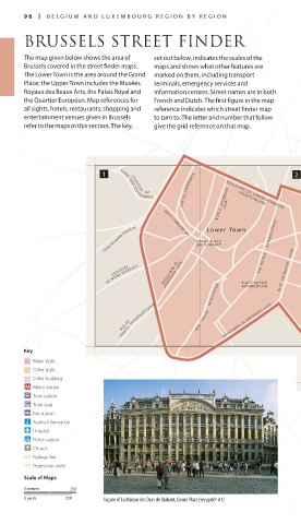
96 bel gium and l uxembourg region b y region
BRUSSELS STREET FINDER
The map given below shows the area of set out below, indicates the scales of the
brussels covered in the street finder maps. maps and shows what other features are
The lower Town is the area around the grand marked on them, including transport
Place; the upper Town includes the musées terminals, emergency services and
royaux des beaux arts, the Palais royal and information centres. Street names are in both
the Quartier européen. map references for French and dutch. The first figure in the map
all sights, hotels, restaurants, shopping and reference indicates which street finder map
entertainment venues given in brussels to turn to. The letter and number that follow
refer to the maps in this section. The key, give the grid reference on that map.
QUE DU COMMERCE BLVD E. JACQMAIN LAAN KRUIDTUINLAAN
CHAUSS E E DE
GAND GENTSEST E E NWEG
BOULEVARD DU JARDIN BOTANIQUE
LEUVENS ESTEENWEG
Canal Bruxelles-Charlerol RUE A. DANSAERT STR. GROTE MARKT RUE ROYALE KONINGSSTRAAT CHAUSSEE DE LOUVAIN
Lower Town
GRAND PLACE
KORTENBERGLAAN
Upper Town
LEMONNIER LAAN
DE MONS BERGENSE BOULEVARD M. PLACE ROYALE BLVD DE REGENT LAAN RUE BELLIARD STRAAT R. SCHUMAN AVE DE CORTENBERG BVD BRAND WHITLOCK LAAN
CHAUSSEE
RUE DE LA LOI WETSTR.
ROND PONT
KONINGSPLEIN
PLEIN
FRANCE FRANKRIJKSTRAAT RUE HAU TE HOOGSTRAAT BOULEVARD DE WATERLOO LAAN AVE DE TERVUREN LAAN
RUE DE
Key AVE DE LA CHASSE JACHTLAAN
Major sight RUE DU TRONE TROONSTRAAT
Other sight
Other building
Metro station
Train station
Tram stop
Bus station
Tourist information
Hospital
Police station
Church
Railway line
Pedestrian street
Scale of Maps
0 metres 250
0 yards 250 Façade of La Maison des Ducs de Brabant, Grand Place (see pp60–61)
096-097_EW_Belgium.indd 96 16/10/14 3:35 pm
Eyewitness Travel LAYERS PRINTED:
Streetfinder intro (Source v1) “UK” LAYER
Date 7th August 2012
Size 125mm x 217mm