
Page 384 - (DK Eyewitness) Travel Guide - London
P. 384
382 STREE T FINDER
STREET FINDER
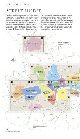
The map references given with all sights, hotels, The key map below shows the area of London
restaurants, shops and entertainment venues covered by the Street Finder, with the postal
described in this book refer to the maps in this codes of the various districts. The maps include
section only (see How Map References Work the sightseeing areas (which are colour-coded),
opposite). A complete index of street names as well as the whole of central London, with all
and all the places of interest marked on the the districts important for hotels, restaurants,
maps can be found on the following pages. pubs and entertainment venues.
Hampstead and Highgate Postal districts are
labelled and outlined
in green.
Regent’s
Park and
Marylebone
Bloomsbury
and Fitzrovia
Smithfield and
Spitalfields
Holborn
and the
Soho and Covent Inns of
Trafalgar Court The City
Square Garden and
the Strand
South Kensington
Piccadilly,
and Knightsbridge Mayfair and Southwark
Kensington and St James's South and Bankside
Bank
Holland Park
Whitehall and
Westminster
Chelsea
Greenwich and
Blackheath
0 kilometres 2
0 miles 1
Key
Postal district boundary
382-383_EW_London.indd 382 21/03/17 3:57 pm