Page 267 - (DK Eyewitness) Travel Guide - Pacific Northwest
P. 267

BRITISH  C OL UMBIA      265


                                                 VISITORS’ CHECKLIST
                                                 Practical Information
                                                 Highway 3. Road Map 2 C4.
                                                 n 225 Hall St, Nelson, (250)
                                                 352-3433. n 2279 Cranbrook
                                                 St N, Cranbrook, (250) 426-5914.
                                                 n 102 Hwy 3, Fernie, (250)
                                                 423-6868. Open all three offices:
                                                 year-round: 9am–5pm Mon–Fri;
                                                 Victoria Day–Labor Day: 10am–
                                                 5pm Sat also.
                                                 ∑ th.gov.bc.ca
                                        . Fernie  ∑ hellobc.com
           This scenic town lies in one of the Kootenays’ most popular areas
           for snow sports. In the 1880s, Fernie was reputedly cursed by an   Transport
                                                 ~ Cranbrook & Castlegar. g BC
            Indian chief when he was betrayed by its founder. In 1964, the
            curse was officially lifted by a peace-pipe-smoking ceremony.  Ministry of Highways inland ferry
                                                 service Kootenay Bay-Balfour,
                                                 year-round, 6:30am–10:20pm
                                                 daily; 35 mins; (250) 229-4215.


        Kimberley
                 Fort Steele
                    Mount Fisher

   Moyie Lake
   Provincial
     Park
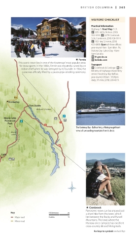
                                         The Kootenay Bay–Balfour ferry, offering magnificent
                                         views of surrounding mountains from its decks
       Moyie
       Lake
     CROWSNEST HIGHWAY


  Yahk


                                              . Cranbrook
                                              Panoramic views can be enjoyed just
       Key                0 kilometers  25    a short hike from this town, which
          Major road      0 miles   15        lies between the Rocky and Purcell
                                              Mountains. This land, where the
          Minor road
                                              Ktunaxa once camped, has excellent
                                              cross-country ski and hiking trails.
                                                  For keys to symbols see back flap


   US_PNW_264-265_Kootenays.indd   265                      04/07/16   12:40 pm
   262   263   264   265   266   267   268   269   270   271   272