
Page 190 - (DK Eyewitness) Travel Guide - Chicago
P. 190
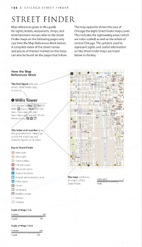
188 CHIC A GO STREE T FINDER
STREET FINDER
Map references given in this guide The map opposite shows the area of
for sights, hotels, restaurants, shops, and Chicago the eight Street Finder maps cover.
entertainment venues refer to the Street This includes the sightseeing areas (which
Finder maps on the following pages only are color-coded) as well as the whole of
(see How the Map References Work below). central Chicago. The symbols used to
A complete index of the street names represent sights and useful information
and places of interest marked on the maps on the Street Finder maps are listed Near North
Side
can also be found on the pages that follow. below in the key.
How the Map Chicago River
References Work WEST FULTON STREET WEST WACKER DRIVE
333 West
Building
Wacker Drive POST PL R.R. Donnelley <<300 Downtown
Clark/ GARVEY CT State/
Clinton WEST LAKE STREET N WELLS ST Lake Lake
James R. N DEARBORN ST Lake
N MORGAN ST
N SANGAMON ST
Thompson
Center Lake
NORTH CANAL ST
The first figure tells you Ogilvie WEST RANDOLPH STREET City Hall Oriental N STATE ST Michigan
Theater
Transportation Center
NORTH JEFFERSON STREET
NORTH DES PLAINES STREET
which Street Finder map NEAR WEST WASHINGTON ST Washington/ NORTH LASALLE ST NOR TH CLARK ST Washington
NORTH PEORIA STREET
NORTH GREEN STREET
NORTH CLINTON ST
NORTH HALSTED STREET
to turn to. WEST SIDE Wells Reliance <<2
Building
WEST MADISON STREET
<<300 <<150
Sullivan
Center
WEST MONROE STREET
Monroe
Marquette 100>>
1 Willis Tower <<800 SOUTH HALSTED STREET SOUTH CANAL STREET Union SOUTH WACKER DRIVE WEST ADAMS STREET
Building
SOUTH SANGAMON ST
SOUTH MORGAN STREET
The Rookery
Willis
Federal
Tower
WEST QUINCY ST
Center
Station
Quincy
SOUTH PEORIA STREET
SOUTH GREEN STREET
SOUTH JEFFERSON STREET
WEST JACKSON BLVD Monadnock
Jackson
SOUTH DES PLAINES STREET
233 S Wacker Dr. Map 3 B2 Tel 875- LaSalle/ Building
SOUTH CLINTON STREET
Harold
Van Buren
W VAN BUREN ST Washington
Library
9696. q Quincy. Open Mar–Sep: UIC- Halsted DAN RYAN EXPWY DAN RYAN EXPRESSWAY Clinton S SHERMAN ST
Library Center
S FRANKLIN ST
9am–11pm daily; Oct–Feb: Greyhound WEST CONGRESS PARKWAY
LaSalle Street
9am–10pm daily; last adm 30 min Bus Terminal WEST HARRISON STREET Harrison
Station
before closing. & 7 = Main Post House Row SOUTH FEDERAL ST SOUTH DEARBORN ST S PLYMOUTH ST
Printing
Office
Historic
Jane Addams SOUTH JEFFERSON STREET SOUTH LASALLE STREET District South Loop
Hull-House SOUTH DES PLAINES STREET SOUTH CLINTON STREET
Museum WEST POLK STREET WEST POLK STREET & Near
Dearborn
Station Galleria
University 800>> South Side
of Illinois
at Chicago SOUTH STATE STREET
SOUTH SHERMAN STREET
The letter and number give SOUTH MORGAN STREET WEST TAY L OR STREET S CLARK STREET SOUTH FEDERAL PARK TER W TAYLOR ST
SOUTH WELLS STREET
Chicago
Fire Academy
the grid reference. Letters go W DEKOVEN
ST
across the map’s top and Roosevelt
SOUTH PLYMOUTH ST
bottom; figures on its sides. W 1 2 T H P L 1200>>
W MAXWELL ST SOUTH CANAL STREET SOUTH FEDERAL ST
W MAXWELL ST SOUTH JEFFERSON STREET
WEST ROOSEVELT ROAD SOUTH PLYMOUTH ST
Key to Street Finder SOUTH HALSTED STREET SOUTH CLIFTON STREET
S O U T H R U B L E S T R E E T
WEST 14TH ST SOUTH ST A TE STREET
WEST 14TH PLACE SOUTH CLARK STREET
Major sight South Branch of Chicago River
WEST 15TH ST
SOUTH UNION A VENUE
Minor sight S SANGAMON STREET SOUTH PEORIA STREET SOUTH NEWBERRY AVENUE Halsted W 15TH ST
Other building WEST 16TH STREET S CLINTON ST S STEWART WEST 16TH ST
CTA train station S RUBE ST ST S DES PLAINES ST S JEFFERSON ST ST S NORMAL S FEDERAL WEST 17TH ST PLYMOUTH
ST
Metra train station
Tourist information
Hospital with emergency room The map continues
on map 5 of the 0 kilometers 2
Police station
Street Finder. 0 mile 1
Church
Synagogue
Buddhist temple
Railroad
Highway
South Side
Scale of Maps 1–6
0 meters 500
0 yards 500
Scale of Maps 7 & 8
0 meters 500
0 yards 500
188-189_EW_Chicago.indd 188 13/07/16 2:56 pm