
Page 61 - (DK Eyewitness) Travel Guide - Chicago
P. 61
DOWNT OWN 59
office tower is sheathed s Wacker Drive
with reflective, green-tinted From N Wacker Dr to N Michigan Ave.
glass that changes shade Map 3 C1. q Clark.
depending on the levels of
sun and water. Broad horizontal Wacker Drive’s east-west
bands of brushed stainless segment offers one of the
steel run every 6 ft (2 m). loveliest downtown walks of
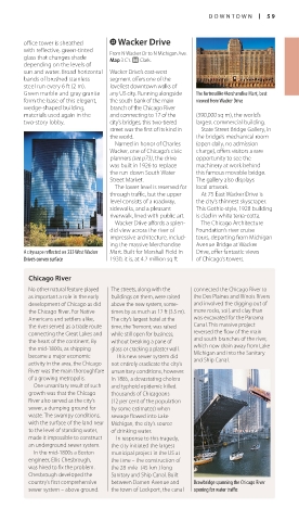
Green marble and gray granite any US city. Running alongside The fortresslike Merchandise Mart, best
form the base of this elegant, the south bank of the main viewed from Wacker Drive
wedge-shaped building, branch of the Chicago River
materials used again in the and connecting to 17 of the (390,000 sq m), the world’s
two-story lobby. city’s bridges, this two-tiered largest commercial building.
street was the first of its kind in State Street Bridge Gallery, in
the world. the bridge’s mechanical room
Named in honor of Charles (open daily, no admission
Wacker, one of Chicago’s civic charge), offers visitors a rare
planners (see p73), the drive opportunity to see the
was built in 1926 to replace machinery at work behind
the run-down South Water this famous movable bridge.
Street Market. The gallery also displays
The lower level is reserved for local artwork.
through traffic, but the upper At 75 East Wacker Drive is
level consists of a roadway, the city’s thinnest skyscraper.
sidewalks, and a pleasant This Gothic-style, 1928 building
riverwalk, lined with public art. is clad in white terra-cotta.
Wacker Drive affords a splen- The Chicago Architecture
did view across the river of Foundation’s river cruise
impressive architecture, includ- tours, departing from Michigan
ing the massive Merchandise Avenue Bridge at Wacker
A cityscape reflected on 333 West Wacker Mart. Built for Marshall Field in Drive, offer fantastic views
Drive’s convex surface 1930, it is, at 4.2 million sq ft of Chicago’s towers.
Chicago River
No other natural feature played The streets, along with the connected the Chicago River to
as important a role in the early buildings on them, were raised the Des Plaines and Illinois Rivers
development of Chicago as did above the new system, some- and involved the digging out of
the Chicago River. For Native times by as much as 12 ft (3.5 m). more rocks, soil, and clay than
Americans and settlers alike, The city’s largest hotel at the was excavated for the Panama
the river served as a trade route time, the Tremont, was raised Canal. This massive project
connecting the Great Lakes and while still open for business, reversed the flow of the main
the heart of the continent. By without breaking a pane of and south branches of the river,
the mid-1800s, as shipping glass or cracking a plaster wall. which now drain away from Lake
became a major economic This new sewer system did Michigan and into the Sanitary
and Ship Canal.
activity in the area, the Chicago not entirely eradicate the city’s
River was the main thorough fare unsanitary conditions, however.
of a growing metropolis. In 1885, a devas tating cholera
One unsanitary result of such and typhoid epidemic killed
growth was that the Chicago thousands of Chicagoans
River also served as the city’s (12 per cent of the population
sewer, a dumping ground for by some estimates) when
waste. The swampy conditions, sewage flowed into Lake
with the surface of the land near Michigan, the city’s source
to the level of standing water, of drinking water.
made it impossible to construct In response to this tragedy,
an underground sewer system. the city initiated the largest
In the mid-1800s a Boston municipal project in the US at
engineer, Ellis Chesbrough, the time – the construction of
was hired to fix the problem. the 28-mile- (45-km-) long
Chesbrough developed the Sanitary and Ship Canal. Built
country’s first comprehensive between Damen Avenue and Drawbridge spanning the Chicago River
sewer system – above ground. the town of Lockport, the canal opening for water traffic
058-059_EW_Chicago.indd 59 13/07/16 2:59 pm