
Page 177 - (DK Eyewitness) Travel Guide - South Africa
P. 177
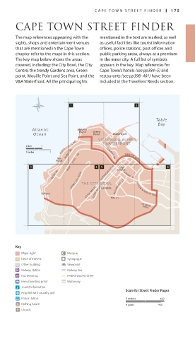
C APE T OWN STREE T FINDER 175
CAPE TOWN STREET FINDER
The map references appearing with the mentioned in the text are marked, as well
sights, shops and entertainment venues as useful facilities like tourist information
that are mentioned in the Cape Town offices, police stations, post offices and
chapter refer to the maps in this section. public parking areas, always at a premium
The key map below shows the areas in the inner city. A full list of symbols
covered, including: the City Bowl, the City appears in the key. Map references for
Centre, the trendy Gardens area, Green Cape Town’s hotels (see pp384–5) and
point, Mouille Point and Sea Point, and the restaurants (see pp398–401) have been
V&A Waterfront. All the principal sights included in the Travellers’ Needs section.
Tabl e
Bay
At lantic Mouille Green
Point
Ocean Point Waterfront
VICTORIA & ALFRED
ROAD WATERFRONT
0 km 1
BEACH
0 miles 1 MAIN RD SOMERSET RD
Sea TABLE BAY BLVD
Point HIGH LEVEL RD City
KLOOF RD BUITENGRAGHT ST Centre STRAND ST
SIGNAL HILL ROAD THE CITY BOWL
BUITENKANT ST
Clifton KLOOF NEK RD KLOOF ST Gardens MILL ST NELSON MANDELA BLVD
DE WAAL
DRIVE
Key
Major sight Mosque
Place of interest Synagogue
Other building Viewpoint
Railway station Railway line
Bus terminus Pedestrianized street
Ferry boarding point Motorway
Tourist information
Scale for Street Finder Pages
Hospital with casualty unit
Police station 0 metres 400
Bathing beach 0 yards 400
Church
174-175_EW_South_Africa.indd 175 25/05/17 2:46 pm