
Page 152 - (DK Eyewitness) Travel Guide - Sydney
P. 152
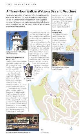
150 SY DNEY AREA B Y AREA
A Three-Hour Walk in Watsons Bay and Vaucluse
Tracing the perimeters of spectacular South Head, this walk weatherboard cottages on your
touches on the area’s Colonial connections and takes in a left, follow the street to its end
variety of ocean and harbourside terrain, from headlands and onto Camp Cove Beach 6.
with sweeping views and crashing waves, to secluded coves, It was here in 1788 that Captain
Arthur Phillip first stepped
white sandy beaches and the streets of one of Sydney’s most ashore after leaving Botany
desirable neighbourhoods. Bay to explore the coastline.
Camp Cove to
The Dunbar’s anchor is set into Watsons Bay
concrete here, while salvaged Take the wooden steps
personal effects are displayed at at the northern end
the Australian National Mari time of the cove to make
Museum (see pp96–7). the 40minute return
Taking the steps down from The walk to South Head.
Gap, bear right into the entrance Above the steps are
of Sydney Harbour National Park. signs of Colonial
This singlelane roadway leads defences: a firing
through natural bushland into wall with rifle
2 Signal Station built in 1848, looking HMAS Watson Military Reserve.
out over Dunbar Head Follow the road up to visit the
Naval Memorial Chapel 5.
Macquarie Lighthouse to A large clear window inside the
Camp Cove chapel offers spectac ular views
The start of this walk is majestic of North Head and the Pacific
Macquarie Lighthouse (1883) Ocean. Resume your walk
1. A copy of the coun by taking the road out
try’s first lighthouse built of the reserve, and then Nudist Lady Bay beach, also known
in 1818 (see p139), it turn right into as Lady Jane beach
stands on the same site. Cliff Street.
Take the walk north Passing a
wards, passing by the row of
Signal Station 2 follow
ing Old South Head 1 Bust, Macquarie
Road. Before the station Lighthouse
was built in 1848, a flag
was hoisted to warn the colony
of ships entering the harbour.
Continue along the footpath,
where a plaque marks the
location of Australia’s worst
maritime disaster. It was here
that the migrant ship Dunbar
crashed onto the rocks in a gale
in 1857 (see pp138–9). The only
survivor was hauled to safety up
the treacherous cleft in the cliff
face known as Jacob’s Ladder 3.
From here, follow the descending
path, arriving at the jutting
stony ledges of The Gap 4.
Key
8 Doyle’s well-known restaurant at Watsons Bay Walk route
150-151_EW_Sydney.indd 150 29/05/17 12:19 pm