
Page 158 - (DK Eyewitness) Travel Guide - Sydney
P. 158
156 BEY OND SY DNEY
1 Pittwater and Ku-ring-gai Chase
Pittwater and the adjacent Ku-ring-gai Chase National Park
lie on Sydney’s northernmost outskirts. They are bounded
to the north by Broken Bay, at the mouth of the Hawkesbury Brisbane Water
National Park
River (see pp158–9). Sparkling waterways and golden beaches
are set against the unspoiled backdrop of the national
park. Picnicking, bushwalking, surfing, boating, sailing
and windsurfing are popular pastimes with visitors. The Patonga
Hawkes bury River system curls around an ancient sandstone
landscape rich in Aboriginal rock art, and flora and fauna.
Flint and
Steel Point
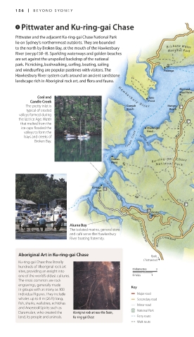
Coal and H a w k e s b u r y R i v e r Juno
Candle Creek Point
The pretty inlet is Gunyah Hungry
typical of eroded Beach Beach Great Mackerel
valleys formed dur ing Beach
the last Ice Age. Water
that melted from the W e s t H e a d R o a d
ice caps flooded the Challenger
valleys to form the Head
bays and creeks of
Broken Bay. C o w a n C r e e k Refuge Bay The Basin
Cowan K u - r i n g - g a i C h a s e
Point
N a t i o n a l P a r k
Towlers Bay
Lovett Bay
Cottage
Point Coal and Candle Creek
McCarrs Creek
Smiths Creek
Akuna
Bay
Akuna Bay
The isolated marina, general store General San Martin Drive
and café serve the Hawkesbury
River boating fraternity.
McCarrs Creek Road
Aboriginal Art in Ku-ring-gai Chase Ryde,
Chatswood
Ku-ring-gai Chase has literally
hundreds of Aboriginal rock art 0 kilometres
sites, providing an insight into 2
one of the world’s oldest cultures. 0 miles 1
The most common are rock
engravings, generally made Key
in groups with as many as 100
individual figures. They include Major road
whales up to 8 m (26 ft) long, Secondary road
fish, sharks, wallabies, echidnas Minor road
and Ancestral Spirits such as
Daramulan, who created the Aboriginal rock art near the Basin, National Park
land, its people and animals. Ku-ring-gai Chase Ferry route
Walk route
156-157_EW_Sydney.indd 156 29/05/17 12:19 pm