
Page 238 - (DK Eyewitness) Travel Guide 2016 - Austria
P. 238
236 A USTRIA REGION b y REGION
u Kaprun Environs: South of Zell am
See is the Hohe Tauern
Road map D4. * 3,000. @
n (06547) 8080. mountain range and national
park (see pp282–5), to the north
Kaprun is a popular winter the rugged scenery of the
sports resort. It is also famous Steiner nes Meer (Stone Sea) and
for its sophisticated hydro electric to the west the Schmittenhöhe,
power station, which is acclaimed divided into the Sonnkogel and
as a wonder of technology and Hirschkogel regions, with its
one of the greatest achieve- highest peak rising to over
ments of human ingenuity. 2,000 m (6,562 ft).
Work on the construction of The Pinz gauer Spaziergang
the Kapruner Ache power is one of the most beautiful
station began in 1938, and was walking trails in the Austrian
completed in 1951. Its highest Alps, running at an altitude of
reservoir is Mooserboden, a about 1,000 m (3,280 ft) above
lake situated at an altitude of the valley floor, from Zell am See
2,036 m (6,680 ft) and fed by Inside St Hippolytus Church in Zell am See to Saalbach, via Schmittenhöhe
the melting ice of the (a seven-hour walk).
Pasterze glacier. i Zell am See
Kaprun power station is not Road map C4. * 9,500. £
only a technological marvel; it is @ Tel (06542) 770. o Saalbach
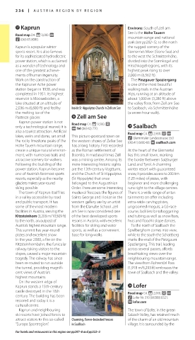
also a tourist attraction. Artificial Road map C4. * 2,900. £ @
lakes, weirs and dams, set amid This picture-postcard town on n Glemmtaler Landesstrasse 550
the rocky limestone peaks of the the western shores of Zeller See (06541) 6800-68. ∑ saalbach.com
Hohe Tauern mountain range, has a long history. First recorded
create a unique natural environ- as the Roman settlement of At the heart of the Glemmtal
ment, with numerous trails and Bisontio, in medieval times Zell lies this small town, marking
attractive scenery for walkers. was a mining centre. Among its the border between Salzburger
Following the building of the more interesting historic sights Land and Tyrol. A charming
power station, Kaprun became are the 13th-century Vogtturm, winter resort with guaranteed
one of Austria’s foremost sports and the Church of St Hippolytus snow, it provides access to 200 km
resorts, especially as the nearby (St Hippolyte) that once (120 miles) of pistes, with
glaciers makes year-round belonged to the Augustinian beginner and more challenging
skiing possible. Order. There are some interesting runs right to the village centres.
The town of Kaprun itself lies medieval frescoes: the figures of There is a wide range of enter-
in a valley accessible by road Saints George and Florian in the tainments on offer including
and public transport. It has western gallery are by an artist extra-wide carving pistes,
some of the most modern from the Danube School. Zell ungroomed moguls, a GS-race
facilities in Austria, serving the am See is now considered one course, facilities for tobogganing
Kitzsteinhorn (3,203 m/10,509 ft) of the best developed sports and tubing as well as snow bars,
to the north, an outpost of resorts in Austria, with excellent huts and flood-lit slope dances.
Austria’s highest mountain range. facilities for skiing and water To the north of Saalbach the
This summit has year-round sports, as well as a convenient Spielberghorn comes into view,
pistes and excellent snow. base for long walks. while to the south the Schattberg
In the year 2000, a fire on the marks the end of the Pinzgauer
Kitzsteinhornbahn, the funicular Spaziergang. This trail, leading
railway taking visitors to the across several passes, affords
slopes, caused a major mountain breathtaking views over the
tragedy. The railway has since neighbouring mountain range.
been re-routed to run outside The view from Rohrertörl Pass
the tunnel, providing magnifi- (1,918 m/6,293 ft) embraces the
cent views of Austria’s town of Saalbach and the valley.
highest mountains.
On the western edge of
Kaprun stands a 15th-century p Lofer
castle destroyed in the 18th Road map C4. * 2,000. £ @
century. The building has been n Lofer Nr. 310 (06588) 8321.
restored and today it is a ∑ lofer.com
cultural centre.
Kaprun and neighbouring The town of Lofer, in the green
ski resorts have joined forces to Salzach Valley, has retained much
attract visitors to this so-called Charming, flower-bedecked houses of the charm of an old mountain
“Europa Sportregion”. in Saalbach village. It is surrounded by the
For hotels and restaurants in this region see pp297–8 and pp322–3
236-237_EW_Austria.indd 236 03/09/15 5:43 pm
Eyewitness Travel LAYERS PRINTED:
Catalogue template “UK” LAYER
(Source v2.1)
Date 5th December 2012
Size 125mm x 217mm