
Page 254 - (DK Eyewitness) Travel Guide 2016 - Austria
P. 254
252 A USTRIA REGION B Y REGION
r Zillertaler Alpen
The Zillertal, the valley of the Ziller river, extends
from Innau to the Austro-Italian border. Initially
a wide upland, beyond Mayrhofen it splits into
four narrower valleys that cut into the mountain
ranges. Artificial lakes and large dams were built
into most of the local rivers to provide a power
supply for the entire region. The present popularity
of winter sports has contributed to the rapid
development of Zillertal. Especially popular with
skiers are the Hintertux Glacier runs, the Mayrhofen-
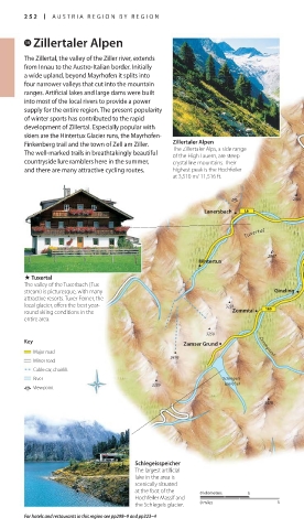
Finkenberg trail and the town of Zell am Ziller. Zillertaler Alpen
The Zillertaler Alps, a side range
The well-marked trails in breathtakingly beautiful of the High Tauern, are steep
countryside lure ramblers here in the summer, crystalline mountains. Their
and there are many attractive cycling routes. highest peak is the Hochfeiler
at 3,510 m/ 11,516 ft.
J 2095
Lanersbach
Finkenberg
Tuxertal
2867
Hintertux
. Tuxertal
The valley of the Tuxerbach (Tux
stream) is picturesque, with many Ginzling
attractive resorts. Tuxer Ferner, the
local glacier, offers the best year- 3231
round skiing conditions in the Zemmtal
entire area.
3250
Key Zamser Grund Zemmgrund 3107
Major road
3476
Minor road
Cable car, chairlift
River Schlegeis-
Viewpoint 3289 speicher 2634
3478
Schlegeisspeicher
The largest artificial
lake in the area is
scenically situated
at the foot of the 0 kilometres 5
Hochfeiler Massif and
the Schlegeis glacier. 0 miles 5
For hotels and restaurants in this region see pp298–9 and pp323–4
252-253_EW_Austria.indd 252 03/09/15 5:30 pm
Eyewitness Travel LAYERS PRINTED:
Starsight template “UK” LAYER
(Source v2.4)
Date 15th January 2013
Size 125mm x 217mm