
Page 349 - (DK Eyewitness) Travel Guide - Portugal
P. 349
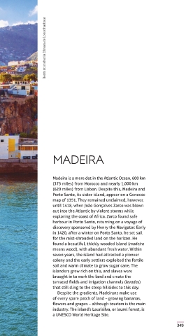
Boats at anchor in Câmara de Lobos’ harbour


                    MADEIRA


                    Madeira is a mere dot in the Atlantic Ocean, 600 km
                    (375 miles) from Morocco and nearly 1,000 km
                    (620 miles) from Lisbon. Despite this, Madeira and
                    Porto Santo, its sister island, appear on a Genoese
                    map of 1351. They remained unclaimed, however,
                    until 1418, when João Gonçalves Zarco was blown
                    out into the Atlantic by violent storms while
                    exploring the coast of Africa. Zarco found safe
                    harbour in Porto Santo, returning on a voyage of
                    discovery sponsored by Henry the Navigator. Early
                    in 1420, after a winter on Porto Santo, he set sail
                    for the mist-shrouded land on the horizon. He
                    found a beautiful, thickly wooded island (madeira
                    means wood), with abundant fresh water. Within
                    seven years, the island had attracted a pioneer
                    colony and the early settlers exploited the fertile
                    soil and warm climate to grow sugar cane. The
                    islanders grew rich on this, and slaves were
                    brought in to work the land and create the
                    terraced fields and irrigation channels (levadas)
                    that still cling to the steep hillsides to this day.
                      Despite the gradients, Madeirans make use
                    of every spare patch of land – growing bananas,
                    flowers and grapes – although tourism is the main
                    industry. The island’s Laurisilva, or laurel forest, is
                    a UNESCO World Heritage Site.
                                                                  349


   348-349_EW_Portugal.indd   349                            20/09/2018   10:42