
Page 28 - Guest Service Directory
P. 28
Inf Inf
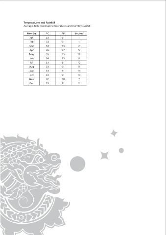
Krabi Province: Temperatures and Rainfall
is located 814 kms. From Bangkok along Highway No.4 via Phetchahuri, Prachuap Kiri Khan, Chumphon, Average daily maximum temperatures and monthly rainfall:
Ranong and Phangnga. Five kilometers before the town, the highway runs parallel to Krabi River featuring
the very beautiful scenery of a river flowing between two mountain ranges. Months ºC ºF Inches
Jan 33 91 1
Krabi is located on the coastline of the Indian Ocean bordering Amphuer Phra Saeng of Surat Thani and Tap
Put of Phangnga to the north, Trang and the Andaman Sea to the south, Nakhon Si Thammarat and Trang to Feb 33 91 1
the east, Phangnga and the Andaman Sea to the west. Mar 34 93 2
Apr 36 97 5
It occupies an area of 4,708 square kilometers, administratively divided into 8 Amphuers or districts: Muang, May 35 95 12
Ao Luk, Khao Phamom, Khlong Thorm, Ko Lanta, Plai Phraya, Lam Thap and Nua Khlong.
Jun 34 93 11
The general geographic condition consists of mountains, hills, plains and more than 130 small islands off the Jul 33 91 12
coast. The still pristine jungles Include white mangrove and mangrove forests. The soil is mostly sandy Clay Aug 33 91 11
and rich loam, perfect for rubber, palm, cashew nut, coffee and Coconut plantations.
Sep 33 91 14
Oct 33 91 13
Local Surroundings:
Phi Phi Island, approximately 1 hour by speed boat (swimming and snorkeling) Nov 32 90 7
Pranang Cave, approximately 10 minutes by speed boat (sight seeing) Dec 33 91 2
Porda Island, approximately 15 minutes by speed boat (swimming, snorkeling & sunbathing)
Chicken Island, approximately 20 minutes by speed boat (swimming and snorkeling)
Krabi Town, approximately 25 minutes by bus (shopping, sight seeing)
Huiyto Waterfall, approximately 1 hour drive (sight seeing)
Hot Spring & Crystal Pool approximately 1.5 hours drive (swimming and sight seeing)
Beach/Public & Long Tail boats:
All beaches in the area are public; therefore please respect the local culture as any form of nudity is not
accepted. Beach conditions can fluctuate from time to time in the year with variances in sea and tide
conditions. Please follow the advice of the marine department’s daily weather and sea conditions for both
swimming and water sports. Please be aware that the long tail boat operators are just that and if you
choose to use their services please be aware of varying charges which can change dramatically all the time.
Jellyfish:
Beware of the Fire Jelly Fish on the high tides from August to October. If stung an uncomfortable burning
sensation will be felt but it is not fatal. Please seek first aid treatment as soon as practical.
Climate:
Thailand has a tropical climate with three seasons:
Rainy Season:
Beware of the Fire Jelly Fish on the high tides from August to October. If stung an uncomfortable burning
sensation will be felt but it is not fatal. Please seek first aid treatment as soon as practical.
Cool Season:
The northeast monsoon comes from Central Asia and usually blows from November to February, bringing
relatively cool, dry conditions to the country.
Hot Season:
Between the 2 monsoons, March to May, the land heats up creating an area of low pressure. Eventually the
high pressure over the Indian Ocean moves inland and the monsoon cycle begins again. The word monsoon
comes from the Arabic maws in or season. It refers to South Asia’s seasonal winds (not the heavy rains).
In Thailand, the southwest monsoon is the rainy season; the northeast monsoon is dry or cool season.
Temperature change is rather minor between the seasons.