
Page 159 - NEWGEN21-Proceedings-Full
P. 159
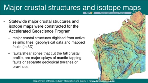
Major crustal structures and isotope maps


    • Statewide major crustal structures and
          isotope maps were constructed for the


          Accelerated Geoscience Program


         – major crustal structures digitised from active
             seismic lines, geophysical data and mapped

             faults (in 3D)


         – faults/shear zones that cut the full crustal

             profile, are major splays of mantle-tapping

             faults or separate geological terranes or
             provinces


                                            Government of Western Australia  Department of Mines and Petroleum
                                            Government of Western Australia  Department of Mines and Petroleum