
Page 10 - Topographical Maps-Indroduction.pmd
P. 10
Practical Work in Geography
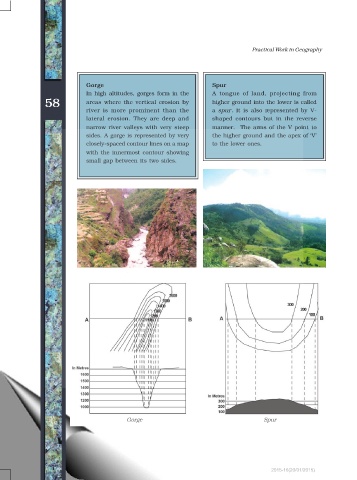
Gorge Spur
In high altitudes, gorges form in the A tongue of land, projecting from
58 areas where the vertical erosion by higher ground into the lower is called
river is more prominent than the a spur. It is also represented by V-
lateral erosion. They are deep and shaped contours but in the reverse
narrow river valleys with very steep manner. The arms of the V point to
sides. A gorge is represented by very the higher ground and the apex of V
closely-spaced contour lines on a map to the lower ones.
with the innermost contour showing
small gap between its two sides.
Gorge Spur
2015-16(20/01/2015)