Page 11 - Topographical Maps-Indroduction.pmd
P. 11

Topographical Maps
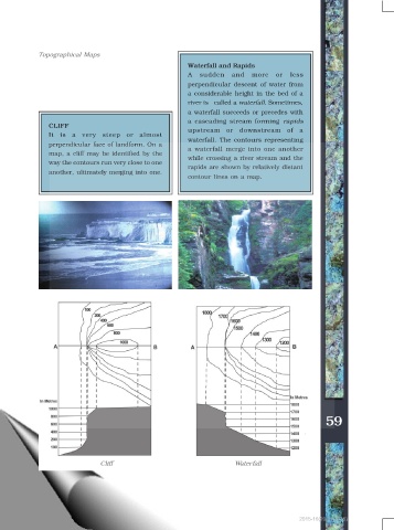
                                                           Waterfall and Rapids
                                                           A   sudden    and   more    or  less
                                                           perpendicular descent of water from
                                                           a considerable height in the bed of a
                                                           river is   called a waterfall. Sometimes,
                                                           a waterfall succeeds or precedes with
                                                           a cascading stream forming rapids
                CLIFF
                                                           upstream or downstream of a
                It is a very steep or almost
                                                           waterfall. The contours representing
                perpendicular face of landform. On a
                                                           a waterfall merge into one another
                map, a cliff may be identified by the
                                                           while crossing a river stream and the
                way the contours run very close to one
                                                           rapids are shown by relatively distant
                another, ultimately merging into one.
                                                           contour lines on a map.


                                                                                                      59


                                Cliff                                     Waterfall


                                                                                              2015-16(20/01/2015)
   6   7   8   9   10   11   12   13   14   15   16