
Page 520 - (DK Eyewitness) Travel Guide - USA
P. 520
518 THE SOUTHWEST
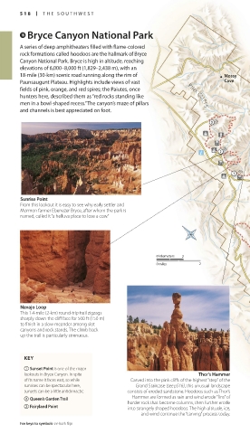
i Bryce Canyon National Park
A series of deep amphitheaters filled with flame-colored
rock formations called hoodoos are the hallmark of Bryce
Canyon National Park. Bryce is high in altitude, reaching
elevations of 6,000–8,000 ft (1,829–2,438 m), with an
18-mile (30-km) scenic road running along the rim of Mossy
Paunsaugunt Plateau. Highlights include views of vast Cave
fields of pink, orange, and red spires; the Paiutes, once
hunters here, described them as “red rocks standing like PINK CLIFFS
men in a bowl-shaped recess.” The canyon’s maze of pillars
and channels is best appreciated on foot. J
J
J
J
Paria
View
Sunrise Point
From this lookout it is easy to see why early settler and
Mormon farmer Ebenezer Bryce, after whom the park is PINK CLIFFS
named, called it “a helluva place to lose a cow.”
0 kilometers 2
0 miles 2
Navajo Loop
This 1.4-mile (2-km) round-trip trail zigzags
sharply down the cliff face for 500 ft (150 m)
to finish in a slow meander among slot
canyons and rock stands. The climb back
up the trail is particularly strenuous.
KEY
1 Sunset Point is one of the major
lookouts in Bryce Canyon. In spite Thor’s Hammer
of its name it faces east, so while Carved into the pink cliffs of the highest “step” of the
sunrises can be spectacular here, Grand Staircase (see p516), this unusual landscape
sunsets can be a little anticlimactic. consists of eroded sandstone. Hoodoos such as Thor’s
Hammer are formed as rain and wind erode “fins” of
2 Queen’s Garden Trail harder rock that become columns, then further erode
3 Fairyland Point into strangely shaped hoodoos. The high altitude, ice,
and wind continue the “carving” process today.
For keys to symbols see back flap
518-519_EW_USA.indd 518 11/2/16 2:47 PM
Eyewitness Travel LAYERS PRINTED:
Starsight template “UK” LAYER
(Source v2.7)
Date 24th April 2013
Size 125mm x 217mm