
Page 533 - (DK Eyewitness) Travel Guide - USA
P. 533
ARIZ ONA 531
North Rim VISITORS’ CHECKLIST
The North Rim receives
roughly one-tenth the number Practical Information
of visitors of the South Rim. n Mather Point, Tel (928) 638-
While less accessible, it is a 7888. Open South Rim: daily;
more peaceful destin ation North Rim: summer only. Mule
offering a sense of unexplored rides: South Rim: book ahead (303)
wilderness. Hikes include the 297-2757; North Rim: register at
North Kaibab Trail, a steep Grand Canyon Lodge (435) 679-
two-day descent down to 8665. Closed North Rim facilities:
Phantom Ranch, the only mid-Oct–mid-May. & 7 partial.
lodge on the canyon floor. 8 - = 0 ∑ nps.gov/grca
Transport
k Grand Canyon Airpt., Tusayan.
£ Grand Canyon Railway from
Williams. @ Flagstaff & Williams.
Bright Angel Trail
Used by both Native Americans and early
settlers, the Bright Angel Trail follows a natural
route along one of the canyon’s enormous
fault lines. It is an appealing option for day-
hikers; unlike some other trails in the area,
it offers plenty of shade and several
seasonal water sources.
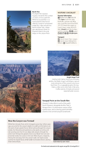
Yavapai Point at the South Rim
Situated 5 miles (8 km) north of the park’s
South Entrance, alongside the Rim Trail, is
Yavapai Point. Its observation station offers
superb views, and a viewing panel identifies
several of the central canyon’s landmarks.
How the Canyon was Formed
While the Colorado River, which changed course four million years
ago, accounts for the canyon’s depth, its width and formations are
the work of even greater forces. Wind rushing through the canyon
erodes the limestone and sandstone a few grains at a time, and
rain pouring over the rim cuts deep side canyons through the
softer rock. Perhaps the greatest force is ice. Water from rain and
snowmelt works into cracks in the rock. When frozen, it expands,
forcing the rock away from the canyon walls. Soft layers erode
quickly into sloped faces, while harder rock resists erosion, leaving
sheer vertical faces. Cracks formed by water erosion
For hotels and restaurants in this region see pp550–52 and pp553–5
530-531_EW_USA.indd 531 11/2/16 2:47 PM