
Page 245 - (DK Eyewitness) Travel Guide - Argentina
P. 245
P A T A GONIA 243
VISITORS’ CHECKLIST
Key
Highway Practical Information
Minor road Road map B4.
Park boundary 95 miles (153 km) SW of
Bariloche. n San Martín 24,
International border Bariloche, (0294) 442-3111.
Provincial boundary & 8 0 ® Note: the
best time to go is from Dec to
Mar; ski ing is late Jun to Aug;
trek king is from Dec to Mar;
Isla Victoria and fishing is from Nov to Apr.
This is a forested island famous for Snow is common between
Lago its 2,000-year-old rock paintings. May and Sep.
Falkner ∑ parques nacionales.gov.ar
Caleufú
Transport
k Bariloche.
@ from Bariloche.
Lago Neuquén
Traful
Villa
Traful
Valle
Villa Encantado
Osorno La Angostura
NEUQUÉN
Parque Nacional
Los Arrayanes
. Llao Llao Hotel and Resort
Open since 1938, this hotel (see p282) features a golf
Isla course, private beach, and fantastic views of three lakes.
Victoria Its restaurant is open to non-guests.
Nahuel
Huapi
Lago Nahuel
Puerto Huapí Villa Cerro Catedral
Blest Patagonia’s premier
ski desti nation, this
Llao resort owes its name
Llao to the peak of Cerro
Catedral. Other
San Carlos
Cerro Lopez de Bariloche act ivities are hiking
6,811 ft Bariloche and paragliding.
Villa Cerro
Catedral
Cerro
Cerro Tronador Catedral
11,400 ft 7,835 ft Cruce Andino
RÍO NEGRO
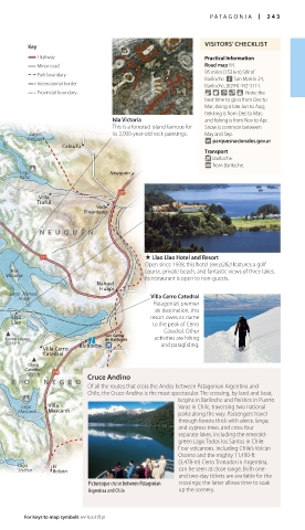
Of all the routes that cross the Andes between Patagonian Argentina and
Chile, the Cruce Andino is the most spectacular. The crossing, by land and boat,
begins in Bariloche and finishes in Puerto
CHILE Lago Villa Varas in Chile, traversing two national
Mascardi Mascardi
Lago parks along the way. Pass engers travel
Roca through forests thick with alerce, lenga,
and cypress trees, and cross four
separate lakes, inclu ding the emerald-
green Lago Todos los Santos in Chile.
Río Manso
Four vol canoes, including Chile’s Volcán
Lago Osorno and the mighty 11,400-ft
Martín (3,478-m) Cerro Tronador in Argentina,
Lago El
Steffen Bolsón can be seen at close range. Both one-
and two-day tickets are available for the
Picturesque cruise between Patagonian crossings; the latter allows time to soak
Argentina and Chile up the scenery.
For keys to map symbols see back flap
242-243_EW_Argentina.indd 243 05/08/16 10:42 am