
Page 252 - (DK Eyewitness) Travel Guide - Argentina
P. 252
250 ARGENTINA REGION B Y REGION
% Lago San Martín
Road map B5. 138 miles (222 km) N of
Tres Lagos. * 500. @ from El Chaltén.
n Ave Güemes 21, El Chaltén,
(02962) 493-370. ∑ elchalten.com
Straddling the border between
Argentina and Chile, where it is
known as Lago O’Higgins, this
lake derives its two names from
the popular Indepen dence
heroes of the two countries,
who united forces in the early
19th cen tury to defeat Spain.
Lago San Martín marks the
starting point of the Austral,
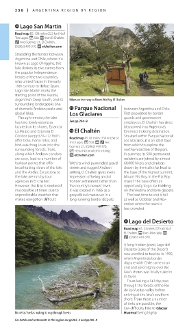
Argentina’s Deep South, and its Hikers on their way to Mount Fitz Roy, El Chaltén
surrounding landscape is one
of dramatic Andean peaks and ^ Parque Nacional between Argentina and Chile.
glacial lakes. Los Glaciares First populated by border
Though remote, the lake guards and government
has two lovely estancias See pp 254–9. employees, El Chaltén has since
located on its shores, Estancia blossomed into Argentina’s
La Maipú and Estancia El & El Chaltén foremost trekking destination.
Cóndor (see pp310–11). Both Road map A5. 81 miles (130 km) W of Situated within Parque Nacional
offer treks, horse rides, and Tres Lagos. * 500. @ n Ave Los Glaciares, it is an ideal base
bird-watching tours into the Güemes 21, (02962) 493-370. from which to explore the
surrounding forests. Trails, _ Fiesta Nacional del Trekking. northern sec tion of the park.
along which Andean condors ∑ elchalten.com In summer, its 500 permanent
are seen, lead to a number of residents are joined by almost
lookout points that offer With its wind-pummeled gravel 60,000 hikers and climbers
breathtaking views of the lake streets and rugged Andean drawn by the trails that lead to
and the Andes. Excursions to setting, El Chaltén gives every the base of the highest summit,
the lake are run by tour impression of being an old Mount Fitz Roy, in the Fitz Roy
agencies in El Chaltén. frontier settle ment rather than massif. The base offers an
However, the lake is rendered the country’s newest town. opportunity to go ice-trekking
inaccessible at times due to It was created in 1985 as a on the Viedma and Torre glaciers.
unpredictable weather that geopolitical maneuver in a The best time to visit is fall
makes navigation difficult. long-running border dispute as well as October and Nov-
ember when the town is
less crowded.
* Lago del Desierto
Road map A5. 23 miles (37 km) N of
El Chaltén. g Dec–Mar daily. @
n (02962) 493-370.
A long-hidden jewel, Lago del
Desierto (Lake of the Desert)
was unveiled to tourists in 1995,
when Argentina’s border
dispute with Chile came to an
end and sover eignty over the
lake’s shores was finally ruled in
its favor.
Tours lasting a full day pass
through the forests of the Río
de las Vueltas valley before
arriving at the lake’s southern
shore. From there a number
of treks are possible, the
low-difficulty hike to Glaciar
Río de las Vueltas making its way through forests Huemul being highly
For hotels and restaurants in this region see pp282–3 and pp296–8
250-251_EW_Argentina.indd 250 05/08/16 10:42 am
Eyewitness Travel LAYERS PRINTED:
Catalogue template “UK” LAYER
(Source v2.6)
Date 12th July 2013
Size 125mm x 217mm