
Page 373 - (DK Eyewitness) Travel Guide - Australia
P. 373
THE Y ORKE AND EY RE PENINSULAS 371
wilderness has exposed cliffs,
sheltered sandy beaches, rich
birdlife and fantastic fishing.
Wildflowers in the park can be
quite spectacular from early
spring to early summer.
There are several scenic drives
through the park, but some roads
are accessible to 4WD vehicles
only. A favourite route for con-
ventional vehicles is the Yangie
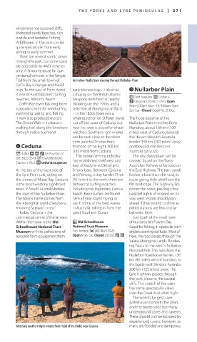
Trail from the small town of An Indian-Pacific train crossing the vast Nullarbor Plain
Coffin Bay to Yangie and Avoid
bays. To the east of Point Avoid early pioneer days. It also has eNullarbor Plain
is one of Australia’s best surfing a display on the British atomic £ Port Augusta. @ Ceduna.
beaches, Almonta Beach. weapons tests held at nearby n Ceduna (08) 8625 3343. Open
Coffin Bay town has long been Maralinga in the 1950s, and a 9am–5:30pm Mon–Fri, 9:30am–5pm
a popular centre for windsurfing, selection of Aboriginal artifacts. Sat–Sun. Closed Good Fri, 25 Dec.
swimming, sailing and fishing. In the 1850s, there was a
It now also produces oysters. whaling station on St Peter Island, The huge expanse of the
The Oyster Walk is a pleasant just off the coast of Ceduna, but Nullarbor Plain stretches from
walking trail along the foreshore now the town is a base for whale- Nundroo, about 160 km (100
through native bushland. watchers. Southern right whales miles) west of Ceduna, towards
can be seen close to the shore the distant Western Australia
from June to October from border 330 km (200 miles) away,
wCeduna the head of the Bight, 300 km and beyond into Western
(185 miles) from Ceduna. Australia (see p323).
* 3,480. ~ @ n 58 Poynton St
(08) 8625 3343. _ Oysterfest (end The oyster-farming industry This dry, dusty plain can be
Sep/early Oct). ∑ ceduna.sa.gov.au has established itself west and crossed by rail on the Trans-
east of Ceduna at Denial and Australian Railway or by road on
At the top of the west side of Smoky bays. Between Ceduna the Eyre Highway. The train travels
the Eyre Peninsula, sitting on and Penong, a tiny hamlet 73 km further inland than the road, its
the shores of Murat Bay, Ceduna (45 miles) to the west, there are route giving little relief from the
is the most westerly significant detours to surfing beaches flat landscape. The highway lies
town in South Australia before including the legendary Cactus nearer the coast, passing a few
the start of the Nullarbor Plain. Beach. Keen surfers are found isolated sights of interest on its
The town’s name comes from here all year round trying to way west. Visitors should plan
the Aboriginal word cheedoona, catch some of the best waves ahead if they intend to drive as
meaning “a place to rest”. in Australia, rolling in from the petrol stations are few and far
Today, Ceduna is the great Southern Ocean. between here.
commercial centre of the far west. Just south of the small town
Within the town is the Old P Old Schoolhouse of Nundroo lies Fowlers Bay.
Schoolhouse National Trust National Trust Museum Good for fishing, it is popular with
Museum with its collections of Park Terrace. Tel (08) 8625 2929. anglers seeking solitude. West of
restored farm equipment from Open Mon–Sat. Closed 25 Dec. & 7 here, the road passes through the
Yalata Aboriginal Lands. Border-
ing Yalata to the west is Nullarbor
National Park. This runs from the
Nullarbor Roadhouse hamlet, 130
km (80 miles) west of Nundroo, to
the border with Western Australia
200 km (125 miles) away. The
Eyre Highway passes through
the park, close to the coastal
cliffs. This stretch of the plain
has some spectacular views
over the Great Australian Bight.
The world’s longest cave
system runs beneath the plain,
and the border area has many
underground caves and caverns.
These should only be explored by
experienced cavers, however, as
Watching southern right whales from Head of the Bight, near Ceduna many are flooded and dangerous.