
Page 88 - (DK Eyewitness) Top 10 Travel Guide - Corfu & the Ionian Islands
P. 88
86 ❯❯ Corfu and the Ionian Islands Area by Area
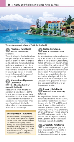
The pretty waterside village of Fiskárdo, Kefalloniá
Skála, Kefalloniá
Fiskárdo, Kefalloniá
5 7
MAP J6 • Southeast coast,
MAP H4 • North coast,
Kefalloniá Kefalloniá
The only village in Kefalloniá to have An attractive town on the southeastern
escaped damage in the 1953 earth- tip of the island, Skála offers a good
quake, Fiskárdo is home to original choice of sandy beaches, restaurants,
pastel-coloured Venetian buildings, hotels, attractions for children, shops
and a busy marina and ferry dock. and nightlife. The earth quake of 1953
Seafood res taurants, tavernas and destroyed much of the town’s original
bars ensure its popularity. Surrounded architecture, the remains of which can
by a landscape clothed in cypress still be seen. A short distance from
trees, it offers won derful views of the town are beautiful pine forests,
neighbouring island Ithaki. and further inland you will find the
Roman Villa, an archaeo lo gical site
Mazarakata Mycenean
6 with some well-preserved mosaics
Cemetery
that once adorned the floor of an
MAP H6 • 9 km (6 miles) SE of impres sive mansion.
Argostóli, Kefalloniá
Lixoúri, Kefalloniá
Discovered in 1908, this ancient 8
cemetery is considered to be the MAP G5 • Pallikí peninsula,
largest Mycenean graveyard found Kefalloniá
on the island to date. It has revealed An elegant town that can trace its
17 subterranean chamber tombs history back to before Venetian times,
carved into the natural rock. They Lixoúri has steadily flourished over
were found intact, filled with the years. In the 19th and 20th cent-
colourful amphorae, glass vessels uries, it was a holiday destination
and other burial offerings. favoured by writers, poets and the
Greek royal family. Today, after many
of its buildings were rebuilt following
EARTHQUAKES IN THE IONIANS the 1953 earthquake, Lixoúri is the
The Ionians lie on a major geological island’s second largest community
fault, where the European and Aegean after Argostóli. It sits on the Pallikí
tectonic plates meet. Tension between Peninsula opposite the capital.
the plates creates ongoing seismic
Argostóli, Kefalloniá
activity; this is usually minor, but a few 9
times each century, earthquakes occur. A charming town lying in a
The largest in recent years, at 7.2 on the large bay, Argostóli is the capital of
Richter scale, was on 12 August 1953.
Its epicentre lay just off Kefalloniá. Kefalloniá (see pp26–7). Life here
revolves around the central square,
084-087_Top_10_Corfu.indd 86 27/11/2017 17:32