
Page 53 - (DK Eyewitness) Travel Guide - Cuba
P. 53
Nature Trails ❮❮ 51
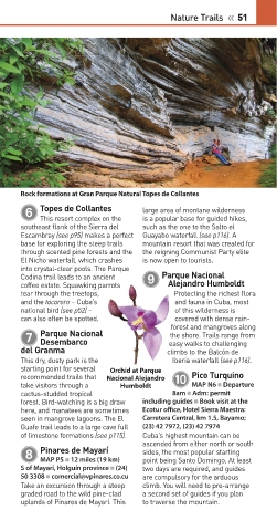
Rock formations at Gran Parque Natural Topes de Collantes
Topes de Collantes
6 large area of montane wilderness
is a popular base for guided hikes,
This resort complex on the
southeast flank of the Sierra del such as the one to the Salto el
Escambray (see p95) makes a perfect Guayabo waterfall (see p116). A
base for exploring the steep trails mountain resort that was created for
through scented pine forests and the the reign ing Communist Party elite
El Nicho waterfall, which crashes is now open to tourists.
into crystalclear pools. The Parque
Parque Nacional
Codina trail leads to an ancient 9
coffee estate. Squawk ing parrots Alejandro Humboldt
tear through the tree tops, Protecting the richest flora
and the tocororo – Cuba’s and fauna in Cuba, most
national bird (see p52) – of this wilderness is
can also often be spotted. covered with dense rain
forest and man groves along
Parque Nacional
7 the shore. Trails range from
Desembarco
easy walks to challenging
del Granma climbs to the Balcón de
This dry, dusty park is the Iberia waterfall (see p116).
starting point for several Orchid at Parque
Pico Turquino
recommended trails that Nacional Alejandro 0
take visitors through a Humboldt MAP N6 • Departure
cactusstudded tropical 8am • Adm: permit
forest. Birdwatching is a big draw including guides • Book visit at the
here, and manatees are sometimes Ecotur office, Hotel Sierra Maestra:
seen in mangrove lagoons. The El Carretera Central, km 1.5, Bayamo;
Guafe trail leads to a large cave full (23) 42 7972, (23) 42 7974
of limestone formations (see p115). Cuba’s highest mountain can be
ascended from either north or south
Pinares de Mayarí
8 sides, the most popular starting
point being Santo Domingo. At least
MAP P5 • 12 miles (19 km)
S of Mayarí, Holguín province • (24) two days are required, and guides
50 3308 • comercial@vpinares.co.cu are compulsory for the arduous
Take an excursion through a steep climb. You will need to prearrange
graded road to the wild pineclad a second set of guides if you plan
uplands of Pinares de Mayarí. This to traverse the mountain.
050-051_Top_10_Cuba.indd 51 08/08/2016 09:52