
Page 182 - (DK Eyewitness) Travel Guide - Ireland
P. 182
180 IRELAND REGION B Y REGION
Exploring Cork
One of Cork’s great attractions is that it is a city built on water.
Its heart lies on an island between two arms of the River Lee,
and many of today’s streets were in fact once waterways lined
with warehouses and merchants’ residences. Although the
Dutch canalside appearance has faded, picturesque quays
and bridges remain. Steep lanes rise to the north and south
of the central island to the city’s 19th-century suburbs,
offering wonderful views of the city and its fine buildings.
The Quays meeting place. From Sullivan’s
Although the river now plays Quay an elegant footbridge,
only a minor part in the city’s built in 1985, crosses the river to
economy, much of Cork’s the south end of Grand Parade.
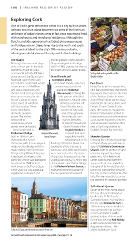
commercial activity still takes Selling fruit and vegetables at the
place around the Quays (pro Grand Parade and English Market
nounced “kays” in the Cork St Patrick’s Street
accent). The South Mall, which On Grand Parade, also once Paul Street
covers an arm of the River a waterway, stands the Noted for its ethnic restaurants,
Lee, was a water way until grandiose National chic bars, bookshops and trendy
the late 18th century. Boats Monument, recalling the boutiques, Paul Street is the hub
were once moored at the Irish patriots who died of the liveliest district in town.
foot of a series of stone between 1798 and 1867. Just off Paul Street are the busy
steps, some of which are Bishop Lucey Park, off backstreets of Carey’s Lane and
still intact today. These Grand Parade, has a French Church Street. In the
led to mer chants’ section of city walls early 18th century, Huguenots
domestic quarters and a fine gateway (French Protestants) settled in
above. The arches from the old corn these streets and set themselves
below led to market. Between up as butter exporters, brewers
warehouses where St Patrick’s Street and and wholesale merchants. This
goods were unloaded. Grand Parade is the area is Cork’s equivalent to
Near South Mall is English Market, a Dublin’s Temple Bar (see p82).
Parliament Bridge, National Monument, covered fruit and
built in 1806 to com Grand Parade vegetable market Shandon Quarter
memorate the Act of established in 1610. Crossing the Christy Ring Bridge
Union (see p46). It is an elegant, Bustling St Patrick’s Street, the to Pope’s Quay, you will see on
singlearched bridge which is backbone of the city, was a your left St Mary’s Dominican
made mainly from limestone. waterway until 1800 when boats Church, with its portico of Ionic
Designed by William Hargrave, were moored under the steps columns topped by a huge
it replaced a bridge on the of gracious houses such as the pediment. John Redmond
same site which was damaged Chateau Bar (see p327). At the top Street leads to the northern
by a flood in 1804. A short of the street, near Patrick Bridge, slopes of Cork, dominated by
walk away, on Sullivan’s Quay, is the Father Mathew Statue, a the spire of St Anne’s Shandon
is the Quay CoOp, a popular monument to the founder of (see p178) with its fine views of
vegetarian restaurant and the Temperance Movement. the city. To the northeast lies the
lofty Montenotte district, once
the epitome of Victorian gentility.
St Fin Barre’s Quarter
South of the river, rising above
the city, this area’s distinctive
landmark is St Fin Barre’s
Cathedral (see p179). Nearby is
the ivyclad Elizabeth Fort, a
16thcentury structure which
was converted into a prison
in 1835 and later a Garda
(police) station. A short walk
to the east lies the Red Abbey,
a 13thcentury relic from an
Augustinian abbey – the
St Patrick’s Quay on the north channel of River Lee oldest building in Cork.
For hotels and restaurants in this region see pp298–9 and pp313–16
180-181_EW_Ireland.indd 180 08/03/17 11:06 am
Eyewitness Travel LAYERS PRINTED:
Catalogue template “UK” LAYER
(Source v1.9)
Date 20th August 2012
Size 125mm x 217mm