Page 62 - (DK Eyewitness) Travel Guide - Brittany
P. 62

60      BRIT T AN Y  REGION  B Y  REGION

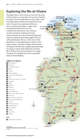
       Exploring the Ille-et-Vilaine

       This département, which covers an area of 6,758 sq km
       (2,608 sq miles), is named after the two rivers that flow   SENTIER DES  POINTE
                                                   DOUANIERS
       through it: the Ille and the Vilaine. In the north, a hilly   DU GROUIN
       area culminating in Mont-Dol overlooks the coast.   Rothéneuf  CANCALE
                                                                           LE MONT-
       East of Cancale, the marshlands of Dol have   DINARD                ST-MICHEL
                                                   ST-MALO
       been converted into polders, sunken areas   ST-LUNAIRE  RANCE   BAIE DU MONT-
                                                                ST-MICHEL
       of land reclaimed from the sea. The   ST-BRIAC  VALLEY  Le Vivier-
                                                            sur-Mer
       coastline then descends to trace a bay out   Châteauneuf d’Ille  Cherrueix
       of which rises Mont-St-Michel. From the    et Vilaine  MONT-DOL    Pontorson  Caen
       Pointe du Grouin, the Côte d’Émeraude (Emerald   DOL-DE-BRETAGNE
       Coast) is marked by alternating jagged cliffs and    Dinan  MENHIR DU         Caen
       soft sandy beaches. Rennes, in the centre of the   CHAMP-DOLENT
       département, is the administrative capital. On the    Château de Landal  Antrain        Louvigné-
                                                                                               du-Désert
       eastern border of the Ille-et-Vilaine, the fortresses    Dinan
       of Fougères and Vitré face neighbouring Normandy.   COMBOURG                   Le Châtellier
       Occupying a corner of the Morbihan and of the    Château de la            Saint-Brice-
                                                                                  en-Coglès
                                                    Bourbansais
       Ille-et-Vilaine, the Forêt de Paimpont is a vestige
       of Argoat, the woodland that once covered the                                              FOUGÈRES
       whole of inland Brittany.                             TINTÉNIAC        Sens-de-
                                       St-Brieuc  BÉCHEREL                    Bretagne
                                                               HÉDÉ  Canal d’Ille          Couesnon    Mayenne
       Sights at a Glance                     Château de  Les Iffs        Saint-Aubin-
                                               Caradeuc
       1 Rennes pp62–7                                                    d'Aubigné   Saint-Aubin-
                                                                                      du-Cormier
       2 Paimpont                                          ILLE-ET -  VILAINE
       3 Forêt de Paimpont       Loudéac       Montauban-de-
                                               Bretagne
       4 Redon                   Saint-Méen-                                   Liffré
       5 Langon                   le-Grand
       6 Grand-Fougeray
       7 La Guerche-de-Bretagne                                          Cesson-Sévigné  Champeaux  VITRÉ  CHÂTEAU DES
       8 Vitré                             Montfort-sur-Meu    RENNES            Châteaubourg     ROCHERS-SÉVIGNÉ
       9 Château des Rochers-Sévigné                                                  Villaine
       0 Fougères                   Comper           Mordelles                                     Argentré-  Laval
       q Hédé                      FORÊT DE PAIMPONT                            Châteaugiron       du-Plessis
       w Bécherel                                                Châtillon-
       e Tinténiac                        PAIMPONT               sur-Seiche
       r Combourg         Tréhorenteuc  Forges-de-  Plélan-le-Grand  Guichen
       t Dol-de-Bretagne            Paimpont  Coëtquidan                       Janzé  Seiche
       y Menhir du Champ-Dolent                                                       La Roche-  LA GUERCHE-
       u Mont-Dol                     Ploërmel                                        aux-Fées  DE-BRETAGNE
       i Baie du Mont-St-Michel            Guer                                        Retiers
       o Mont-St-Michel pp78–81
       a Cancale                                   Lohéac      Bain-de-
       s Pointe du Grouin                                      Bretagne  Semnon     Martigné-
       d St-Malo pp84–9                                                             Ferchaud  Étang de la
                                                                                            Forge
       f Rance Valley                             Pipriac  Vilaine
       g Dinard
       h St-Lunaire                          Landes de  St Just  GRAND-                  Châteaubriant
       j St-Briac                             Coujoux         FOUGERAY
                                                   LANGON
       Hike
       p Sentier des Douaniers
                                                               Nantes
                                              REDON
       0 kilometres    20               St Nazaire
       0 miles                   20
       For hotels and restaurants see pp224–5 and pp234–5


   060-061_EW_Brittany.indd   60                             11/3/16   12:41 PM
   57   58   59   60   61   62   63   64   65   66   67