
Page 98 - (DK Eyewitness) Travel Guide - Brittany
P. 98
96 BRIT T AN Y REGION B Y REGION
1 Mûr-de-Bretagne it attracts lovers of the great
outdoors. From the banks of the
Road map D2. 17 km (11 miles)
west of Loudéac via the N164. Blavet, there is a stunning view of
* 2,140. n Place de l’Église; (02) 96 the Barrage de Guerlédan, which is
28 51 41. ( Jul–Aug: Fri. not open to the public. The power
∑ lacdeguerledan.com station is open to visitors however.
The Musée de l’Électricité
The town of Mûr-de-Bretagne nearby illustrates the history of
marks the linguistic boundary electricity production, and the
between the Celtic, western ways in which electricity is used. Abbaye Cistercienne de Bon-Repos, founded
part of Brittany and the Southwest of the lake is the in the 12th century and now partly in ruins
eastern part. 3,000-ha (7,400-acre) Forêt de
The menhirs in the vicinity, Quénécan, with beech, spruce R Abbaye Cistercienne de
especially the Neolithic Men hir and pine. Like the Forêt de Bon-Repos
de Botrain and the privately- Paimpont, it is a vestige of the St-Gelven. Via the N164. Tel (02) 96 24
owned Menhir de Boconnaire, Forêt de Brocéliande (see p68). 82 20. Open Mar–Jun & Sep–Nov:
as well as the numerous burial Mon–Fri, Sun pm; Jul–Aug: daily. &
mounds, show that the region E Musée de l’Électricité
was quite densely populated St-Aignan. Tel (02) 97 27 51 39.
in prehistoric times. Open Apr, May & Oct: Mon–Sat; 4 Guingamp
The Chapelle Ste-Suzanne, Jun–Sep: daily. & 8 obligatory Road map C2. * 8,830. n 2 Place au
north of Mûr, in a stand of oak Champ-au-Roy; (02) 96 43 73 89. £
trees, was painted by Corot 3 Gorges de @ St-Brieuc. ( Fri & Sat. _ Bugale
(1796–1875). It was built in Breizh (Breton dancing and Pardon de
1496, although the choir Daoulas Notre-Dame, early Jul); Fête de la
(1694) and belfry (1752–64) Road map D2. 30 km (18.5 miles) St-Loup (mid-Aug). ∑ ot-guingamp.fr
are later. west of Loudéac via the N164.
Standing at a crossroads and
The high escarpments and once fortified, Guingamp is an
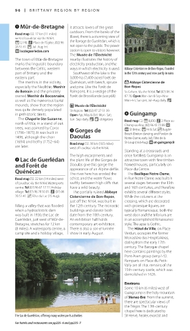
2 Lac de Guerlédan the plant life of the Gorges de attractive town with fine timber-
and Forêt de Daoulas give this gorge the framed houses, parti cularly on
Quénécan appearance of an Alpine defile. Place du Centre.
The Basilique Notre-Dame,
The river here has eroded the
Road map D2. 22 km (14 miles) west schist, and the water flows in Rue Notre-Dame, was built in
of Loudéac via the N164. Watersports swiftly between high cliffs that several stages between the 13th
centre: Tel (02) 96 67 12 22. Holiday have a wild beauty. and 16th centuries, and therefore
village: Tel 02) 96 28 50 01. n (02) 96 The partially ruined Abbaye exhibits several dif ferent styles.
28 51 41. _ Fête du Lac (15 Aug). Cistercienne de Bon-Repos, While the columns at the
just off the N164, was built in crossing, which are decorated
Filling a valley that was flooded the 12th century. The monastic with grotesque figures, are
when a hydroelectric dam buildings and cloister both typically Roman esque, both the
was built in 1930, the Lac de date from the 18th century. west door and the triforium are
Guerlédan, just west of Mûr-de- An exhibition hall holds in an accomplished Renaissance
Bretagne, stretches for 12 km contemporary art exhibition. style. The apse is Gothic.
(8 miles). A watersports centre, a There is also a son et lumière The Hôtel de Ville, on Place
camp site and a holiday village, show in early August. Verdun, occupies the former
Monastère des Hospi talières,
dating from the early 17th
century. The Baroque chapel
here contains paintings by the
Pont-Aven group (see p175).
Ramparts on Place du Petit-
Vally are all that remains of the
15th-century castle, which was
demolished in 1626.
Environs
Some 10 km (6 miles) west of
Guingcamp is the holy mountain
of Menez-Bré. From the summit,
there are spectacular views of
the Trégor. The 17th-century
chapel here is dedicated to
The Lac de Guerlédan, offering many watersports activities St Hervé, healer, exorcist and
For hotels and restaurants see pp225–6 and pp235–7
096-097_EW_Brittany.indd 96 11/3/16 1:02 PM