
Page 126 - (DK Eyewitness) Travel Guide - Washington, DC
P. 126
124 W ASHINGT ON , DC AREA B Y AREA
bottom floors are office
complexes, restaurants, and
shops. Sightseeing boats dock
at the river’s edge for trips to
Mount Vernon and Alexandria.
The spring of 2011 saw severe
flood ing to the Harbour, which
caused considerable damage.
However, with new floodgates
in place, Hurricane Sandy did
not damage the waterfront
in 2012.
2 Wisconsin Avenue
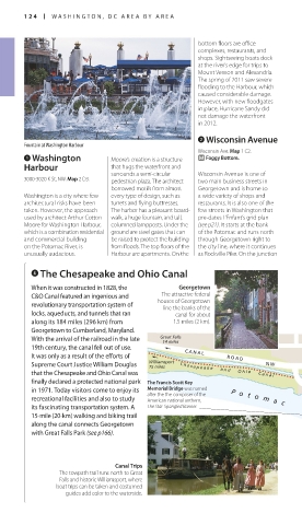
Fountain at Washington Harbour
Wisconsin Ave. Map 1 C2.
1 Washington Moore’s creation is a structure q Foggy Bottom.
Harbour that hugs the waterfront and
surrounds a semi-circular Wisconsin Avenue is one of
3000-3020 K St, NW. Map 2 D3. pedestrian plaza. The architect two main business streets in
bor rowed motifs from almost Georgetown and is home to
Washington is a city where few every type of design, such as a wide variety of shops and
architectural risks have been turrets and flying buttresses. restaurants. It is also one of the
taken. However, the approach The harbor has a pleasant board- few streets in Washington that
used by architect Arthur Cotton walk, a huge fountain, and tall, pre-dates L’Enfant’s grid plan
Moore for Washington Harbour, columned lampposts. Under the (see p21). It starts at the bank
which is a combination residential ground are steel gates that can of the Potomac and runs north
and commercial building be raised to protect the building through Georgetown right to
on the Potomac River, is from floods. The top floors of the the city line, where it continues
unusually audacious. Harbour are apartments. On the as Rockville Pike. On the junction
4 The Chesapeake and Ohio Canal
When it was constructed in 1828, the Georgetown
The attractive federal
C&O Canal featured an ingenious and houses of Georgetown
revolutionary transportation system of line the banks of the
locks, aqueducts, and tunnels that ran canal for about
along its 184 miles (296 km) from 1.5 miles (2 km).
Georgetown to Cumberland, Maryland.
With the arrival of the railroad in the late Great Falls OLIVE STREET NW
14 miles
19th century, the canal fell out of use. PROSPECT STREET NW
C A N A L
It was only as a result of the efforts of R O A D
Supreme Court Justice William Douglas Williamsport N W M S T R E E T N W M S T R E E T N W
75 miles
that the Chesapeake and Ohio Canal was C h e s a p e a k e a n d O h i o C a n a l CANAL ST NW PENNSYLVANIA
AVENUE
finally declared a protected national park The Francis Scott Key C h e s a p e a k e a n d O h i o C a n a l WISCONSIN AVE NW Wisconsin Ave
in 1971. Today visitors come to enjoy its Memorial Bridge was named Bridge
after the the composer of the
recreational facilities and also to study American national anthem, GRACE ST NW 31ST STREET NW THOMAS JEFFERSON ST NW 30TH ST NW 29TH ST NW
its fascinating transportation system. A The Star-Spangled Banner. P o t o m a c W H I T E H U R S T CECIL PL NW SOUTH ST NW
Francis Scott Key
Memorial Bridge
15-mile (20-km) walking and biking trail
along the canal connects Georgetown F R E E W AY K ST NW
with Great Falls Park (see p166). R i v e r N W
Washington ROCK CREEK AND POTOMAC PARKWAY NW
Harbour
Canal Trips
The towpath trail runs north to Great J
Falls and historic Williamsport, where
boat trips can be taken and costumed
guides add color to the waterside.
124-125_EW_Washington.indd 124 04/04/17 2:29 pm