
Page 20 - (DK Eyewitness) Travel Guide - The Netherlands
P. 20
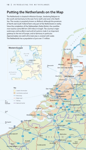
18 INTRODUCING THE NE THERLANDS
Putting the Netherlands on the Map
The Netherlands is situated in Western Europe, bordering Belgium to Norden Bremerhaven
the south and Germany to the east. To its north and west is the North Wilhelmshaven
Sea. The country is popularly known as Holland, although the provinces
of North and South Holland form only part of the Netherlands in reality. EMS Jude Kanal
Since the completion of the Deltawerken (Delta Works), the coastline
now reaches some 800 km (500 miles) in length. The country’s major Emden
waterways and excellent road and rail systems make it an important e G RONINGEN
gateway to the rest of Europe, and to Germany in particular. e Leer
Approximately one-sixth of its total area is covered with water. n z Groningen Oldenburg
The Netherlands has a population of just over 17 million. e Leeuwarden Hunte
d
d Groningen
a FRIESLAND Friesoythe
W Assen
Western Europe NORWAY
Den Helder Heerenveen DRENTHE Cloppenburg
SWEDEN
Vechta
Nor th NOORD Emmen
DENMARK
Sea HOLLAND
IJsselmeer
REP. OF Enkhuizen Meppel Hoogeveen Meppen
IRELAND UNITED Amsterdam
KINGDOM NETHERLANDS
GERMANY Hoorn Vecht GERMANY
BELGIUM Alkmaar Lingen
CZECH Newcastle
REPUBLIC Markermeer
See inset map below Zwolle OVER-
FLEVO- Nordhorn
FRANCE AUSTRIA Leylstad LAND IJSSEL Mittelland Kanal
Atlantic SWITZ. Almelo
Ocean ITALY NETHERLANDS Osnabrück
Haarlem AMSTERDAM Almere Rheine
Deventer Hengelo Ems
SP AIN
Schiphol
Apeldoorn Enschede
Münster
Berkel
Amersfoort
Leiden
Key ZUID Utrecht
Den Haag HOLLAND IJssel GELDERLAND
Greater Amsterdam UTRECHT Arnhem
Delft Gouda
Land below sea level Rotterdam Lek L ek Coesfeld
Motorway Hoek van
Holland Rotterdam
Major road aal Nijmegen
Railway Barendrecht W
Hull, Dordrecht Rhein
Harwich National border
's Hertogenbosch Wesel
Zierikzee NOORD BRABANT
Breda
Hull ZEELAND Tilburg Maas
Bergen Helmond
Middelburg op Zoom Eindhoven Eindhoven
Blerick Krefeld
Zeebrugge Turnhout
Ramsgate LIMB URG
Antwerpen Mönchengladbach
Oostende Albert Kanaal
Brugge Antwerpen Zuid Willemsvaart Rur
Kanaal
Nieuwpoort Mechelen
Gent Demer
BELGIUM Maastricht
Kortrijk Brussels Leuven Sint- Hasselt Maastricht
Ieper Bruxelles Truiden Aachen
Oudenaarde
For map symbols see back flap
018-019_EW_Netherlands.indd 18 16/01/17 12:02 pm
Eyewitness Travel LAYERS PRINTED:
Orientations template “UK” LAYER
(Source v1.3)
Date 6th November 2012
Size 125mm x 217mm