
Page 87 - All About History - Issue 180-19
P. 87
hiddenMapsTories
a view of
The world
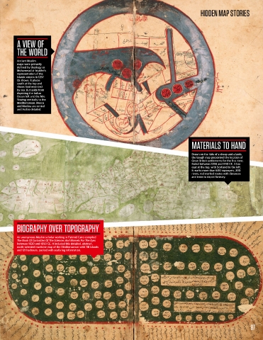
Ancient Muslim
maps were primarily
defined by theology as
Muhammad al-Istakhrī’s
representation of the
Islamic empire in 1297
CE shows. It places
south at the top and
shows land encircled
by sea. But aside from
depicting the Indian
Ocean left and the Nile
flowing vertically to the
Mediterranean, Mecca
and Medina are central
and Arabia detailed.
MaTerials To hand
Drawn on the hide of a sheep and a lamb,
the Gough map pinpointed the location of
Great British settlements for the first time.
Dated between 1390 and 1410 CE, it has
east at the top, with Scotland to the left.
It marks more than 600 toponyms, 200
rivers, red-marked routes with distances
and trees to depict forestry.
Biography over Topography
An anonymous Muslim scholar working in Fatimid Cairo compiled
The Book Of Curiosities Of The Sciences And Marvels For The Eyes
between 1020 and 1050 CE. It included this detailed, abstract,
north-oriented maritime map of the Mediterranean with 118 islands
and 121 harbours, packed with seafaring information.
87