
Page 89 - All About History - Issue 180-19
P. 89
hidden Map sTories
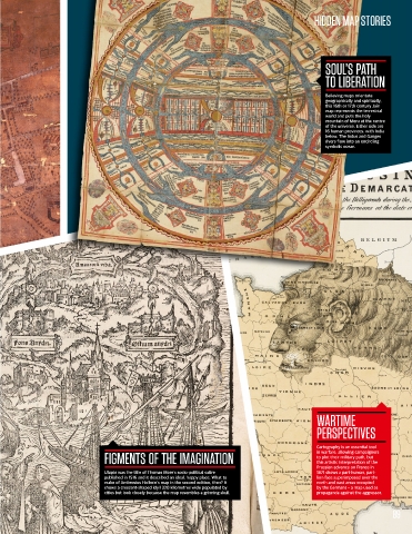
soul’s paTh
To liBeraTion
Believing maps orientate
geographically and spiritually,
this 16th or 17th century Jain
map represents the terrestrial
world and puts the holy
mountain of Meru at the centre
of the universe. Either side are
16 human provinces, with India
below. The Indus and Ganges
rivers flow into an encircling
symbolic ocean.
warTiMe
perspecTives
Cartography is an essential tool
in warfare, allowing campaigners
figMenTs of The iMaginaTion to plot their military path, but
this artistic interpretation of the
Prussian advance on France in
Utopia was the title of Thomas More’s socio-political satire 1871 shows a part-human, part-
published in 1516 and it described an ideal, happy place. What to lion face superimposed over the
make of Ambrosius Holbein’s map in the second edition, then? It north and east areas occupied
shows a crescent-shaped idyll 320 kilometres wide populated by by the Germans – a map used as
cities but look closely because the map resembles a grinning skull. propaganda against the aggressor.
89